Bowraville, New South Wales

Last updated

Bowraville
New South Wales
Australia New South Wales location map blank.svg
Red pog.svg
Bowraville
Coordinates 30°38′S152°51′E / 30.633°S 152.850°E / -30.633; 152.850
Population1,157 (2021 census) [1]
Postcode(s) 2449
Elevation24.8 m (81 ft)
Location
LGA(s) Nambucca Valley Council
County Raleigh
State electorate(s) Oxley
Federal division(s) Cowper

Bowraville is a small town in the Mid North Coast hinterland of New South Wales, Australia in the Nambucca Valley. The town is known for tourism with attractions such as a folk museum, a war museum, a historic theatre, and other historic buildings.

Contents

Bowraville is considered one of the most disadvantaged towns in New South Wales with low income levels, high unemployment, and a high proportion of students not meeting education standards. [2] [3] [4] On 5 November 2011, however, Bowraville was honoured as the Winner of the Cultural Heritage Award and came third overall in the Tidy Towns Awards by Keep Australia Beautiful – Tidy Towns.

Bowraville Bowraville.jpg
Bowraville

History

The Indigenous Gumbaynggirr and Ngaku [5] people have inhabited the area for thousands of years, and today around 15% of the population are Indigenous Australians. The Gumbaynggirr lands cover an area of the Mid North Coast from the Nambucca River to as far north as the Clarence River (Grafton), west to Armidale and eastward to the Pacific coast. [6] The area was mostly subtropical rainforest until the arrival of Europeans.

The word Bowra comes from the Gumbaynggirr place name, Bawrrung, which possibly means cabbage tree palm. [7] Other definitions given have been 'bullrout fish', 'scrub turkey' or 'bald head'. [8] Originally named Bowra, the ville was added to the name in the 1870s to avoid confusion with the Southern Highlands town of Bowral.

In March 1841, Clement Hodgkinson explored the upper reaches of the Nambucca and Bellinger Rivers. He was the first European to make contact with the local Aboriginal communities. The township grew up in the 1850s and 1860s.

The town was gazetted in 1870 and Bowraville Post Office opened on 1 August 1870., [9] and became the main centre of the Nambucca Valley. Its early industries were mainly timber and dairy, and the town eventually came to inherit the Nambucca Shire Council chambers. From about the 1960s, however, Bowraville began to decline in popularity and wealth.

Timber Industry

White settlement began in the area with the timber-getters. The first timber-getter into the area was Mr William Scott (after whom Scotts Head is named). The most popular timber was by far red cedar, of which there are now few trees left. Hoop pine was also popular. Like many Australian timber towns of this era, the town thrived for several decades, and by the 1870s boasted two hotels, several general stores, a blacksmith's, tailor, post office, a school and a number of churches.

Agriculture

By the 1880s the district was also an important dairy and pig raising area. Timber began to decline as the dominant industry by the early 20th Century, as the supply became scarce. Many jobs have been lost in recent years with the decline of the timber industry however agriculture has diversified from the traditional core of dairy farming to include beef cattle. The area has also seen the development of such activities as macadamia farms, avocado growers, agro forestry, bush foods, alpacas and organic vegetables.

The town remained relatively static throughout the 20th Century but by the 1980s this area of the New South Wales coast was attracting people looking for a better lifestyle. Today this is apparent in venues like the restored historical theatre in the main street.

Murders

Between 1990 and 1991, three children in Bowraville were murdered. Despite two trials and much publicity, there have been no convictions for the murders. On 26 May 2016, after efforts of the families and two refusals from the Attorneys General, then Attorney General of New South Wales Gabrielle Upton announced that the NSW Court of Criminal Appeal would hear the case. Publicity generated by a popular podcast from The Australian called Bowraville [10] [11] possibly helped finally create enough public pressure to force the Attorney General in this decision.

Bowra Theatre

The Bowraville Theatre has become a popular tourist attraction on the Mid North Coast hinterland. Built in 1940 as a picture theatre, it was derelict for many years but it now operates as a performance space for the local theatre group, writers' group, and choir, as well as in its traditional role as a cinema. The local community brought the theatre back to life, through volunteer work and fund raising. The restored foyer was opened at the end of 2002 and on Friday 29 August 2003, the theatre re-opened its doors. The Indigenous community held a smoking ceremony and performed a welcome dance. [12]

Like many businesses in country towns at the time of its construction, the theatre operated as a racially divided business. Aboriginal people had to buy their tickets separately, enter the theatre by a separate side entrance, sit in inferior seating below an interior partition and were permitted to do so only after the program had begun. [13] As a result, the theatre was a stop-off on the 1965 Freedom Ride which saw students from University of Sydney tour regional NSW to highlight racism against Aboriginal people.

Demographics

Historical population
YearPop.±%
19541,047    
19611,003−4.2%
1966883−12.0%
1971845−4.3%
1976801−5.2%
1981848+5.9%
19861,024+20.8%
1991963−6.0%
1996933−3.1%
2001954+2.3%
2006976+2.3%
20111,090+11.7%
2016950−12.8%
2021941−0.9%
Source: Australian Bureau of Statistics data. [14] [15]

According to the 2016 Australian census [1] the median age in Bowraville is 45. The population of the town is 1,122, a decrease from 1,208 in 2011. 14.8% of residents are Aboriginal or Torres Strait Islander with the median age among this group being 21. Bowraville has a higher than average number of residents aged 65+.

84.6% of residents reported being born in Australia, higher than the national average of 66.7%. Other than Australia the most common countries of birth are England (3.3%), New Zealand (1.4%) and Germany (0.6%). 75.3% also report both parents having been born in Australia, significantly higher than the national average of 47.3%. 90.0% of people spoke only English at home.

The top religious groups in Bowraville are Anglican 22.7%, Catholic 21.7% and Uniting Church 5.7%. 26.8% of residents report no religion.

Local media

Radio Stations

hit (105.5 & 105.1), Triple M (2MC-FM 106.7 & 2CS-FM 106.3), Triple J (91.5 & 96.3), 2NVR FM (105.9)

The Nambucca Valley's community radio station, 2NVR 105.9FM, focuses on the Macksville, Bowraville, Nambucca Heads and surrounding communities.

Newspapers

Notable people

Related Research Articles

<span class="mw-page-title-main">Coffs Harbour</span> City in New South Wales, Australia

Coffs Harbour, locally nicknamed Coffs, is a coastal city on the Mid North Coast of New South Wales, Australia, 540 km (340 mi) north of Sydney, and 390 km (240 mi) south of Brisbane. It is one of the largest urban centres on the North Coast, with a population of 78,759 as per 2021 census. The Gumbaynggirr are the original people of the Coffs Harbour region.

Aden Derek Ridgeway is an Australian former politician. He was a member of the Australian Senate for New South Wales from 1999 to 2005, representing the Australian Democrats. During his term he was the only Aboriginal member of the Australian Parliament. He is currently a spokesperson for Recognise, the movement to recognise Aboriginal and Torres Strait peoples in the Australian Constitution.

<span class="mw-page-title-main">Northern Rivers</span> Region in New South Wales, Australia

Northern Rivers is the most north-easterly region of the Australian state of New South Wales, located between 590 and 820 kilometres north of the state capital, Sydney, and encompasses the catchments and fertile valleys of the Clarence, Richmond, and Tweed rivers. It extends from Tweed Heads in the north to the southern extent of the Clarence river catchment which lies between Grafton and Coffs Harbour, and includes the main towns of Tweed Heads, Byron Bay, Ballina, Kyogle, Lismore, Casino and Grafton. At its most northern point, the region is 102 kilometres (63 mi) south-southeast of the Queensland capital, Brisbane.

<span class="mw-page-title-main">Macksville, New South Wales</span> Town in New South Wales, Australia

Macksville is a small town on the Nambucca River in the Nambucca Valley, New South Wales, Australia. It is halfway between Sydney and Brisbane, along the Pacific Highway, approximately 40 minutes north of Kempsey, 40 minutes south of Coffs Harbour, 70 minutes north of Port Macquarie, five hours south of Brisbane and five hours north of Sydney.

<span class="mw-page-title-main">Nambucca Valley Council</span> Local government area in New South Wales, Australia

Nambucca Valley Council is a local government area in the Mid North Coast region of New South Wales, Australia.

<span class="mw-page-title-main">Mid North Coast</span> Region in New South Wales, Australia

The Mid North Coast is a country region in the north-east of the state of New South Wales, Australia. The region, situated 416km north of Sydney, covers the mid northern coast of the state, beginning from Port Stephens at Hawks Nest to as far north as Woolgoolga, near Coffs Harbour. The region has many beaches and subtropical national parks and forests as well as rural farmland and logging. Major coastal towns include Coffs Harbour, Forster and Port Macquarie. The Mid North Coast is a popular destination for camping or resorts and surfing, with coastal and hinterland tracks, with the unique heritage-listed mountain village of Bellbrook popular for day trips inland or 4wd campers and keen bass fishers.

<span class="mw-page-title-main">Yamba, New South Wales</span> Town in New South Wales, Australia

Yamba is a town in the Northern Rivers region of New South Wales, Australia located at the mouth of the Clarence River.

<span class="mw-page-title-main">Urunga, New South Wales</span> Town in New South Wales, Australia

Urunga is a small town located within the Mid North Coast region of New South Wales, Australia, in Bellingen Shire. It is famous for its surf spots. At the 2021 census, Urunga had a population of 3,185. The town is south of Coffs Harbour and Sawtell and north of Nambucca Heads. The place name is derived from the Gumbaynggir word Yurūnga, which is derived from the word for long yurūn in reference to "long white sands".

<span class="mw-page-title-main">Nambucca Heads</span> Town in New South Wales, Australia

Nambucca Heads is a town on the Mid North Coast of New South Wales, Australia in the Nambucca Valley. It is located on a ridge, north of the estuary of the Nambucca River near the Pacific Highway. Its 2021 population was 6,675, including 5,226 (78.3%) Australian-born persons and 672 indigenous persons.

Group 2 is a rugby league competition on the north coast of New South Wales Since 1966, run under the auspices of the Country Rugby League. The Group 2 area runs from Grafton in the north to Macksville in the south. Group 2 teams played for many decades before 1966 when some redistribution, amalgamation or control mechanism presumably changed. Teams on the Nambucca River, namely Bowraville, Macksville and Nambucca Heads played in a southern division against Kempsey, Smithtown, Port Macquarie and Wauchope before 1966.

<span class="mw-page-title-main">Woolgoolga, New South Wales</span> Town in New South Wales, Australia

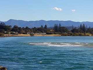
Woolgoolga is a town on the Mid North Coast of New South Wales, Australia. It is on the Pacific Highway, approximately 550 km north of Sydney and 365 km south of Brisbane. The closest city to Woolgoolga is Coffs Harbour, which lies 24.8 km to the south. Woolgoolga has two beaches on the Pacific Ocean. The area has long been a centre of banana growing in New South Wales, but this industry has declined in the face of competition from Queensland. Recent times have seen many banana plantations replaced by blueberries after banana sales slumped in the late 1990s.

<span class="mw-page-title-main">Scotts Head, New South Wales</span> Suburb of Nambucca Valley Council, New South Wales, Australia

Scotts Head is a coastal village of the Nambucca Valley local government area in the Mid North Coast region of New South Wales, Australia. Located on the coast of the Pacific Ocean, approximately 10 kilometres (6 mi) from the Pacific Highway and 480 kilometres (300 mi) from Sydney, it stretches southwards from just south of the mouth of the Nambucca River to the town of Scotts Head in the south.

<span class="mw-page-title-main">Bowraville murders</span>

The Bowraville murders is the name given to three deaths that occurred over five months from September 1990 to February 1991 in Bowraville, New South Wales, Australia. All three victims were Aboriginal, and all disappeared after parties in Bowraville's Aboriginal community, in an area known as The Mission. A local labourer, who was regarded by police as the prime suspect, was charged with two of the murders but was acquitted following trials in 1994 and 2006. On 13 September 2018, the New South Wales Court of Criminal Appeal decided that the man could not be retried for the murders. On 22 March 2019, the High Court of Australia refused an application by the Attorney General of New South Wales to bring an appeal against that decision.

<span class="mw-page-title-main">Gumbaynggirr language</span> Australian Aboriginal language

Gumbaynggir language is an Australian Aboriginal language spoken by the Gumbaynggirr people, who are native to the Mid North Coast of New South Wales.

The Gumbaynggirr people, also rendered Kumbainggar, Gumbangeri and other variant spellings, are an Aboriginal Australian people of the Mid North Coast of New South Wales. Gumbathagang was a probable clan or sub-group. The traditional lands of the Gumbaynggirr nation stretch from Tabbimoble Yamba-Clarence River to Ngambaa-Stuarts Point, SWR- Macleay to Guyra and to Oban.

<span class="mw-page-title-main">Les Murdoch</span>

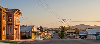
Les Murdoch, based in Bowraville, New South Wales, Australia is a contemporary artist who began painting in the mid-1990s.

<span class="mw-page-title-main">North Coast Computer Project</span>

The North Coast Computer Project (NCCP) is an Australian independent not-for-profit social enterprise established in 2003. NCCP focuses on helping aboriginal communities and other organisations and communities access the same level of technology taken for granted by many.

Coffs Harbour High School is a government-funded co-educational comprehensive secondary day school, located in Coffs Harbour, in the Mid North Coast region of New South Wales, Australia. The aboriginal country the school is built on is Gumbaynggirr Country.

Giinagay Way is a road in the Mid North Coast region of New South Wales linking the towns of Warrell Creek, Macksville, Nambucca Heads and Urunga to Pacific Highway. It runs along a former section of the highway between Eungai Creek and Raleigh that was bypassed by a new parallel alignment between 2016 and 2018.

Muurrbay Aboriginal Language and Culture Co-operative is a language revitalisation centre for Aboriginal Australian languages of a region in New South Wales, situated in Nambucca Heads.

References

  1. 1 2 Australian Bureau of Statistics (28 June 2022). "Bowraville". 2021 Census QuickStats. Retrieved 13 March 2024. OOjs UI icon edit-ltr-progressive.svg
  2. "Study shows social disadvantage on the Coffs Coast". Coffs Coast Advocate.
  3. Benny-Morrison, Ava (27 May 2016). "Bowraville: How three families from a disadvantaged country town took on the state". Sydney Morning Herald .
  4. "Study shows social disadvantage on the Coffs Coast". Toowoomba Chronicle .
  5. "DNAAG Aboriginal Art Gallery". DNAAG Aboriginal Art Gallery.
  6. "Gumbaynggirr - Bowraville.org.au". Archived from the original on 18 February 2011. Retrieved 5 May 2010.
  7. "BOWRAVILLE Tourism". www.nnsw.com.au.
  8. "Bowraville". Sydney Morning Herald . 1 January 2009.
  9. Premier Postal History. "Post Office List". Premier Postal Auctions. Retrieved 5 May 2011.
  10. "Bowraville on Apple Podcasts". Apple Podcasts. Retrieved 17 March 2020.
  11. "Bowraville". The Australian . 16 May 2018. Retrieved 9 March 2020.
  12. "Bowraville Theatre". Archived from the original on 17 February 2011. Retrieved 24 August 2010.
  13. "Bowra Theatre". Archived from the original on 18 February 2011. Retrieved 24 August 2010.
  14. "Statistics by Catalogue Number". Australian Bureau of Statistics. Retrieved 8 January 2024.
  15. "Search Census data". Australian Bureau of Statistics. Retrieved 8 January 2024.