Ebor is a village on Waterfall Way on the Northern Tablelands in New South Wales, Australia. It is situated about 80 km (50 mi) east of Armidale and about a third of the way between Armidale and the coast. Dorrigo to the east is 46 kilometres (29 mi) away with the Coffs Coast 55 kilometres (34 mi) away along Waterfall Way. In the 2021 census, Ebor's zone had a population of 149.

Bellingen is a small town in the Mid North Coast of New South Wales, Australia. It is located on Waterfall Way on the Bellinger River, approximately halfway between the major Australian cities of Sydney and Brisbane. In 2021, the population of Bellingen township was 3,923 and Bellingen shire was 13,253, and it is the council seat of Bellingen Shire.

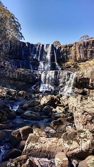
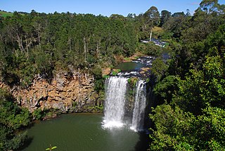
Waterfall Way is a 170-kilometre (110 mi) country road in the Northern Tablelands region of New South Wales, Australia, linking Raleigh on the state's North Coast to Armidale. The route passes through some of New South Wales' most scenic countryside and has become well known as its best and Australia's third most beautiful tourist drive. Seven national parks, of which three are listed as World Heritage Areas by UNESCO and form part of the Gondwana Rainforests of Australia, are located on or close to the route. Dorrigo National Park encompasses the waterfalls that give the route its name.

Pomona is a rural town and locality in the Shire of Noosa, Queensland, Australia. In the 2016 census the locality of Pomona had a population of 2,910 people. Pomona is located around 135 kilometres north of Brisbane. It is located at the base of Mount Cooroora at the northern end of the Sunshine Coast.
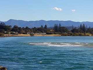
Urunga is a small town located within the Mid North Coast region of New South Wales, Australia, in Bellingen Shire. It is famous for its surf spots. At the 2011 census, Urunga had a population of 3,020. The town is south of Coffs Harbour and Sawtell and north of Nambucca Heads. The place name, Urunga, is derived from the Gumbaynggir word Yurūnga, which is derived from the word for long yurūn in reference to "long white sands".

Bellingen Shire is a local government area in the Mid North Coast region of New South Wales, Australia. The shire is located adjacent to the Pacific Highway, Waterfall Way and the North Coast railway line.
Federal is a rural locality in the Shire of Noosa, Queensland, Australia. In the 2016 census, Federal had a population of 303. It is located in the Sunshine Coast hinterland near the towns of Cooran and Pomona.

The Dorrigo railway line is a closed railway line in the north of New South Wales, Australia. It branches from the North Coast line at Glenreagh.

Dorrigo, a small town on the Waterfall Way, is located on the Northern Tablelands, in northern New South Wales, Australia. The town is part of Bellingen local government area.

The Nymboida River, a perennial stream of the Clarence River catchment, is located in the Northern Rivers region of New South Wales, Australia.
Blicks River, a perennial stream that is part of the Clarence River catchment, is located in the Northern Tablelands district of New South Wales, Australia.
Glen Fernaigh River, a perennial river of the Clarence River catchment, is located in the Northern Rivers region of New South Wales, Australia.
Never Never River, a perennial stream of the Bellinger River catchment, is located in the Mid North Coast region of New South Wales, Australia.
Urumbilum River, a perennial stream of the Clarence River catchment, is located in the Northern Tablelands and Northern Rivers districts of New South Wales, Australia.
Bielsdown River, a perennial stream that is part of the Clarence River catchment, is located in the Northern Tablelands of New South Wales, Australia.
Little Murray River, a perennial stream of the Clarence River catchment, is located in the Northern Tablelands district of New South Wales, Australia.
Rosewood River, a perennial river of the Bellinger River catchment, is located in the Mid North Coast region of New South Wales, Australia.
Stewart is a civil parish of Fitzroy County in New South Wales. It is located in Bellingen Shire.
Dorrigo Shire was a local government area in the Mid North Coast region of New South Wales, Australia.
Giinagay Way is a road in the Mid North Coast region of New South Wales linking the towns of Warrell Creek, Macksville, Nambucca Heads and Urunga to Pacific Highway. It runs along a former section of the highway between Eungai Creek and Raleigh that was bypassed by a new parallel alignment between 2016 and 2018.
