Macleay River

Last updated

Macleay River
Muddy River [1]
Macleay River.JPG
Macleay River, viewed at Lower Creek
Australia New South Wales relief location map.png
Red pog.svg
Location of the river mouth in New South Wales
Etymology Alexander Macleay [1]
Location
Country Australia
State New South Wales
IBRA New England Tablelands, New South Wales North Coast
District Northern Tablelands, Mid North Coast
Local government area Armidale, Bellingen, Kempsey
Physical characteristics
Source Great Dividing Range
  locationBlue Nobby Mountain, near Uralla
  elevation455 m (1,493 ft)
2nd source Gara River
Source confluenceSalisbury Waters and Bakers Creek
Mouth Tasman Sea
  location
near South West Rocks
  coordinates
30°52′S153°01′E / 30.867°S 153.017°E / -30.867; 153.017
  elevation
0 m (0 ft)
Length298 km (185 mi)
Basin size11,287 km2 (4,358 sq mi)
Discharge 
  locationNear mouth
  average82.5 m3/s (2,600 GL/a) [2]
Basin features
Tributaries 
  left Chandler River, Top Creek, Dyke River, Sunday Creek (New South Wales), Georges Creek, Five Day Creek, Lagoon Creek, Nulla Nulla Creek, Hickeys Creek, Mungay Creek, Christmas Creek
  right Blue Mountain Creek, Apsley River, Kunderang Brook, Carrolls Creek, Felters Creek, Stockyard Creek, Mackenzies Creek, Warbro Brook, Parrabel Creek, Cadiangullong Creek, Dungay Creek
National parks Cunnawarra NP, Oxley Wild Rivers NP
[3]

The Macleay River is a river that spans the Northern Tablelands and Mid North Coast districts of New South Wales, Australia.

Contents

Course and features

Macleay River at Oven Camp, Oxley Wild Rivers National Park. Macleay R.jpg
Macleay River at Oven Camp, Oxley Wild Rivers National Park.

Formed by the confluence of the Gara River, Salisbury Waters and Bakers Creek, the Macleay River rises below Blue Nobby Mountain, east of Uralla within the Great Dividing Range. The river flows in a meandering course generally east by south, joined by twenty-six tributaries including the Apsley, Chandler, and Dyke rivers and passing through a number of spectacular gorges and waterfalls in Cunnawarra National Park and Oxley Wild Rivers National Park, before reaching its mouth at the Tasman Sea, near South West Rocks. The river descends 460 metres (1,510 ft) over its 298 kilometres (185 mi) course. [3]

The river flows through the town of Kempsey. At Frederickton the river is traversed by the Pacific Highway via the Macleay River Bridge (Dhanggati language: Yapang gurraarrbang gayandugayigu). [4] At the time of its official opening in 2013, the bridge was the longest road bridge in Australia. [5] [6] The river is also traversed by the North Coast railway line. [7]

The Macleay River is liable to flooding in the Kempsey area, on occasions causing great damage. [8] [9] [10] During times of peak flooding, the Macleay River can hold over 200,000 gigalitres (44,000,000 million imperial gallons ; 53,000,000 million US gallons ) of water.

History

The Dunghutti, an Aboriginal Australian people, are the traditional custodians of the land surrounding the Macleay River catchment and the Apsley River catchment, whose descendants are now concentrated in the lower Macleay River. Stone artefacts and evidence of Aboriginal stone tool-making have been found around the Macleay and Apsley rivers. [11]

John Oxley failed to realise the potential of this river in 1820 as he did not navigate far enough up-river to see the magnificent stands of timber and the fertile land. The river was vaguely referred to as the New River from descriptions given by Aborigines. In 1826 Captain Wright travelled overland from Port Macquarie and explored to the head of navigation at Belgrave Falls, a series of rapids to the west of the present town of Kempsey. It was then called Wrights River. Major Archibald Clunes Innes, Commandant of Port Macquarie Penal Settlement, sent the first government gang of Australian red cedar ( Toona ciliata ) cutters to work there in 1827.[ citation needed ]

More cedar camps were established on the Macleay during the 1830s and the area was also a haven for escaped convicts. By 1841, about 200 cutters were working on the river area, where violence and theft of logs was not uncommon. Demand and prices dropped in 1842 and cutting along the Macleay diminished although it continued in the upper tributaries. When Europeans arrived in the area around the 1820s the river mouth was just south of Grassy Head, and almost a mile wide with a sand spit in the middle. The small town of Stuarts Point was established on the river just inside to serve arriving ships. [12]

The coastal strip extending from South West Rocks to Grassy Head is a wide delta with various channels connected to the river. Around 1885 English marine engineer John Coode advised on improvements to various rivers and ports in Australia, including the Macleay. The Department of Public Works prepared four plans for improvements to the mouth, Coode favoured improving the existing entrance. In 1893 a flood enlarged an opening near South West Rocks and the department elected to improve that, called the New Entrance, though Coode had thought it not enough to drain all the waters of the district. Work on the new entrance started in April 1896, improving the channel and adding training walls. A new pilot station was built in 1902, establishing the town of South West Rocks. Work was completed in 1906. Today the old mouth has silted up, leaving Stuarts Point on a dead-end reach.[ citation needed ]

Variously known as Wright River, Trail River, New and McLeay rivers, it was named the Macleay River in honour of Innes's father-in-law, Alexander Macleay, Scottish-born scientist and colonial secretary of New South Wales. [1] [13]

See also

Related Research Articles

<span class="mw-page-title-main">Cunnawarra National Park</span> Protected area in New South Wales, Australia

Cunnawarra is a national park located in New South Wales, Australia, 80 kilometres (50 mi) east of Armidale, 10 kilometres (6.2 mi) off the Waterfall Way and 565 kilometres (351 mi) north of Sydney. The 25-kilometre (16 mi) Styx River Forest Way runs from the Point Lookout Road through Cunnawarra National Park to the Kempsey Road. The New England National Park adjoins the Cunnawarra National Park on the north-eastern boundary and the Oxley Wild Rivers National Park joins it on the southern corner.

<span class="mw-page-title-main">Oxley Wild Rivers National Park</span> Protected area in New South Wales, Australia

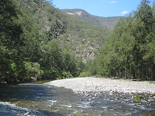
The Oxley Wild Rivers National Park is a protected national park that is located in the Northern Tablelands region of New South Wales, Australia in the Port Macquarie-Hastings City Council and Walcha Shire councils. The 145,223-hectare (358,850-acre) park is situated 445 kilometres (277 mi) north of Sydney and is named in memory of the Australian explorer John Oxley, who passed through the area in 1818 and is one of the largest national parks in New South Wales.

<span class="mw-page-title-main">New England (New South Wales)</span> Region in New South Wales, Australia

New England is a geographical region in the north of the state of New South Wales, Australia, about 60 km inland from the Tasman Sea. The area includes the Northern Tablelands and the North West Slopes regions. As of 2021, New England had a population of 185,560, with over a quarter of the people living in the area of Tamworth Regional Council.

<span class="mw-page-title-main">Bogan River</span> River in Australia

Bogan River, a perennial river that is part of the Macquarie–Barwon catchment within the Murray–Darling basin, is located in the central west and Orana regions of New South Wales, Australia.

<span class="mw-page-title-main">Lachlan River</span> Intermittent river in New South Wales, Australia

The Lachlan River is an intermittent river that is part of the Murrumbidgee catchment within the Murray–Darling basin, located in the Southern Tablelands, Central West, and Riverina regions of New South Wales, Australia.

<span class="mw-page-title-main">Mid North Coast</span> Region in New South Wales, Australia

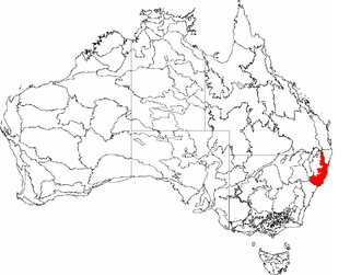
The Mid North Coast is a country region in the north-east of the state of New South Wales, Australia. The region, situated 416km north of Sydney, covers the mid northern coast of the state, beginning from Port Stephens at Hawks Nest to as far north as Woolgoolga, near Coffs Harbour. The region has heaps of beaches and many subtropical national parks and forests as well as rural farmland and logging. Major coastal towns include Coffs Harbour, Forster and Port Macquarie. The Mid North Coast is a popular destination for camping or resorts and surfing, with coastal and hinterland tracks.

<span class="mw-page-title-main">Kempsey, New South Wales</span> Town in New South Wales, Australia

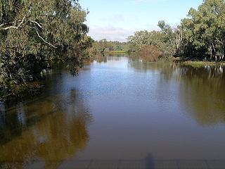
Kempsey is a town in the Mid North Coast region of New South Wales, Australia and is the council seat for Kempsey Shire. It is located roughly 16.5 kilometres inland from the coast of the Pacific Ocean, on the Macleay Valley Way near where the Pacific Highway and the North Coast railway line cross the Macleay River. It is roughly 430 kilometres north of Sydney. As of June 2018 Kempsey had a population of 15,309 (2018).

<span class="mw-page-title-main">Hastings River</span> River in New South Wales, Australia

Hastings River, an open and trained intermediate wave dominated barrier estuary, is located in the Northern Tablelands and Mid North Coast districts of New South Wales, Australia.

<span class="mw-page-title-main">South West Rocks, New South Wales</span> Town in New South Wales, Australia

South West Rocks is a town located on the Mid North Coast of New South Wales, Australia, near the mouth of the Macleay River. It is approximately 40 km (25 mi) from Kempsey. Jerseyville is located nearby.

<span class="mw-page-title-main">Northern Tablelands</span> Region in New South Wales, Australia

The Northern Tablelands, also known as the New England Tableland, is a plateau and a region of the Great Dividing Range in northern New South Wales, Australia. It includes the New England Range, the narrow highlands area of the New England region, stretching from the Moonbi Range in the south to the Queensland border in the north. The region corresponds generally to the Bureau of Meteorology forecast area for the Northern Tablelands which in this case includes Inverell although it is significantly lower in elevation.

<span class="mw-page-title-main">Trial Bay</span> Bay in New South Wales, Australia

Trial Bay is a broad bay on the Mid North Coast of New South Wales, Australia. The bay faces northwards and extends from Laggers Point in the east around to Grassy Head to the west, past the town of South West Rocks and the Macleay River mouth.

<span class="mw-page-title-main">Apsley Falls</span> Two waterfalls on the Apsley River in New South Wales, Australia

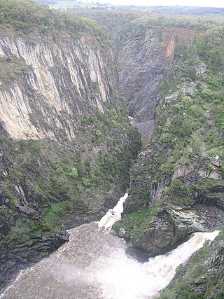
The Apsley Falls are two waterfalls on the Apsley River in the Northern Tablelands region of New South Wales, Australia. The falls are located about 20 kilometres (12 mi) east of Walcha, and 1 kilometre off the Oxley Highway in a deep gorge, that is part of the Oxley Wild Rivers National Park. They are the first falls in a succession of dramatic drops in an area that has some of the most remarkable scenery in Eastern Australia. The first drop of the falls is about 65 metres (213 ft) in depth, and the second, which is about 800 metres (2,625 ft) further on, plummets 58 metres (190 ft) to the bottom of the gorge.

<span class="mw-page-title-main">Apsley River (New South Wales)</span> River in New South Wales, Australia

Apsley River, a perennial stream of the Macleay River catchment, is located in the Northern Tablelands district of New South Wales, Australia.

<span class="mw-page-title-main">Tia River</span> River in New South Wales, Australia

Tia River, a perennial stream of the Macleay River catchment, is located in the Northern Tablelands district of New South Wales, Australia.

<span class="mw-page-title-main">Yarrowitch River</span> River in New South Wales, Australia

Yarrowitch River, a perennial stream of the Macleay River catchment, is located in the Northern Tablelands district of New South Wales, Australia.

<span class="mw-page-title-main">Chandler River (New South Wales)</span> River in New South Wales, Australia

Chandler River, a perennial stream of the Macleay River catchment, is located in the Northern Tablelands district of New South Wales, Australia.

Kempsey Airport is a small airport located in Aldavilla 4 nautical miles west of Kempsey, New South Wales, Australia. The airport is operated by Kempsey Shire Council and is mainly used for general aviation activities, including flight training, skydiving and emergency services uses. There are currently no scheduled passenger services to Kempsey.

<span class="mw-page-title-main">Electoral district of Oxley</span> State electoral district of New South Wales, Australia

Oxley is an electoral district of the Legislative Assembly in the Australian state of New South Wales.

<span class="mw-page-title-main">Djangadi</span> Aboriginal Australian people from Macleay Valley, New South Wales

The Djangadi people, also spelt Dhungatti, Dainggati, Tunggutti or Dunghutti are an Aboriginal Australian people resident in the Macleay Valley of northern New South Wales.

<span class="mw-page-title-main">South West Rocks Pilot Station Complex</span> Historic site in New South Wales, Australia

South West Rocks Pilot Station Complex is a heritage-listed former pilot station at 5 Ocean Drive, South West Rocks, Kempsey Shire, New South Wales, Australia. It was built in 1902 by C. B. Smith. It was added to the New South Wales State Heritage Register on 2 June 2008.

References

  1. 1 2 3 "Macleay River". Geographical Names Register (GNR) of NSW. Geographical Names Board of New South Wales . Retrieved 11 March 2013. OOjs UI icon edit-ltr-progressive.svg
  2. "East Coastal Watersheds".
  3. 1 2 "Map of Macleay River, NSW". Bonzle Digital Atlas of Australia. Retrieved 11 March 2013.
  4. Connaughton, Todd (1 December 2015). "It's the Macleay Valley Bridge (and the 'yapang gurraarrbang gayandugayigu')". Macleay Argus. Retrieved 4 April 2020.
  5. "Australia's longest bridge crosses the Macleay River in Northern NSW". Macleay River and Floodplain Bridge, Kempsey, NSW. Arup Group. March 2013. Retrieved 4 April 2020.
  6. "Mid-year start for project to complete Kempsey Bypass". Media Monitors. 1 March 2011. Retrieved 1 April 2011.[ permanent dead link ]
  7. Chisholm, Alec H., ed. (1963). "Macleay River". The Australian Encyclopaedia. Vol. 4. Sydney: Halstead Press. p. 444.
  8. "Disastrous flood in the Macleay River". Maitland Mercury & Hunter River General Advertiser . National Library of Australia. 25 August 1864. Retrieved 11 March 2013.
  9. "Taming savage Macleay is big but urgent task". Sydney Morning Herald . National Library of Australia. 16 July 1952. Retrieved 11 March 2013.
  10. "The nature of flooding in the Kempsey Shire" (PDF). Kempsey Shire Local Flood Plan. Kempsey Shire Council. November 2011. Archived from the original (PDF) on 19 May 2009. Retrieved 11 March 2013.
  11. "OXLEY WILD RIVERS NATIONAL PARK,OXLEY WILD RIVERS STATE CONSERVATION AREA,CUNNAWARRA NATIONAL PARK ANDGEORGES CREEK NATURE RESERVE: PLAN OF MANAGEMENT" (PDF). Department of Planning & Environment . NSW National Parks & Wildlife Service. 2005. Retrieved 27 March 2021.
  12. Neil, Marie H (1972). "Chapters 1 and 10". Valley of the Macleay. ISBN   0-85587-037-0.
  13. Kay, Donald, J (1978). Exploring the North Coast and New England. Kenthurst: Kangaroo Press. ISBN   0-86417-121-8.{{cite book}}: CS1 maint: multiple names: authors list (link)