Hawkesbury River

Last updated

Hawkesbury-Nepean River
Hawkesbury River, Northern Sydney aerial.jpg
Aerial photograph showing the mouth of the Hawkesbury River as it flows into Broken Bay and out into the Tasman Sea, as seen looking across Sydney's Northern Beaches
Hawkesbury River
Native nameDyarubbin (Dharuk)
Location
Country Australia
State New South Wales
Region Greater Metropolitan Sydney
Physical characteristics
Source Nepean River
  locationnorth of Penrith
2nd source Grose River
Mouth Broken Bay
  location
west of Lion Island
  coordinates
33°33′53.9994″S151°18′0″E / 33.564999833°S 151.30000°E / -33.564999833; 151.30000
Length120 km (75 mi)
Basin size21,624.1 km2 (8,349.1 sq mi)
Discharge 
  locationNear mouth
  average150.2 m3/s (4,740 GL/a) [1] 95 m3/s (3,400 cu ft/s)
  minimum0 m3/s (0 cu ft/s)
  maximum15,000 m3/s (530,000 cu ft/s)
Basin features
Tributaries 
  left Colo River, Webbs Creek, Macdonald River, Mangrove Creek, Popran Creek, Mooney Mooney Creek
  rightCattai Creek, South Creek, Berowra Creek
Islands Milson Island, Peat Island, Spectacle Island, Long Island, and Dangar Island

The Hawkesbury River, or Hawkesbury-Nepean River, is a river located northwest of Sydney, New South Wales, Australia. The Hawkesbury River and its associated main tributary, the Nepean River, almost encircle the metropolitan region of Sydney. Between Wisemans Ferry and the Pacific Ocean marks the boundary of Greater Metropolitan Sydney in the south and the Central Coast region to the north.

Contents

The Hawkesbury River has its origin at the confluence of the Nepean River and the Grose River, to the north of Penrith and travels for approximately 120 kilometres (75 mi) in a north–easterly and then a south–easterly direction to its mouth at Broken Bay, about 15 kilometres (9.3 mi) from the Tasman Sea. The Hawkesbury River is the main tributary of Broken Bay. Secondary tributaries include Brisbane Water and Pittwater, which, together with the Hawkesbury River, flow into Broken Bay and thence into the Tasman Sea north of Barrenjoey Head.

The total catchment area of the river is approximately 21,624 square kilometres (8,349 sq mi) and the area is generally administered by the Hawkesbury–Nepean Catchment Management Authority.

The land adjacent to the Hawkesbury River was occupied by Aboriginal peoples: the Darkinjung, Darug, Eora, and Kuringgai. They used the river as a source of food and a place for trade. [2] In the languages of the traditional custodians the river is Deerubben or Dyarubbin. [3] [4] [5]

In March 2021, the river level rose, and many areas were flooded as part of the March 2021 Australian floods. [6]

Course

Looking north-east across the Hawkesbury River, with Dangar Island to the right of the image. 2007 0817klklk0035.JPG
Looking north-east across the Hawkesbury River, with Dangar Island to the right of the image.
Looking south-east across the Hawkesbury River, from near Brooklyn. 2007 0817klklk0030.JPG
Looking south-east across the Hawkesbury River, from near Brooklyn.

The headwaters of the Hawkesbury River, the Avon River, the Cataract River, and the Cordeaux River, rise only a few kilometres (miles) from the sea, about 80 kilometres (50 mi) south of Sydney. These streams start on the inland-facing slopes of the plateau which forms the escarpment behind Wollongong. Flowing north-west, away from the sea, these streams combine to form the Nepean River, and flow north past the towns of Camden and Penrith. Near Penrith, the Warragamba River emerges from its canyon through the Blue Mountains and joins the Nepean. The Warragamba, formed by the joining of the Wollondilly River, the Nattai River, the Kowmung River and Coxs River drains a broad region of New South Wales on the eastern side of the Great Dividing Range. The other principal component of the upper Hawkesbury river system, the Grose River, rises in the area of Mount Victoria in the Blue Mountains.

Once formed, the Hawkesbury River proper flows generally northwards, albeit with a significant number of meanders. Initially the river passes the towns of Richmond and Windsor, which are the largest settlements on the river. At Windsor, the river is joined by South Creek, which drains much of the urban runoff in Sydney's western suburbs that does not fall into the Parramatta River catchment. As it flows north, it enters a more rural area, with only small settlements on the river. On this stretch it passes Sackville and Lower Portland, where it is joined by the Colo River. The Colo River and its tributaries drain the northern section of the Blue Mountains. [7]

From Lower Portland, the Hawkesbury River continues flowing northwards to the small community of Wisemans Ferry where it is joined by the Macdonald River. Here its course turns eastwards and the surrounding landscape gradually becomes steeper and more rugged. At Spencer, Mangrove Creek joins the river from the north. From here to the river mouth, road access to the river is limited to a few points.

At Milsons Passage, the river is joined by Berowra Creek from the south. In the area around Brooklyn the river is crossed by the major road and rail services that follow the coast north from Sydney. The river finally reaches the ocean at Broken Bay.

From the confluence of the Nepean and Grose Rivers to the sea, the Hawkesbury River has a total length of some 120 kilometres (75 mi). [8]

Islands

Islands in the Hawkesbury River include, in order going downstream are Barr Island, Milson Island, Snake Island, Peat Island, Spectacle Island, Long Island, Dangar Island and Lion Island.

Crossings

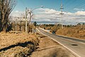
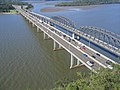
Despite forming the effective boundary of the metropolitan region of Sydney for its entire length, there are very few fixed crossings of the Hawkesbury River proper. Going downstream, these comprise:

Crossing name
(Unofficial name)
North bank crossing location South bank crossing location Comments/use Image
Richmond Bridge North Richmond Richmond A bridge that carries the historic Bells Line of Road and formerly carried the Kurrajong extension of the Richmond railway line. North.richmond.bridge.1986.jpg
Windsor Bridge Freemans Reach Windsor A bridge that carries the Putty Road.
Sackville Ferry Sackville A vehicular cable ferry. Sackville ferry gnangarra-15.jpg
Lower Portland Ferry Lower Portland A vehicular cable ferry.
Webbs Creek Ferry Wisemans Ferry A vehicular cable ferry just upstream of the settlement of Wisemans Creek. Webbs creek ferry-1w.jpg
Wisemans Ferry A vehicular cable ferry at the settlement of Wisemans Creek that carries the old Great North Road. Wisemans Ferry.jpg
Brooklyn Bridge Mooney Mooney Kangaroo Point Carries the Sydney-Newcastle Freeway parallel to Peats Ferry Bridge. Hawkesbury River road bridges.jpg
Peats Ferry Bridge An older bridge that carries the Pacific Highway.
Hawkesbury River Railway Bridge Cogra Point Brooklyn A bridge that carries the Main Northern railway line. Hawkesbury River rail bridge.jpg

In the lower reaches of the river there are also a few passenger ferries that cross the river. These include the Palm Beach Ferry service from Palm Beach to Ettalong and Wagstaffe, and the Hawkesbury River Ferries service from Brooklyn to Dangar Island and Little Wobby.

History

Aboriginal Australian history

A list from 1829 made by Reverend John McGarvie [9] includes the place names used by the Aboriginal people along the river, including the name of the river itself Dyarubbin. [4] [10] [11] An alternative spelling of the Aboriginal name for the river was published as Deerubbun in 1870. [12] The two main Aboriginal tribes inhabiting the area were the Wannungine of the coastal area on the lower reaches (below Mangrove Creek) and the Darkinyung people, whose lands were extensive on the lower Hawkesbury to Mangrove Creek, upper Hawkesbury, inland Hunter and lower Blue Mountains. [3] Also known on the banks of the river were the Eora and Guringai people. [13]

Australian history since colonisation

The Hawkesbury River was renamed by Governor Phillip in 1789 Australia nsw brooklyn obelisk.jpg
The Hawkesbury River was renamed by Governor Phillip in 1789

In 1789 two expeditions explored the Hawkesbury to the northwest of Sydney and the Nepean River to the southwest. It took about three years to realise they had discovered the same river system.[ citation needed ] Hawkesbury River was one of the pivotal positions of the Hawkesbury and Nepean Wars, a series of skirmishes and battles between the Kingdom of Great Britain and the resisting Indigenous clans that took place between late 1780s and late 1810s. [14] [15]

The Hawkesbury River was one of the major transportation routes for transporting food from the surrounding area to Sydney during the 1800s. Boats would wait in the protection of Broken Bay and Pittwater, until favourable weather allowed them to make the ocean journey to Sydney Heads. With the opening of the railway from Sydney to Windsor in 1864, farm produce could be shipped upriver for onward transportation by train. However, by the 1880s the river had become silted up between Sackville and Windsor, and Sackville became the head of navigation for sea-going vessels. Until the end of the 19th century coastal steamers linked Sackville to Sydney. [16] [17] [18] [19]

The Hawkesbury River was given its present name by Governor Phillip in June 1789, after Charles Jenkinson, 1st Earl of Liverpool, who at that time was titled Baron Hawkesbury, after the Cotswolds village of Hawkesbury Upton in England, where the Jenkinsons still live. [8] An obelisk was unveiled in 1939 at Brooklyn to commemorate the naming. In 1794, 22 families were granted land at Bardenarang, now known as Pitt Town Bottoms, near Windsor. In that same year, confrontations between Aboriginal people and settlers broke out. [20] [21]

Controversy

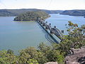
Raising of Warragamba Dam

In May 2017, the New South Wales state government released the Hawkesbury-Nepean Valley Flood Risk Management Strategy, [22] that proposed raising the height of Warragamba Dam by an additional 17 metres, using the Climate Change Mitigation Fund. It was claimed that this would reduce the risk of flooding to homes downstream along the Hawkesbury-Nepean river, that is the most at-risk region of Australia to devastating flooding, exacerbated by Global Warming. [23] A large public opposition campaign culminating in the GIVE A DAM movement began to protect the ecological, historical and Indigenous heritage of the additional area prone to flooding due to the raising of the dam wall. A significant portion of the land to be inundated is located within the Blue Mountains World Heritage Area designated by UNESCO, which stated that this status could be revoked if parts of the world heritage area were to be submerged.[ citation needed ] Activists also claim that the raising of the dam wall will give rise to additional developments downstream, which are currently not allowed to build on floodplains with a risk of a one-in-hundred-year flood. They also claim that any raising of the dam wall will be ineffective at flood mitigation, as the Warragamba River only contributes around 15% of water volume to the Hawkesbury-Nepean system. This issue has again been raised after the March 2021 Australian floods, with government ministers disagreeing on what needs to be done. [24] [25]

Windsor Bridge Replacement

Plans to replace the Windsor Bridge, and direct traffic through the historic Thompson Square caused significant community opposition culminating in the Community Action for Windsor Bridge (CAWB) movement. Despite this opposition, work on the replacement bridge was completed in May 2020. [26]

Third Crossing

Plans for a third crossing at Navua Reserve in Yarramundi, and at North Richmond, 50 metres from the current Richmond Bridge Site are causing public opposition. Activists do not believe that these bridges will alleviate traffic, citing that a North Richmond and Richmond by-pass is required.[ citation needed ]

River usage

Hawkesbury River Marina 2007 0817klklk0037.JPG
Hawkesbury River Marina
A seaplane on the Hawkesbury River A seaplane on the Hawkesbury River.jpg
A seaplane on the Hawkesbury River

The Hawkesbury River is navigable from Windsor to the sea. There are no dams or locks on the river, and the effects of the tide are felt as far as Windsor. [27]

Whilst use of the river to carry farm produce and other goods has now largely been superseded by road transport, the river remains the only form of access to a significant number of isolated homes and communities. This is especially true in the lower reaches of the river, where the steep and rugged terrain inhibits road construction. One consequence of this is the operation of Australia's last riverboat postman, a river service that delivers mail to properties on the river between Brooklyn and Spencer. [28]

Sporting activities

The Hawkesbury Canoe Classic, a 111 km canoe race, is held annually in October or November. The race starts at Windsor and finishes at Brooklyn. The Bridge to Bridge is a water ski race that is run in the opposite direction, from Dangar Island to Windsor. [29] [30] The Australian leg of the Red Bull Cliff Diving World Series takes place in Hawkesbury. Windsor and also Dargle ski park on the Hawkesbury river each year hold a Circuit Boat race meeting with boats travelling from all over country

Commercial fishing

According to the Hawkesbury Nepean Catchment Management Authority, the Hawkesbury River estuary supports the second-largest commercial coastal fishery of estuary prawns, oysters (prior to the outbreak of QX disease) and fish in New South Wales, with a wholesale value of $6.3 million annually. [31]

Cultural references

Hawkesbury River by William Piguenit (1881) William Charles Piguenit00.jpg
Hawkesbury River by William Piguenit (1881)

See also

Related Research Articles

<span class="mw-page-title-main">Warragamba Dam</span> Dam in Warragamba, New South Wales

Warragamba Dam is a heritage-listed dam in the outer South Western Sydney suburb of Warragamba, Wollondilly Shire in New South Wales, Australia. It is a concrete gravity dam, which creates Lake Burragorang, the primary reservoir for water supply for the city of Sydney. The dam wall is located approximately 65 kilometres (40 mi) W of Sydney central business district, 4½ km SW of the town of Wallacia, and 1 km NW of the village of Warragamba.

<span class="mw-page-title-main">Lake Burragorang</span> Man-made water supply dammed reservoir in Australia

Lake Burragorang is a man-made reservoir in the lower Blue Mountains of New South Wales, Australia, serving as a major water supply for greater metropolitan Sydney. The dam impounding the lake, the Warragamba Dam, is located approximately 60 kilometres (37 mi) southwest of the Sydney central business district.

<span class="mw-page-title-main">Windsor, New South Wales</span> Suburb of City of Hawkesbury, New South Wales, Australia

Windsor is a historic town in north-west of Sydney, New South Wales, Australia. It is the council seat of the Hawkesbury local government area. The town sits on the Hawkesbury River, enveloped by farmland and Australian bush. Many of the oldest surviving European buildings in Australia are located at Windsor. It is 46 km (29 mi) north-west of the Sydney CBD, on the fringes of urban sprawl.

<span class="mw-page-title-main">Colo River</span> River in New South Wales, Australia

The Colo River, a perennial stream that is part of the Hawkesbury-Nepean catchment, is located in the Central Tablelands of New South Wales, Australia.

<span class="mw-page-title-main">Nepean River</span> River in New South Wales, Australia

Nepean River, is a major perennial river, located in the south-west and west of Sydney, New South Wales, Australia. The Nepean River and its associated mouth, the Hawkesbury River, almost encircles the metropolitan region of Sydney.

<span class="mw-page-title-main">City of Hawkesbury</span> Local government area in New South Wales, Australia

The City of Hawkesbury is a local government area of New South Wales, Australia, the City of Hawkesbury is located on the North and North Western edge of the Greater Sydney area and is adjacent to the Sydney metropolitan area, about 50 kilometres (31 mi) north-west of the Sydney central business district. Hawkesbury City is named after the Hawkesbury River.

<span class="mw-page-title-main">Wollondilly River</span> River in Australia

The Wollondilly River, an Australian perennial river that is part of the Hawkesbury–Nepean catchment, is located in the Southern Tablelands and Southern Highlands regions of New South Wales. The river meanders from its western slopes near Crookwell, flowing south-east through Goulburn, turning north-east to near Bullio, flowing north-west to Barrallier, before finally heading north-easterly into its mouth at Lake Burragorang.

<span class="mw-page-title-main">Sackville North, New South Wales</span> Suburb of Sydney, New South Wales, Australia

Sackville North is a suburb of Sydney, in the state of New South Wales, Australia 80 kilometres north-west of the Sydney central business district in the local government area of The Hills Shire.

<span class="mw-page-title-main">Berowra Creek</span> River in New South Wales, Australia

The Berowra Creek, a watercourse that is part of the Hawkesbury-Nepean catchment, is located to the north of the Sydney central business district in the Hornsby Shire of New South Wales, Australia.

<span class="mw-page-title-main">Coxs River</span> River in New South Wales, Australia

The Coxs River, a perennial river that is part of the Hawkesbury-Nepean catchment, is located in the Central Tablelands, Blue Mountains, and Macarthur regions of New South Wales, Australia.

<span class="mw-page-title-main">Dangar Island</span> Suburb of Sydney, New South Wales, Australia

Dangar Island is a forested island, 30.8 hectares in area, in the Hawkesbury River, on the northern outskirts of Sydney, New South Wales, Australia. Dangar Island is a suburb of Hornsby Shire and as at the 2016 census had a population of 303, which swells dramatically during holiday seasons. The island is serviced regularly by Brooklyn Ferry Service and departs from Brooklyn and takes about fifteen minutes. The Brooklyn ferry is itself adjacent to Hawkesbury River railway station. The ferry service is in operation 7 days a week.

<span class="mw-page-title-main">Sackville, New South Wales</span> Suburb of City of Hawkesbury, New South Wales, Australia

Sackville (Doorumbolooa) is a suburb of Sydney, in the state of New South Wales, Australia. It is located in the City of Hawkesbury and at the 2016 census had a population of 298, thirteen of whom identified as Aboriginal and Torres Strait Islander.

<span class="mw-page-title-main">1998 Sydney water crisis</span> Water contamination event in Sydney, Australia

The 1998 Sydney water crisis involved the suspected contamination of the water supply system of Greater Metropolitan Sydney by the microscopic pathogens Cryptosporidium and Giardia between July and September 1998.

<span class="mw-page-title-main">Avon River (Wollongong)</span> River in the Southern Highlands and Macarthur districts of New South Wales, Australia

The Avon River, a perennial river of the Hawkesbury-Nepean catchment, is located in the Southern Highlands and Macarthur districts of New South Wales, Australia.

<span class="mw-page-title-main">Warragamba River</span> River in New South Wales, Australia

The Warragamba River, a river that is part of the Hawkesbury-Nepean catchment, is located in the Macarthur region of New South Wales, Australia.

<span class="mw-page-title-main">Hawkesbury and Nepean Wars</span> Australian frontier conflict

The Hawkesbury and Nepean Wars (1794–1816) were a series of conflicts where British forces, including armed settlers and detachments of the British Army in Australia, fought against Indigenous clans inhabiting the Hawkesbury River region and the surrounding areas to the west of Sydney. The wars began in 1794, when the British started to construct farms along the river, some of which were established by soldiers.

<span class="mw-page-title-main">Windsor Bridge (New South Wales)</span> Bridge in Sydney, New South Wales, Australia

The Windsor Bridge, officially called the Hawkesbury River Bridge, Windsor, a beam bridge across the Hawkesbury River, is located in Windsor in north-western Sydney, New South Wales, Australia. The bridge was built in 1874. On 18 May 2020, the replacement bridge was opened to traffic within Windsor, NSW.

<span class="mw-page-title-main">2021 eastern Australia floods</span> Series of disastrous floods in Australia

Extreme rainfall on the east coast of Australia beginning on 18 March 2021 led to widespread flooding in New South Wales, affecting regions from the North Coast to the Sydney metropolitan area in the south. Suburbs of Sydney experienced the worst flooding in 60 years, and the events were described by NSW Premier Gladys Berejiklian as "one in 100-year" flooding. Far-southeast communities in Queensland were also affected by flooding and heavy rainfall, though to a lesser extent than those in New South Wales.

<span class="mw-page-title-main">2022 eastern Australia floods</span> February-April 2022 disaster in New South Wales and Queensland

The 2022 eastern Australia floods were one of the nation's worst recorded flood disasters with a series of floods that occurred from late February to early May in South East Queensland, the Wide Bay–Burnett and parts of coastal New South Wales. Brisbane suffered major flooding, along with the cities of Maryborough, Gympie, the Sunshine Coast, Caboolture, Toowoomba, Gatton, Ipswich, Logan City, the Gold Coast, Murwillumbah, Mullumbimby, Grafton, Byron Bay, Ballina, Lismore, the Central Coast and parts of Sydney.

<span class="mw-page-title-main">2022 New South Wales floods</span> July disaster in New South Wales

Heavy flooding broke out in the Central Coast and Sydney areas of New South Wales, Australia, beginning in early July 2022. Around 85,000 people were displaced by the flooding or requested to leave their homes by authorities. The floods' damage was significant because rain fell on land that was already saturated after months of previous heavy rainfall. It was the third major flood in 2022 for some areas in the eastern seaboard.

References

  1. "East Coastal Watersheds".
  2. Bear, Virginia (2010). "Aboriginal People of the Sydney Region". Australian Association of Bush Regenerators. Retrieved 27 December 2012.
  3. 1 2 "Darkiñung Recognition" (PDF). University of Sydney. 2012. Retrieved 23 September 2012.
  4. 1 2 McGarvie, John (1847), Reverend John McGarvie papers, 1825-1847 , retrieved 21 June 2021
  5. Karskens, Grace. "Life and death on Dyarubbin". Griffith Review . Archived from the original on 24 June 2021. Retrieved 21 June 2021.
  6. Rescue in floodwaters on Hawkesbury River averts collision between shipping container and houseboats ABC News 23 July 2021
  7. New South Wales. Department of Lands. (1953), "1 map : col. ; 73 x 102 cm., on sheet 76 x 105 cm.", Map of the Hawkesbury River from Windsor to Broken Bay including tributaries, also embracing Brisbane Water, Pitt Water, Ku-Ring-Gai Chase, Terrigal and Tuggerah Lakes entrance, New South Wales, Australia (7th ed.), Sydney: The Department, nla.obj-232998574, retrieved 23 June 2021 via Trove
  8. 1 2 "Hawkesbury River". Geographical Names Register (GNR) of NSW. Geographical Names Board of New South Wales . Retrieved 19 December 2008. OOjs UI icon edit-ltr-progressive.svg
  9. "McGarvie's list and Aboriginal Dyarubbin | The Dictionary of Sydney". dictionaryofsydney.org. Retrieved 21 June 2021.
  10. "Real Secret River: Dyarubbin project | The Dictionary of Sydney". dictionaryofsydney.org. Retrieved 21 June 2021.
  11. State Library of New South Wales, Sydney (12 November 2019). "Exploring Dyarubbin". State Library of NSW. Archived from the original on 27 July 2021. Retrieved 8 July 2021.
  12. "The River System, Geographical Outline". The Sydney Morning Herald. p. 7. Retrieved 6 August 2011.
  13. Power, Julie (26 March 2021). "Putting Aboriginal names and places back on the map starts by the river". The Sydney Morning Herald. Retrieved 30 June 2021.
  14. Connor, John (2002). The Australian frontier wars, 1788–1838. Sydney: UNSW Press. ISBN   0-86840-756-9.
  15. Ryan, Lyndall (June 2013). "Untangling Aboriginal resistance and the settler punitive expedition: the Hawkesbury River frontier in New South Wales, 1794–1810". Journal of Genocide Research. 15 (2): 219–232. doi:10.1080/14623528.2013.789206. ISSN   1462-3528. S2CID   108777720.
  16. Macken, James J. Martin Burke: The Father of Pittwater. National Library of Australia.
  17. "Sackville Ferry". New South Wales Roads and Traffic Authority. Archived from the original on 25 August 2006. Retrieved 18 November 2008.
  18. Purtell, Jean (1995). The Mosquito Fleet: Hawkesbury River Trade and Traders 1794-1994.
  19. "Sackville". Windsor and Richmond Gazette . Vol. 6, no. 279. New South Wales, Australia. 11 November 1893. p. 8. Retrieved 30 June 2021 via National Library of Australia.
  20. "Hawkesbury River". National Museum of Australia. Archived from the original on 28 September 2007.
  21. "Conflict at the Hawkesbury". National Museum of Australia. Archived from the original on 28 September 2007.
  22. "Hawkesbury-Nepean Valley Flood Risk Management Strategy". Infrastructure New South Wales.
  23. "Climate change in the Hawkesbury Nepean Catchment" (PDF). CSIRO.
  24. NSW government ministers in stoush over Warragamba Dam management amid flooding by Antonette Collins from ABC News. 21 March 2021
  25. Bitter dispute between NSW ministers over Warragamba Dam spilling by Alexandra Smith from The Sydney Morning Herald. 21 March 2021.
  26. New Windsor Bridge Transport for NSW - Roads and Maritime
  27. "Hawkesbury River - Windsor Tide Times". www.tide-times.com.au. Archived from the original on 31 July 2008. Retrieved 19 December 2008.
  28. "Australia's last Riverboat Postman". Hawkesbury River Tourist Services Pty Ltd. Retrieved 19 December 2008.
  29. "Hawkesbury Canoe Classic". Hawkesbury Canoe Classic. Retrieved 19 December 2008.
  30. "Bridge to Bridge Ski Race". NSW Water Ski Federation. Archived from the original on 19 July 2008. Retrieved 19 December 2008.
  31. "Hawkesbury River Subcatchment". Hawkesbury Nepean Catchment Management Authority. Retrieved 5 January 2007.