
Arncliffe is a suburb in southern Sydney, in the state of New South Wales, Australia. Arncliffe is located 11 kilometres south of the Sydney central business district, in the local government area of the Bayside Council.
Southern Sydney is the southern metropolitan area of Greater Sydney, in the state of New South Wales, Australia.

The Division of Barton is an Australian electoral division in the state of New South Wales.

The St George region of Sydney is part of the southern suburbs of Sydney, in the state of New South Wales, Australia. The area includes all the suburbs in the local government area of Georges River Council and the part of Bayside Council which was Rockdale City prior to 2016. This is everything within the boundaries of Salt Pan Creek to the west, The Georges River to the south, Botany Bay to the east and the M5 Motorway and Wolli Creek to the north. This area corresponds to the southern portion of the cadastral Parish of St George, from which the region derives its name and the area was later covered by the St George County Council, the electricity supplier for the councils in this region. This southern portion of the parish below The M5 and Wolli Creek is the more contemporary definition of The St George Region that is considered part of Southern Sydney.
Undercliffe is an eastern section of the suburb of Earlwood located in South Western Sydney, New South Wales, Australia. Undercliffe is situated 10 kilometres south-west of the Sydney central business district within the local government area of the City of Canterbury-Bankstown.
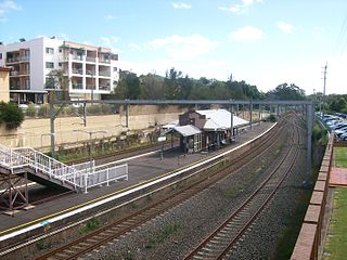
Bardwell Park railway station is a heritage-listed railway station located on the East Hills line, serving the Sydney suburb of Bardwell Park. It is served by Sydney Trains' T8 Airport & South Line services.
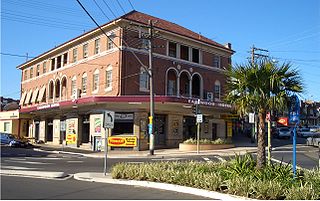
Turrella (;) is a suburb in southern Sydney, in the state of New South Wales, Australia. Turrella is located 10 km south-west of the Sydney central business district on the southern bank of Wolli Creek in the local government area of Bayside Council.

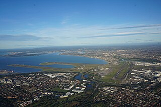
Wolli Creek is a suburb in southern Sydney, in the state of New South Wales, Australia. It sits beside the Wolli Creek and Cooks River waterways. Wolli Creek is situated between the suburbs of Arncliffe and Tempe, 10 kilometres south of the Sydney central business district and is part of the St George area. Wolli Creek is in the local government area of Bayside Council.

Wolli Creek is an urban watercourse of the Cooks River catchment located in the southern suburbs of Sydney, in New South Wales, Australia.

The Cooks River, a semi-mature tide-dominated drowned valley estuary, is a tributary of Botany Bay, located in south-western Sydney, New South Wales, Australia.
Earlwood is a suburb of Sydney, in the state of New South Wales, Australia. Earlwood is located 10 kilometres south-west of the Sydney central business district, and is part of the Canterbury-Bankstown area. It is in the local government area of the City of Canterbury-Bankstown.

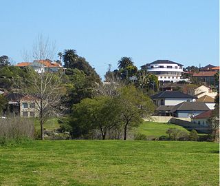
Bardwell Park is a suburb in southern Sydney, in the state of New South Wales, Australia. The suburb is located 12 kilometres south-west of the Sydney central business district and is part of the St George area. Bardwell Park is in the local government area of the Bayside Council. Bardwell Valley is a separate suburb, to the east.

Bexley is a suburb in southern Sydney, in the state of New South Wales, Australia. Bexley is located 14 kilometres (8.7 mi) south-west of the Sydney central business district, in the local government area of the Bayside Council and is part of the St George area.

Bardwell Valley is a suburb in southern Sydney, in the state of New South Wales, Australia. Bardwell Valley is located approximately 11 kilometres south-west of the Sydney central business district, in the local government area of the Bayside Council and is part of the St George area.

Rockdale is an electoral district of the Legislative Assembly in the Australian state of New South Wales.

Cup and Saucer Creek, an urban watercourse of the Cooks River catchment, is located in the Canterbury-Bankstown region of Sydney, in New South Wales, Australia.

The Wolli Creek Regional Park is a 50 hectares regional park, located adjacent to Wolli Creek within the Wolli Creek Valley, between Bexley North and Tempe in south-west Sydney, New South Wales, Australia.

Bayside Council is a local government area in Sydney, New South Wales, Australia. It is located around part of Botany Bay, 7 kilometres (4.3 mi) to 12 kilometres (7.5 mi) south of the Sydney CBD. It includes suburbs of Southern Sydney as well as a portion in the Eastern Suburbs. It comprises an area of 50 square kilometres (19 sq mi) and as at the 2016 census had a population of 156,058.

The Wolli Creek Aqueduct is a heritage-listed sewage aqueduct located at Unwin Street, Earlwood, City of Canterbury-Bankstown, New South Wales, Australia.

