Homebush Bay

Last updated

Homebush Bay
Sydney,  New South Wales
Homebush Bay - SS Ayrfield.jpg
The hull of SS Ayrfield in Homebush Bay
Homebush Bay
Postcode(s) 2127
Location13 km (8 mi) west of Sydney CBD
LGA(s)
State electorate(s)
Federal division(s) Reid
Suburbs around Homebush Bay:
Melrose Park Meadowbank Rhodes
Wentworth Point Homebush Bay Liberty Grove
Sydney Olympic Park Sydney Olympic Park North Strathfield
Former quarry, Sydney Olympic Park Former quarry at olympic park sydney.jpg
Former quarry, Sydney Olympic Park

Homebush Bay is a bay on the south bank of the Parramatta River, in the west of Sydney, Australia. The name is also sometimes used to refer to an area to the west and south of the bay itself, which was formerly an official suburb of Sydney, and has now become the suburbs of Sydney Olympic Park, Wentworth Point and part of the neighbouring suburb of Lidcombe, all part of the City of Parramatta. Homebush Bay is located 13 kilometres (8.1 mi) west of the Sydney central business district.

Contents

The bay has natural and artificial shoreline on the southern side of the Parramatta River between the suburb of Wentworth Point and the suburb of Rhodes. The bay was contaminated with dioxin and other chemicals by Union Carbide group which led to commercial fishing bans in most of Sydney Harbour and health advisories about limiting the quantity of fish eaten from the Parramatta River. Fishing is prohibited in Homebush Bay for health reasons. Other contamination includes phthalates, lead, polycyclic aromatic hydrocarbons, DDT and heavy metals. [1] The eastern shore of the bay was remediated starting in 2008 to remove about 75% of the dioxin from the bay. Remediation was completed in mid-2010.

The western shore of Homebush Bay is in the local government area of the City of Parramatta, while its eastern shore is in the City of Canada Bay. As a result, the bay forms part of the geographical boundary between the Greater Western Sydney region in the west, and the Inner West region of Sydney in the east, [2] except that the suburb of Wentworth Point, at the northern tip of the western bank, is sometimes marketed as being in the Inner West. [3]

Homebush and Homebush West are separate suburbs to the south, in the Municipality of Strathfield.

History

The region is a part of the traditional land of the Wann-gal people who lived in Homebush Bay thousands of years ago and survived on the resources offered by the estuary. The first European settlers arrived here in 1793 and declared the land as 'Flats' whose grants were given to free men. For this reason, it came to be known as the 'Liberty Plains'. The land was dominated by two families during this period - the Blaxlands and the Wentworths. [4]

The Home Bush Estate was established in the 1800s by the colony's assistant surgeon D'arcy Wentworth. [5] According to local government historian Michael Jones, "Wentworth is popularly credited with having called the area after his 'home in the bush', although Homebush is also a place in Kent." [6] The Wentworth family's estate lay on the southwestern shore of the bay, between Powell's Creek and Haslam's Creek, and south to Parramatta Road. Further to the northwest, to the west of Haslam's Creek, the Blaxland family owned the Newington Estate. The bay took its name from the Home Bush Estate. When the railway came through the area south of Parramatta Road in 1855, a station was built in the area to serve the racecourse on the Wentworth estate, and took its name ("Homebush") from the estate also. The village and later suburb that developed to the south of - and later the north of - the railway station took its name from the station, and is today partly in the suburb of Homebush and partly in the suburb of Strathfield. Meanwhile, the Home Bush Estate became part of the Municipality of Rookwood in 1891, renamed Lidcombe in 1906. Thereafter, it was part of the suburb of Lidcombe and known as "North Lidcombe". In 1989, North Lidcombe was renamed "Homebush Bay". [7] This history of name borrowing has resulted in the names "Homebush Bay" and "Homebush" being used at various times for a large and disparate area ranging from modern-day Wentworth Point in the City of Parramatta, to the seat of the Municipality of Strathfield in modern-day Strathfield, almost 6km away.

In the 20th century, Homebush Bay became a centre of heavy industry, with large scale land reclamations to accommodate industrial facilities. When industrial operations scaled down, the bay became a dumping ground for a large range of unwanted material - from waste to broken up ships, even toxic industrial waste. Union Carbide had manufactured chemicals, including Agent Orange, on the site and dioxins produced as a by product were buried in landfill or left in drums. [8]

A drive to regenerate and rehabilitate the bay began in the 1980s. This led to the construction of Bicentennial Park, including a program to regenerate some of the mangrove wetlands and saltmarshes which existed around the bay pre-development. In preparation for the 2000 Sydney Olympics, it was decided to site Sydney Olympic Park at Homebush Bay, which spurred the further regeneration and rehabilitation of the bay. A range of residential and commercial developments also began around the bay, including the development of a large shopping centre and residential district at Rhodes on the eastern shore.

Suburb name change

The former Auburn Council sought public comment on a proposal to rename the suburb of Homebush Bay, as well as removing connotations and confusion with its namesake suburb Homebush. The waterfront residential area was renamed Wentworth Point on 2 October 2009, [9] consistent with the gazetting of the northern part of the peninsula in 1976. [10] the Carter Street industrial precinct was absorbed by the neighbouring suburb of Lidcombe, and the remaining bulk of the suburb, consisting of Sydney Olympic Park, was renamed to that name as a suburb.

Hydrography

Homebush Bay, aerial view east towards Rhodes. Rhodes Liberty Grove Concord West.jpg
Homebush Bay, aerial view east towards Rhodes.
Multilingual sign warning against fishing in the bay. RhodesNoFishingWarning.JPG
Multilingual sign warning against fishing in the bay.
The Brickpit, former industrial site now providing wetland habitat for local fauna. Ringwalk...jpg
The Brickpit, former industrial site now providing wetland habitat for local fauna.

Homebush Bay is located on the southern shore of Parramatta River. Immediately to the east is Bray Bay, which is separated from Homebush Bay by a narrow peninsula (considerably expanded through land reclamation) that forms the suburb of Rhodes. It is across the Parramatta River from Meadowbank. It is the westernmost of the major bays on the Parramatta River.

Several tributaries enter Parramatta River at Homebush Bay: Powells Creek is joined by tributaries Boundary Creek and Saleyards Creek not far from the southern shore of the bay, and flows into the bay from the south, while Haslams Creek joins the bay further to the north.

The shoreline of Homebush Bay is in large parts artificial, with large scale land reclamations for industrial purposes occurring throughout the 20th century. Its history of use for industry and as dumping ground has left the bay heavily contaminated, including with dioxin and other chemicals produced by Union Carbide operations. Fishing is prohibited in Homebush Bay for health reasons. Other contamination includes phthalates, lead, polycyclic aromatic hydrocarbons, DDT and heavy metals. [11] Remediation from 2008-2010 removed about 75% of the dioxin from the bay.

A number of ships' hulls are visible in Homebush Bay, remains of the ship-breaking operations in the bay during the mid-20th century. These are the steam colliers SS Ayrfield and SS Mortlake Bank, steam tugboat SS Heroic, and boom defence vessel HMAS Karangi, all broken up in the early 1970s and now lying near the south-western shore of the bay. Remains of a number of smaller abandoned or broken up vessel lie nearby. [12]

Landmarks

Bicentennial Park Bicentennial Park 12.JPG
Bicentennial Park
Water fountain in the Sydney Olympic Park Water fountain olympic park new south wales.jpg
Water fountain in the Sydney Olympic Park

Bicentennial Park is located on the southern shore of the bay, and contains an area of rehabilitated mangrove wetland representative of the native state of the bay.

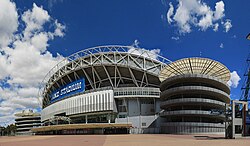
Sydney Olympic Park is a 640 hectares (1,600 acres) area to the south west of Homebush Bay (and within the former suburb of Homebush Bay) which was notable as the site of the 2000 Olympic Games. Since then, there has been much development in the area including office buildings and apartments in the centre of Sydney Olympic Park. Three completed residential developments in the area are Newington, The Waterfront and Mariners Cove.

The Sydney Showground relocated from Moore Park in 1998, in preparation for the Olympic Games. The Sydney Showground provided Olympic venues along with Stadium Australia, Sydney Super Dome, Athletics Centre, Aquatic Centre, Tennis Centre, Hockey Stadium and multiple sports halls.

On the eastern shore, within the suburb of Rhodes, lies the large Rhodes Waterside shopping centre.

The Novotel Hotel features cafes, restaurants and bars with outdoor facilities that cater for special events held at Sydney Olympic Park.

Bennelong Bridge, a bridge open to pedestrians, cyclists and buses but not to cars, crosses the bay near its mouth (between Rhodes on the east bank and Wentworth Point on the west bank). The bridge opened on 22 May 2016. Between 2014 and 2016, during construction, the low bridge was protected by a "maritime exclusion zone", meaning that watercraft was not able to enter or leave Homebush Bay. [13]

Transport

Olympic Park railway station Sydney Olympic Park railway station 2.JPG
Olympic Park railway station

Two stations on the Sydney Trains metropolitan passenger rail network sit near the shores of the bay. To the south-west, Olympic Park railway station was built to cater for large crowds to the precinct during the 2000 Sydney Olympics, and is especially heavily used for special events in the Olympic Park precinct. It is serviced by a shuttle connecting Olympic Park to Lidcombe railway station. On the eastern shore, Rhodes railway station is on the T9 Northern line.

Sydney Ferries' Parramatta River ferry services run to the Sydney Olympic Park ferry wharf on the bay. Originally designed to service Sydney Olympic Park, the wharf now mainly serves the residents of Wentworth Point. Busways run a number of regular bus services to the area around the bay. There are also a number of Sydney Olympic Park bus routes for sporting events, concerts and other major events at the Sydney Olympic Park precinct such as the Sydney Royal Easter Show.

A light rail line is planned to be constructed on the western shore of the bay, which will connect Olympic Park railway station with the centre of Parramatta, to the west. The line was initially planned to run alongside the parkland on the southern shore and connect with Strathfield railway station, but in the current plans the line will terminate at Sydney Olympic Park.

Culture

Events

Sport

Stadium Australia 2.jpg

For more information see Stadium Australia

Pop culture

The Brickpit at Sydney Olympic Park was used as a location for the filming of Mad Max: Beyond Thunderdome . [14]

See also

Related Research Articles

Rhodes, New South Wales Suburb of Sydney, New South Wales, Australia

Rhodes is an Inner West suburb of Sydney, in the state of New South Wales, Australia. Rhodes is located 12 kilometres west of the Sydney central business district, in the local government area of the City of Canada Bay. It was formerly part of Concord Municipality until a merger with Drummoyne Council to form Canada Bay in December 2000.

Parramatta River River in Australia

The Parramatta River is an intermediate tide-dominated, drowned valley estuary located in Sydney, New South Wales, Australia. With an average depth of 5.1 metres (17 ft), the Parramatta River is the main tributary of Sydney Harbour, a branch of Port Jackson. Secondary tributaries include the smaller Lane Cove and Duck rivers.

Homebush, New South Wales Suburb of Sydney, New South Wales, Australia

Homebush is a suburb in the Inner West of Sydney in the state of New South Wales, Australia. It is located 12 kilometres west of the Sydney central business district, in the local government area of the Municipality of Strathfield.

Municipality of Strathfield Local government area in New South Wales, Australia

The Municipality of Strathfield, also known as Strathfield Council, is a local government area in the Inner West of Sydney, in the state of New South Wales, Australia.

Inner West Region in New South Wales, Australia

The Inner West of Sydney is an area directly west of the Sydney central business district, New South Wales, Australia. The suburbs that make up the Inner West are predominantly located along the southern shore of Port Jackson, stretching south to the shores of the Cooks River. The western boundary of the Inner West is approximately the A3 arterial road, which divides the Inner West from the Greater Western Sydney region. The Inner West is much larger than the Inner West Council local government area. The Inner West roughly corresponds with the Parish of Petersham and Parish of Concord, two cadastral divisions used for land titles.

A3 (Sydney)

The A3 is a major metropolitan arterial route in Sydney, formerly designated Metroad 3. The A3 runs from its intersection with the A8 at Mona Vale at the north end, to the southerly of its two intersections with the A1, Princes Highway, at Blakehurst. The highest speed limit on the A3 is 90 km/h (56 mph) on Mona Vale Road.

Strathfield, New South Wales Suburb of Sydney, New South Wales, Australia

Strathfield is a suburb in the Inner West of Sydney, in the state of New South Wales, Australia. It is located 12 kilometres west of the Sydney central business district and is the administrative centre of the Municipality of Strathfield. A small section of the suburb north of the railway line lies within the City of Canada Bay, while the area east of The Boulevard lies within the Municipality of Burwood. North Strathfield and Strathfield South are separate suburbs to the north and south, respectively.

Strathfield railway station Railway station in Sydney, New South Wales, Australia

Strathfield railway station is a heritage-listed railway station located on the Main Suburban line in the Sydney suburb of Strathfield in the Municipality of Strathfield local government area of New South Wales, Australia. The station is served by Sydney Trains T1 North Shore & Western Line, T9 Northern Line and T2 Inner West & Leppington Line suburban services as well as NSW TrainLink Intercity and regional services. The station is located on the Main Northern and Main Western railway lines, forming a major junction for regional and suburban rail services. The station and associated infrastructure was added to the New South Wales State Heritage Register on 2 April 1999.

Liberty Grove, New South Wales Suburb of Sydney, New South Wales, Australia

Liberty Grove is a suburb in the Inner West of Sydney, in the state of New South Wales, Australia.

Meadowbank, New South Wales Suburb of Sydney, New South Wales, Australia

Meadowbank is a suburb of Sydney, New South Wales, Australia. Meadowbank is located 15 kilometres north west of the Sydney central business district, in the local government area of the City of Ryde and part of the Northern Sydney region. Meadowbank sits in a valley on the northern bank of the Parramatta River.

Lidcombe Suburb of Sydney, New South Wales, Australia

Lidcombe is a suburb in western Sydney, in the state of New South Wales, Australia. Lidcombe is located 15 km (9.32 mi) west of the Sydney central business district, in the local government area of Cumberland Council, with a small industrial part in the north in the City of Parramatta.

Homebush West Suburb of Sydney, New South Wales, Australia

Homebush West is a suburb in the Inner West of Sydney, in the state of New South Wales, Australia. Homebush West is located 13 kilometres west of the Sydney central business district, in the local government area of the Municipality of Strathfield, with a small unpopulated strip in the northwest in Cumberland Council. The suburb is commonly referred to as Flemington, even in official contexts. This was the old name of the suburb before the establishment of Sydney Markets in 1975. Subsequently, "Flemington" was confined to the area occupied by the markets, whereas the residential part of the suburb was renamed "Homebush West", after the suburb of Homebush immediately to the east. Both the railway station and various organisations and businesses in the suburb still carry the name "Flemington". Homebush Bay was formerly a separate suburbs to the north.

Sydney Olympic Park Suburb of Sydney, New South Wales, Australia

Sydney Olympic Park is a suburb of Greater Western Sydney, located 13 kilometres west of the Sydney central business district, in the local government area of the City of Parramatta Council. It is commonly known as Olympic Park but officially named Sydney Olympic Park. The area was part of the suburb of Lidcombe and known as "North Lidcombe", but between 1989 and 2009 was named "Homebush Bay". The names "Homebush Bay" and, sometimes, "Homebush" are still used colloquially as a metonym for Stadium Australia as well as the Olympic Park precinct as a whole, but Homebush is an older, separate suburb to the southeast, in the Municipality of Strathfield.

Parramatta River ferry services

Parramatta River ferry services connect suburbs along the Parramatta River in Sydney with Circular Quay by commuter ferry. The services are numbered F3 and form part of the Sydney Ferries network.

Bicentennial Park, Sydney Olympic Park

Bicentennial Park is a 40-hectare (99-acre) suburban parkland located 16 kilometres (9.9 mi) west of the Sydney central business district in the suburb of Sydney Olympic Park, in the local government area of City of Parramatta, New South Wales, Australia. Bicentennial Park is situated on the shores of Homebush Bay and is a part of the Sydney Olympic Park. The park is a natural heritage site featuring an important wetland ecosystem and parklands.

Powells Creek, a southern tributary of the Parramatta River, is an urban stream west of Sydney Harbour, located in Sydney, Australia. It flows through Sydney Olympic Park and joins Parramatta River at Homebush Bay.

Saleyards Creek is a canalised urban stream, acting as a stormwater channel, located in Sydney, Australia. Its upstream course follows approximately the boundary between the suburbs of Homebush and Homebush West. North of Parramatta Road, both sides of the creek fall within Homebush.

Haslams Creek River in Australia

Haslams Creek, a southern tributary of the Parramatta River, is a creek west of Sydney Harbour, located in Sydney, Australia. It flows through Sydney Olympic Park and joins Parramatta River at Homebush Bay. In 1793, the first grants were made to free settlers, with Samuel Haslam receiving his first grant in 1806. A 50 acre grant north of Parramatta Road, the first grant, was followed by a second small grant south of Parramatta Road and east of Haslams Creek. Haslams Creek flowed through the holdings of the Sydney Meat Preserving Company Ltd 1876-1965, which at one point damned the creek. When opened, Lidcombe railway station actually bore the name Haslams Creek Station

Wentworth Point, New South Wales Suburb of Sydney, New South Wales, Australia

Wentworth Point is a suburb of Sydney, in the state of New South Wales, Australia. It is located 13 kilometres west of the Sydney central business district, on the eastern edge of the local government area of City of Parramatta. It is on the western shore of Homebush Bay on the southern side of the Parramatta River. Wentworth Point is usually regarded as part of the Greater Western Sydney region, including in administrative contexts, but it is also regarded as part of the Inner West region of Sydney in some contexts, especially commercial contexts.

Bennelong Bridge Bridge in New South Wales, Australia

The Bennelong Bridge is a 330-metre-long (1,080 ft) vehicular bridge across Homebush Bay between the Sydney suburbs of Rhodes and Wentworth Point. It opened on 22 May 2016.

References

  1. "Home - Homebush Bay Remediation". Archived from the original on 21 February 2012. Retrieved 31 October 2011.
  2. Centre for Western Sydney - About the profile area
  3. Domain - Wentworth Point Suburb Profile
  4. "Sydney Olympic Park and Homebush Bay – A Brief History". Parramatta Heritage Centre.
  5. The Book of Sydney Suburbs, Compiled by Frances Pollon, Angus & Robertson Publishers, 1990, Published in Australia ISBN   0-207-14495-8, page 124
  6. Jones, Michael (1985). Oasis in the West: Strathfield's first hundred years. North Sydney: Allen & Unwin Australia. ISBN   0-86861-407-6, page 15
  7. Dictionary of Sydney - Homebush Bay
  8. Perry, Michael (10 February 2006). "Toxic Waste Ends Sydney Harbour Commercial Fishing". Reuters, Planet Ark. Archived from the original on 20 June 2006. Retrieved 13 April 2007.
  9. "Auburn Council". Archived from the original on 13 October 2009. Retrieved 6 October 2009.
  10. Leaflet, A New Suburb Name For Homebush Bay
  11. "Home - Homebush Bay Remediation". Archived from the original on 21 February 2012. Retrieved 31 October 2011.
  12. Blaxell, Gregory (May 2008). "The Wrecks of Homebush Bay". Afloat. AFLOAT Publications Pty. Ltd. Archived from the original on 5 May 2013. Retrieved 30 April 2013.
  13. A new bridge to connect growing communities Homebush Bay Bridge
  14. Bartertown Set for Mad Max: Beyond Thunderdome

Coordinates: 33°49′43″S151°04′51″E / 33.82870°S 151.08088°E / -33.82870; 151.08088