
The Georges River, also known as Tucoerah River, is an intermediate tide-dominated drowned valley estuary, located to the south and west of Sydney, New South Wales, Australia.

The Parramatta River is an intermediate tide-dominated, drowned valley estuary located in Sydney, New South Wales, Australia. With an average depth of 5.1 metres (17 ft), the Parramatta River is the main tributary of Sydney Harbour, a branch of Port Jackson. Secondary tributaries include the smaller Lane Cove and Duck rivers.

The Inner West of Sydney is an area directly west of the Sydney central business district, New South Wales, Australia. The suburbs that make up the Inner West are predominantly located along the southern shore of Port Jackson, stretching south to the shores of the Cooks River. The western boundary of the Inner West is approximately the A3 arterial road, which divides the Inner West from the Greater Western Sydney region. The Inner West is much larger than the Inner West Council local government area. The Inner West roughly corresponds with the Parish of Petersham and Parish of Concord, two cadastral divisions used for land titles.

North Rocks is a suburb in the Hills District within Greater Western Sydney, in the state of New South Wales, Australia, located 26 kilometres north-west of the Sydney central business district. Following the amalgamation of council areas in 2016, the majority of North Rocks falls into the council area of the City of Parramatta. Streets north of the M2 Hills Motorway are within The Hills Shire.

Middle Harbour, a semi–mature tide dominated drowned valley estuary, is the northern arm of Port Jackson, an inlet of the Tasman Sea located north of Sydney central business district on the coast of New South Wales, Australia.

Greater Western Sydney (GWS) is a large region of the metropolitan area of Greater Sydney, New South Wales (NSW), Australia that generally embraces the north-west, south-west, central-west, and far western sub-regions within Sydney's metropolitan area and encompasses 13 local government areas: Blacktown, Blue Mountains, Camden, Campbelltown, Canterbury-Bankstown, Cumberland, Fairfield, Hawkesbury, Hills Shire, Liverpool, Parramatta, Penrith and Wollondilly. It includes Western Sydney, which has a number of different definitions, although the one consistently used is the region composed of ten local government authorities, most of which are members of the Western Sydney Regional Organisation of Councils (WSROC). Penrith, Hills Shire & Canterbury-Bankstown are not WSROC members. The NSW Government's Office of Western Sydney calls the region "Greater Western Sydney".

The Darug or Dharug people are an Aboriginal Australian people, who share strong ties of kinship and, in pre-colonial times, lived as skilled hunters in family groups or clans, scattered throughout much of what is modern-day Sydney.

Auburn is a Western Sydney suburb in the state of New South Wales, Australia. Auburn is located 16 kilometres (9.9 mi) west of the Sydney central business district and is in the local government area of Cumberland City Council, having previously been the administrative centre of Auburn Council. The suburb was named after Oliver Goldsmith's poem The Deserted Village, which describes 'Auburn' in England as the "loveliest village of the plain".

The Wangal people are a clan of the Eora Aboriginal people whose heirs are custodians of the lands and waters of what is now the Inner West of Sydney, New South Wales, centred around the Municipality of Strathfield, Municipality of Burwood, City of Canada Bay and former Ashfield Council and extending west into the City of Parramatta.

Camellia is a suburb of Sydney, in the state of New South Wales, Australia. Primarily industrial with no residential population, environmental remediation commenced in late 2015, with the suburb ear-marked as a major centre for future high density living.
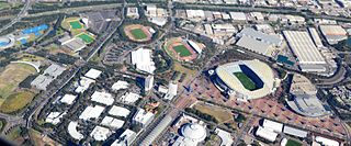
Sydney Olympic Park is a suburb of Greater Western Sydney, located 13 kilometres west of the Sydney central business district, in the local government area of the City of Parramatta Council. It is commonly known as Olympic Park but officially named Sydney Olympic Park. The area was part of the suburb of Lidcombe and known as "North Lidcombe", but between 1989 and 2009 was named "Homebush Bay". The names "Homebush Bay" and, sometimes, "Homebush" are still used colloquially as a metonym for Stadium Australia as well as the Olympic Park precinct as a whole, but Homebush is an older, separate suburb to the southeast, in the Municipality of Strathfield.

Prospect Creek, an urban watercourse of the Georges River catchment, is located in the western and Canterbury-Bankstown regions of Sydney, in New South Wales, Australia.
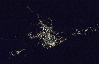
The geography of Sydney is characterised by its coastal location on a basin bordered by the Pacific Ocean to the east, the Blue Mountains to the west, the Hawkesbury River to the north and the Woronora Plateau to the south. Sydney lies on a submergent coastline on the east coast of New South Wales, where the ocean level has risen to flood deep river valleys (rias) carved in the Sydney sandstone. Port Jackson, better known as Sydney Harbour, is one such ria.

The Cumberland Plain, an IBRA biogeographic region, is a relatively flat region lying to the west of Sydney CBD in New South Wales, Australia. Cumberland Basin is the preferred physiographic and geological term for the low-lying plain of the Permian-Triassic Sydney Basin found between Sydney and the Blue Mountains, and it is a structural sub-basin of the Sydney Basin.

Haslams Creek, a southern tributary of the Parramatta River, is a creek west of Sydney Harbour, located in Sydney, Australia. It flows through Sydney Olympic Park and joins Parramatta River at Homebush Bay. In 1793, the first grants were made to free settlers, with Samuel Haslam receiving his first grant in 1806. A 50 acre grant north of Parramatta Road, the first grant, was followed by a second small grant south of Parramatta Road and east of Haslams Creek. Haslams Creek flowed through the holdings of the Sydney Meat Preserving Company Ltd 1876-1965, which at one point damned the creek. When opened, Lidcombe railway station actually bore the name Haslams Creek Station
A'Becketts Creek is a perennial stream and a northern tributary of the Duck River and part of the Parramatta River catchment, in Sydney, New South Wales, Australia.
Ponds/Subiaco Creek, a joint northern tributary of the Parramatta River, is a creek north-west of Sydney Harbour, located in the Northern Suburbs region of Sydney, New South Wales, Australia. The Creek is also known as The Ponds and the Subiaco Creek respectively. It is followed by a walking track known as 'The Ponds Walk'.

Toongabbie Creek, an urban watercourse that is part of the Parramatta River catchment, is located in Greater Western Sydney, New South Wales, Australia.
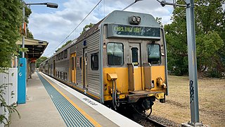
The Carlingford railway line was a railway line in Sydney, Australia. It was opened from Clyde to Subiaco in January 1885, then by means of the construction of a bridge across the Parramatta River, to Carlingford in April 1896. It closed on 5 January 2020 with much of the line to be converted to light rail as part of the Parramatta Light Rail network, while a short section of the line was retained for use by Sydney Trains.
The M4 cycleway is a 15-kilometre-long (9.3 mi) shared use path for cyclists and pedestrians that is generally aligned with the M4 Motorway in Sydney, New South Wales, Australia. The eastern terminus of the cycleway is in Sydney Olympic Park, while the western terminus is in South Wentworthville.


