North Parramatta

Last updated

North Parramatta
New South Wales
Lake Parramatta,New South Wales.jpg
Masonry arch wall at Lake Parramatta
North Parramatta
Population13,248 (2016 census) [1]
 • Density2,548/km2 (6,600/sq mi)
Postcode(s) 2151
Elevation39 m (128 ft)
Area5.2 km2 (2.0 sq mi)
Location24 km (15 mi) north-west of Sydney CBD
LGA(s) City of Parramatta
State electorate(s) Parramatta
Federal division(s) Parramatta
Suburbs around North Parramatta:
Northmead North Rocks Carlingford
Northmead North Parramatta Oatlands
Westmead Parramatta Rydalmere

North Parramatta is a suburb on the North Shore of Sydney, in the state of New South Wales, Australia. North Parramatta is 24 kilometres north-west of the Sydney central business district in the local government area of the City of Parramatta.

Contents

History

The Darug people had lived in the area for many generations, and regarded the area as a food bowl, rich in food from the river and forests. They called the area Baramada or Burramatta ('Parramatta') which means "the place where the eels lie down". [2]

Heritage listings

North Parramatta has a number of heritage-listed sites, including:

The UrbanGrowth NSW Development Corporation is working on creating an aspirational place identity for the publicly owned and nationally listed Heritage Core. It will not have any residential developments, and the heritage buildings will be preserved with the help of repair and restoration work that will make them weatherproof and safe. The significant landmarks on the site which will be conserved include the Cumberland Hospital and the Norma Parker Centre. [5]

Schools and recreation

North Parramatta is dominated by Lake Parramatta and The King's School, which together comprise almost 50% of the land area. Lake Parramatta is a 10-hectare reserve, based around a former reservoir. The catchment area for the lake is bounded by North Rocks Road, Pennant Hills Road and Hunts Creek. The entrance is from Lackey Street, North Parramatta. Lake Parramatta served as a recreational spot for locals who enjoyed swimming. It had been closed due to pollution, but was reopened in January 2015.

Schools in the suburb include:

Transport

The nearest train station to North Parramatta is Parramatta railway station. The 609 bus route, run by Hillsbus, is the local access to bus transport. It circles around from Prince Street, to Gloucester Avenue, past Lake Parramatta, onto Iron Street and then to the Parramatta Bus Interchange.

At the 2011 census, 21.9% of employed people travelled to work on public transport and 57.3% by car (either as driver or as passenger). [1]

Demographics

Historical population
YearPop.±%
20018,710    
20068,365−4.0%
201112,594+50.6%
201613,248+5.2%

At the 2016 census, North Parramatta recorded a population of 13,248. Of these: [1]

Age distribution
North Parramatta has a slight over-representation of young adults when compared to the country as a whole. This is most apparent in the range 25–34 years of age, who make up 20.4% of the suburb's population, significantly larger than the national average of 14.4%. North Parramatta residents' median age was 35 years, compared to the national median of 38. Children aged 0–14 years made up 17.7% of the population (national average is 18.7%) and people aged 65 years and over made up 11.0% of the population (national average is 15.8%).
Ethnic diversity
About half (45.4%) of North Parramatta residents were born in Australia; the next most common countries of birth were India 7.8%, China 5.5%, Iran 3.5%, Philippines 2.5% and Lebanon 2.2%. However, only 13.2% identify their ancestry as Australian, which is the largest group; the next most common self-identified ancestries were English 12.9%, Chinese 9.0%, Indian 7.9% and Irish 5.3%. Just under half (44.1%) of people only spoke English at home; other languages spoken at home included Mandarin 5.7%, Arabic 5.5%, Persian 3.4%, Cantonese 3.2% and Hindi 3.2%.
Religion
The most common responses for religion were Catholic 23.7% and No Religion 21.4%.
Income
The average weekly household income was $1,524, compared to the national average of $1,438.
Housing
Most private dwellings (59.1%) were flats, units or apartments. Another 23.7% were separate houses, while 16.6% were semi-detached (mainly townhouses). The average household size was 2.5 people.

See also

Related Research Articles

<span class="mw-page-title-main">Granville, New South Wales</span> Suburb of Sydney, New South Wales, Australia

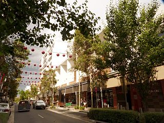
Granville is a suburb in Western Sydney, in the state of New South Wales, Australia. Granville is located 18 kilometres (11 mi) west of the Sydney central business district, split between the local government areas of Cumberland City Council and the City of Parramatta.

<span class="mw-page-title-main">Parramatta</span> City in New South Wales, Australia

Parramatta is a city in Sydney, Australia's largest city and the capital of New South Wales. It is the primary central business district (CBD) for Greater Western Sydney, located approximately 24 kilometres (15 mi) west of Central Sydney, on the banks of the Parramatta River.

<span class="mw-page-title-main">Castle Hill, New South Wales</span> Town in New South Wales, Australia

Castle Hill is a town in Sydney, New South Wales, Australia, located 34 kilometres north-west of the Sydney central business district and 9.5 kilometres north of Parramatta. It is within the Hills District region, split between the local government areas of The Hills Shire and Hornsby Shire.

<span class="mw-page-title-main">Hornsby, New South Wales</span> City in New South Wales, Australia

Hornsby is a city on the Upper North Shore of Sydney in the state of New South Wales, Australia, approximately 23 kilometres (14 mi) north-west of the Sydney central business district. It is the administrative centre of the local government area of Hornsby Shire.

<span class="mw-page-title-main">Ryde, New South Wales</span> Suburb of Sydney, New South Wales, Australia

Ryde is a suburb of Sydney, New South Wales, Australia. Ryde is located 13 km north-west of the Sydney central business district and 8 km east of Parramatta. Ryde is the administrative centre of the local government area of the City of Ryde and part of the Northern Sydney region. It lies on the north bank of the Parramatta River. People from Ryde are colloquially known as Ryders, Rydiens or Rydemen.

<span class="mw-page-title-main">North Rocks, New South Wales</span> Suburb of Greater Western Sydney, New South Wales, Australia

North Rocks is a suburb straddling the Hills District and Parramatta within Greater Western Sydney, in the state of New South Wales, Australia, located 26 kilometres north-west of the Sydney central business district. Following the amalgamation of council areas in 2016, the majority of North Rocks falls into the council area of the City of Parramatta. Streets north of the M2 Hills Motorway are within The Hills Shire.

<span class="mw-page-title-main">Hunters Hill, New South Wales</span> Suburb of Sydney, New South Wales, Australia

Hunters Hill is a suburb of Northern Sydney, in the state of New South Wales, Australia. Hunters Hill is located 9 kilometres (5.6 mi) north-west of the Sydney central business district and is the administrative centre for the local government area of the Municipality of Hunter's Hill.

<span class="mw-page-title-main">Haberfield, New South Wales</span> Suburb of Sydney, New South Wales, Australia

Haberfield is a suburb in the Inner West of Sydney, in the state of New South Wales, Australia. Haberfield is located 6.5 kilometres west of the Sydney central business district in the local government area of the Inner West Council.

<span class="mw-page-title-main">Killara</span> Suburb of Sydney, New South Wales, Australia

Killara is a suburb on the Upper North Shore of Sydney in the state of New South Wales, Australia 14 kilometres (8.7 mi) north-west of the Sydney central business district in the local government area of Ku-ring-gai Council. East Killara is a separate suburb and West Killara is a locality within Killara.

<span class="mw-page-title-main">North Epping, New South Wales</span> Suburb of Sydney, New South Wales, Australia

North Epping is a suburb of Sydney, in the state of New South Wales, Australia 19 kilometres north-west of the Sydney central business district in the local government area of Hornsby Shire. North Epping is in the Northern Sydney region, and is often referred to as part of the "North-West" or North Shore. Epping is a separate suburb to the south and under the Parramatta City Council, which shares the postcode of 2121.

<span class="mw-page-title-main">Eastwood, New South Wales</span> Suburb of Sydney, New South Wales, Australia

Eastwood is a suburb of Sydney, Australia. Eastwood is located 17 kilometres north-west of the Sydney central business district in the local government areas of the City of Ryde and the City of Parramatta. Eastwood is in the Northern Sydney region and is on the Sydney Trains Northern Line (Sydney). despite it being partially in the City of Parramatta. The area is best known for being an ethnic enclave for immigrant populations in Sydney, mainly of East Asian origin but the suburb also has a significant number of other immigrant populations, such as Italian and Anglo-Saxon people. Eastwood was originally its own town but due to the expansion of Sydney, was eventually absorbed.

Dundas is a suburb of Sydney, New South Wales, Australia. Dundas is located 21 kilometres north-west of the Sydney central business district, in the local government area of the City of Parramatta, and the electoral division of Bennelong. Dundas is a leafy green suburb, notably due to its centrepiece The Ponds Walk, which follows the Ponds Subiaco Creek. Dundas is part of the Northern Sydney and Greater Western Sydney regions.

<span class="mw-page-title-main">Burwood, New South Wales</span> Suburb of Sydney, New South Wales, Australia

Burwood is a suburb in the Inner West of Sydney, in the state of New South Wales, Australia. It is 10 kilometres (6.2 mi) west of the Sydney central business district and is the administrative centre for the local government area of Municipality of Burwood.

<span class="mw-page-title-main">Cremorne, New South Wales</span> Suburb of Sydney, New South Wales, Australia

Cremorne is a suburb on the Lower North Shore of Sydney, New South Wales, Australia, located 6 kilometres north-east of the Sydney central business district, in the local government area of North Sydney Council.

<span class="mw-page-title-main">Gladesville</span> Suburb of Sydney, New South Wales, Australia

Gladesville is a suburb in the Lower North Shore of Sydney, in the state of New South Wales, Australia. Gladesville is located 10 kilometres north-west of the Sydney central business district, in the local government area of the City of Ryde and the Municipality of Hunter's Hill. Gladesville is part of the federal electorates of North Sydney and Bennelong.

<span class="mw-page-title-main">Telopea, New South Wales</span> Suburb of Sydney, New South Wales, Australia

Telopea is a suburb of Greater Western Sydney, in the state of New South Wales, Australia. Telopea is located 23 kilometres north-west of the Sydney central business district, in the local government area of the City of Parramatta. The suburb is bordered by Kissing Point Road to the south and Pennant Hills Road to the north.

<span class="mw-page-title-main">Silverwater</span> Suburb of Sydney, New South Wales, Australia

Silverwater is a suburb in western Sydney, in the state of New South Wales, Australia. Silverwater is located 15 kilometres west of the Sydney central business district on the southern bank of the Parramatta River within the local government area of City of Parramatta.

<span class="mw-page-title-main">Rouse Hill, New South Wales</span> Town in New South Wales, Australia

Rouse Hill is a town in Sydney, in the state of New South Wales, Australia. Rouse Hill is located in the Hills District, 43 kilometres north-west of the Sydney central business district and 19 kilometres north-west of the Parramatta central business district. It is in the local government areas of The Hills Shire and City of Blacktown. Rouse Hill Town Centre is at the heart of the suburb, which contains a busy Town Square.

<span class="mw-page-title-main">Rosehill, New South Wales</span> Suburb of Sydney, New South Wales, Australia

Rosehill is a suburb of Sydney, in the state of New South Wales, Australia. Rosehill is located 18 kilometres west of the Sydney central business district in the local government area of the City of Parramatta and is part of the Greater Western Sydney region.

<span class="mw-page-title-main">Lidcombe</span> Suburb of Sydney, New South Wales, Australia

Lidcombe is a suburb in western Sydney, in the state of New South Wales, Australia. Lidcombe is located 15 km (9.32 mi) west of the Sydney central business district, in the local government area of Cumberland Council, with a small industrial part in the north in the City of Parramatta. Post code: 2141, sharing it with Berala.

References

  1. 1 2 3 Australian Bureau of Statistics (27 June 2017). "North Parramatta(NSW)". 2016 Census QuickStats. Retrieved 15 July 2017. OOjs UI icon edit-ltr-progressive.svg
  2. Troy, Jakelin. "The Sydney Language". Macquarie Aboriginal Words. Sydney: Macquarie Library. p. 76.
  3. "Lake Parramatta Dam". New South Wales State Heritage Register . Department of Planning & Environment. H01879. Retrieved 18 May 2018. CC BY icon.svg Text is licensed by State of New South Wales (Department of Planning and Environment) under CC-BY 4.0 licence .
  4. "St. Patrick's Roman Catholic Cemetery". New South Wales State Heritage Register . Department of Planning & Environment. H01880. Retrieved 18 May 2018. CC BY icon.svg Text is licensed by State of New South Wales (Department of Planning and Environment) under CC-BY 4.0 licence .
  5. "Parramatta North Heritage Core". Infrastructure NSW.

33°48′12″S151°00′20″E / 33.8032°S 151.0055°E / -33.8032; 151.0055