
Rhodes is an Inner West suburb of Sydney, in the state of New South Wales, Australia. Rhodes is located 12 kilometres west of the Sydney central business district, in the local government area of the City of Canada Bay. It was formerly part of Concord Municipality until a merger with Drummoyne Council to form Canada Bay in December 2000. People from Rhodes are colloquially known as Rhoders or Rhodesiens.

The Inner West of Sydney is an area directly west of the Sydney central business district, New South Wales, Australia. The suburbs that make up the Inner West are predominantly located along the southern shore of Port Jackson, stretching south to the shores of the Cooks River. The western boundary of the Inner West is approximately the A3 arterial road, which divides the Inner West from the Greater Western Sydney region. The Inner West is much larger than the Inner West Council local government area. The Inner West roughly corresponds with the Parish of Petersham and Parish of Concord, two cadastral divisions used for land titles.

Canada Bay is a suburb in the Inner West of Sydney, in the state of New South Wales, Australia. It is 11 kilometres (6.8 mi) west of the Sydney central business district, in the local government area of City of Canada Bay.
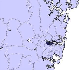
The City of Canada Bay is a local government area in the Inner West of Sydney, New South Wales, Australia. The city was formed on 1 December 2000, following the merger of Concord and Drummoyne councils. The city covers an area of 19.82 square kilometres (7.65 sq mi) and as at the 2016 census had a resident population of 88,015. The city is ultimately named after Canada Bay, a bay on the Parramatta River.

Abbotsford is a suburb in the Inner West of Sydney, in the state of New South Wales, Australia. Abbotsford is 10 kilometres west of the Sydney central business district in the local government area of the City of Canada Bay. Abbotsford sits on the peninsula between Abbotsford Bay and Hen and Chicken Bay, on the Parramatta River.

Five Dock is a suburb in the Inner West of Sydney, in the state of New South Wales, Australia. Five Dock is located 10 kilometres west of the Sydney central business district, in the local government area of the City of Canada Bay.

The Division of Lowe was an Australian Electoral Division in the state of New South Wales. It was located in the inner western suburbs of Sydney, on the south shore of the Parramatta River. It included the suburbs of Drummoyne, Five Dock, Croydon, Croydon Park, Burwood, Enfield, Homebush, Strathfield, Concord, Rhodes, Canada Bay, Cabarita, Abbotsford and Mortlake.

Woolwich is a suburb on the Lower North Shore of Sydney, in the state of New South Wales, Australia. Woolwich is located 11 kilometres north-west of the Sydney central business district, in the local government area of the Municipality of Hunter's Hill. Woolwich sits on the peninsula between the Lane Cove River and the Parramatta River, jutting out from Hunters Hill.
Russell Lea is a small suburb in the inner-west of Sydney, in the state of New South Wales, Australia. Russell Lea is located 8 kilometres west of the Sydney central business district in the local government area of the City of Canada Bay.

Putney is a suburb of Northern Sydney, New South Wales, Australia. It is located 14 kilometres (9 mi) north-west of the Sydney central business district on the northern bank of the Parramatta River. Its local government area is the City of Ryde.
Mortlake is a suburb in the Inner West of Sydney, in the state of New South Wales, Australia. It is 10 kilometres west of the Sydney central business district, in the local government area of the City of Canada Bay.

Drummoyne is a suburb in the Inner West of Sydney, in the state of New South Wales, Australia. Drummoyne is six kilometres west of the Sydney central business district and is the administrative centre for the local government area of the City of Canada Bay.

Hen and Chicken Bay is a bay on the Parramatta River, in the inner-west of Sydney, in the state of New South Wales, Australia. It lies approximately 8 kilometres due west of Sydney's central business district. It is surrounded by the suburbs of Abbotsford, Drummoyne, Wareemba, Five Dock, Canada Bay, Concord and Cabarita.

Breakfast Point is a suburb in the West of Sydney, in the state of New South Wales, Australia. Breakfast Point is located 16 kilometres west of the Sydney central business district. It is in the local government area of the City of Canada Bay. People from Breakfast Point are colloquially called Breakfastpointers.

Cabarita is a bayside suburb in the Inner West of Sydney, in the state of New South Wales, Australia. Cabarita is located 16 kilometres west of the Sydney central business district, in the local government area of the City of Canada Bay.

Henley is a suburb on the Lower North Shore of Sydney, in the state of New South Wales, Australia. Henley is located 9 kilometres west of the Sydney central business district, in the local government area of the Municipality of Hunter's Hill. Henley sits on the northern side of the Parramatta River.

Parramatta River ferry services connect suburbs along the Parramatta River in Sydney with Circular Quay by commuter ferry. The services are numbered F3 and form part of the Sydney Ferries network.

Cabarita ferry wharf is located on the southern side of the Parramatta River serving the Sydney suburb of Cabarita. It served by Sydney Ferries Parramatta River services operating between Circular Quay and Parramatta. The single wharf is served by RiverCat class ferries. The wharf was opened on 20 January 2000 in conjunction with improved transport services to Homebush Bay for the Sydney 2000 Olympic Games.

Bayview Park ferry wharf is a commuter wharf located in the Sydney suburb of Concord, New South Wales, on Hen and Chicken Bay. It is situated adjacent the namesake Bayview Park reserve, and upon the site of the historical Burwood ferry wharf, where Canadian exiles from the 19th century Lower Canada Rebellion landed in Sydney. Bayview Park was originally serviced by a Matilda Cruises route, before being included on Sydney Ferries' Parramatta River service in 2006, after a brief one-year service by Palm Beach Ferries. Services to the wharf were decommissioned by Sydney Ferries in October 2013, alongside Balmain West after patronage declined to a weekly average of 28 passengers. No operators currently service the wharf, although the structure still remains, with plans to return private ferry services to the wharf as part of a redevelopment project for a factory in eastern Concord.

Wentworth Point is a suburb of Sydney, in the state of New South Wales, Australia. It is located 13 kilometres west of the Sydney central business district, on the eastern edge of the local government area of City of Parramatta. It is on the western shore of Homebush Bay on the southern side of the Parramatta River. Wentworth Point is usually regarded as part of the Greater Western Sydney region, including in administrative contexts, but it is also regarded as part of the Inner West region of Sydney in some contexts, especially commercial contexts.


