Five Dock, New South Wales

Last updated

Five Dock
Sydney,  New South Wales
Five Dock Great North Road NationalBank.jpg
Old bank building on Great North Road, Five Dock
Five Dock, New South Wales
Map
Location map Australia Sydney.png
Red pog.svg
Five Dock
Coordinates 33°51′54″S151°07′43″E / 33.86512°S 151.12856°E / -33.86512; 151.12856
Population9,356 (2016 census) [1]
 • Density3,819/km2 (9,891/sq mi)
Established1794[ citation needed ]
Postcode(s) 2046
Elevation22 m (72 ft)
Area2.45 km2 (0.9 sq mi)
Location10 km (6 mi) west of Sydney CBD
LGA(s) City of Canada Bay
State electorate(s) Drummoyne
Federal division(s) Reid
Suburbs around Five Dock:
Concord Wareemba Russell Lea
Canada Bay Five Dock Rodd Point
Croydon Ashfield Haberfield

Five Dock is a suburb in the Inner West [2] of Sydney, in the state of New South Wales, Australia. Five Dock is located 10 kilometres west of the Sydney central business district, in the local government area of the City of Canada Bay.

Contents

Location

NASA image of Sydney Five Dock's borders in red. NASA satellite image PIA03498 of Sydney, cropped, and modified to show Five Dockl borders.jpg
NASA image of Sydney Five Dock's borders in red.

Five Dock lies roughly at the foot, or southern end, of the Drummoyne peninsula. More precisely, Five Dock lies between Parramatta Road and the City West Link to the south and Hen & Chicken Bay, on the Parramatta River, along with the suburbs of Wareemba and Russell Lea, to the north. Its total area is 2.45 km2 (0.95 sq mi). [3]

Rodd Point lies to the east. Haberfield adjoins Five Dock to the south-east. Iron Cove forms a small section of the suburb's eastern boundary. Ashfield and Croydon lie on the other side of Parramatta Road, to the south. The suburbs of Canada Bay and Concord adjoin Five Dock's western boundary. Burwood lies just beyond Croydon, to the south-west.

From the heart of the shopping centre, it is approximately 7.5 kilometres (4.7 mi) to the Sydney central business district, measured in a straight line from the General Post Office in Martin Place. By road, this same distance is about 9–10 kilometres (5.6–6.2 mi), depending on the route taken. [4]

History

Portrait (signed "W.W.") thought to depict Bennelong Bennelong.jpg
Portrait (signed "W.W.") thought to depict Bennelong
John Hunter, explorer and Governor of New South Wales John Hunter - Project Gutenberg eText 12992.jpg
John Hunter, explorer and Governor of New South Wales

Origin of the name

The earliest written reference to Five Dock is in The Sydney Gazette of 3 February 1805, which mentions Five Dock Bay.[ citation needed ] All of the sources referenced are in agreement that it was derived from the shape of the bay along the Parramatta River.

According to a publication from the Maritime Services Board, Port of Sydney, (Volume 9, No 3, September 1965), "At the NE point of the bay there were five water worn indentations that were likened to docks, hence the name Five Dock." [5] There is widely contradictory information, however, about how many of these natural formations still exist. The Maritime Services Board publication concludes that there "are two of the five remaining". However, Eric Russell's Drummoyne: a western suburbs' history from 1794 states that one was lost with the construction of the 1881 Gladesville Bridge, but "the others remain in 1982". Other sources give different numbers again.

The former Five Dock Post Office, Great North Road Old Post Office, Henry Street, Five Dock, Australia.jpg
The former Five Dock Post Office, Great North Road
Bushells factory in Concord over Kings Bay and Canada Bay from Friend Avenue, Five Dock FiveDockFriendAvenue.jpg
Bushells factory in Concord over Kings Bay and Canada Bay from Friend Avenue, Five Dock

Local names

Many Five Dock streets are named after mayors, aldermen and other associated with local government, including Charles Street, Corden Avenue, Henley Marine Drive, Hill Street, Howley Street, Ingham Avenue, Kerin Avenue, McGrath Avenue, McKinnon Avenue, Myler Street, Preston Avenue, Sutton Street, Timbrell Drive, Udall Avenue, West Street and William Street.

Another series of streets is named after early landowners, subdividers and prominent local businessmen, including Ramsay Road, Taylor Street, Mitchell Street, Betts Avenue, Friend Avenue, Harris Road, Gildea Avenue and Bennett Avenue. Rickard Street, Noble Street, Heath Street and Augusta Street were named after Sir Arthur Rickard and members of his family. Rodd Road, Trevanion Street and Barnstaple Road are named after Brent Clements Rodd and members of his family. A few streets take their name from local residents, including Mackaness Close and Langsworth Way.

The Great White Fleet visited Sydney in August 1908 and several local street names recall ships in the fleet. Connecticut Avenue is named after USS Connecticut. Illinois Street is named after USS Illinois. Minnesota Avenue takes its name from USS Minnesota. New Jersey Road takes its name from USS New Jersey.

A few streets are named after prominent people: Queens Road after Queen Victoria; Garfield Avenue after American President James Garfield, Kingsford Avenue after Charles Kingsford Smith, Bevin Avenue after Ernest Bevin and Henry Lawson Avenue after Henry Lawson, who lived on Great North Road briefly in 1922.[ citation needed ] The name of Coronation Avenue commemorates the coronation of King George VI and Queen Elizabeth.

Churches

St Alban's Anglican Church, Great North Road FiveDockStAlbansChurch.jpg
St Alban's Anglican Church, Great North Road

St Alban's Anglican Church [6] is a 1924 Gothic church, constructed of brick and stone. It is well-built church, using locally quarried stone, and remains very well preserved. It is a heritage item and is listed in the Department of the Environment and Heritage's Australian Heritage database. [7] Significant or attractive features of the church include its interior carpentry, the pipe organ (which dates from 1891 and was built by W. Davidson) and its stained glass. St Alban's rectory is on the same large site as the church, and together they form an important group. The foundations of the rectory, like those of the church, are constructed of local stone. In 2008 the church was part of an amalgamation with the Parishes of Ashfield and Haberfield, forming Christ Church Inner West Anglican Community. [8]

Schools

All Hallows' Parish School, Domremy College, Five Dock Public School, Lucas Gardens School, Rosebank College.

The foundation stone of Five Dock Public School was laid in the grounds of St Albans church in 1858, [9] and it opened in 1861.

Domremy College Five Dock

Named after Joan of Arc's birthplace, Domremy, Domremy College is a Catholic Secondary School for girls. It is located on First Avenue, opposite Five Dock Park. The school was founded in 1911, initially having just 12 students. The school originally taught students from infants through to the end of senior school. This was later scaled back to just years 7 to 10. However, since 1985, the school has taught girls from year 7 through to year 12. The Domremy Convent group is listed on the NSW Heritage Office State Heritage Register. [10]

Houses

Typical Five Dock bungalow house Five Dock house, NSW, Australia.jpg
Typical Five Dock bungalow house

Housing in Five Dock consists mainly of detached dwellings. Like many suburbs in the inner-west of Sydney, Five Dock has some well-preserved examples of Australian Federation architecture and California Bungalow style residences. [ citation needed ] Many of these homes have been renovated however, and have not retained all of their original features.

Many dwellings in Five Dock are detached houses, frequently with generously sized gardens. According to the 2011 census, of the 3,760 dwellings in the suburb, 1,676 consist of separate houses, 472 were other types of houses and 1,228 were flats or apartments. [1] Despite the preponderance of houses, Post-World War II development has involved a high proportion of apartment construction. Recently[ when? ], several major residential developments have been completed. An example is the 'Pendium' development in Garfield Street, which includes 102 apartments, a refurbished supermarket and the local library. Another recent example is the redevelopment of the former EnergyAustralia site in Fairlight Street into 93 units .

As of October 2005, there are a total of 51 items in the suburb that are heritage listed by the NSW Heritage Office. In addition, the skateboard track in Five Dock Park is being considered for listing as a heritage item under the State Heritage Items Project. [11]

Houses along the Bay run in Five Dock Five dock-ironcove.jpg
Houses along the Bay run in Five Dock

Commercial area

The Five Dock retail and commercial centre is made up of a long line of shops, banks, restaurants and other services which run for about 500 metres (1,600 ft) along Great North Road in a section between Lyons Road and Queens Road. It features a high proportion of small local businesses. There are a number of shops selling Italian foods which reflects the number of residents of Italian background. The Five Dock telephone exchange is located at 190-192 Great North Road. Previously home to independent supermarket retailer, Supabarn, Coles [12] purchased key locations [13] from Supabarn and is now the primary supermarket in Five Dock.

Parks

Five Dock has two separate stretches of publicly accessible foreshore on the Parramatta River. One of these foreshore stretches constitutes a small section of the Bay Run, a popular 7 km walking and cycling track which passes through several other suburbs along its way around Iron Cove. The other foreshore area lies on Hen & Chicken Bay and Kings Bay, and features a pedestrian and bike path leading around the bay towards Abbotsford.

In addition, there are several public parks located around Five Dock, the three largest being Timbrell Park, Five Dock Park and Halliday Park. A large section of Barnwell Park Golf Course, which is owned by Canada Bay Council, is located in Five Dock. A nine-hole golf course was constructed in 1963-4, and a second nine holes was completed in 1974 with much of the course lying on reclaimed land. [14]

Timbrell Park

Timbrell Park comprises a number of multi-use sports fields and an amenities block. This field is the home ground of the Five Dock Falcons [15] baseball team. Also located at Timbrell Park is an all abilities playground, Livvi's Place - an initiative of the City of Canada Bay, Touched by Olivia Foundation and Leighton Contractors. Livvi's Place was developed to reduce the barriers experienced by those with special needs, and allow children of all abilities to play together, side by side. In 2010, Livvi's Place in Five Dock was named as the best play space in the country by Parks and Leisure Australia. [16] Located outside Livvi's Place is Livvi's Cafe which opened in 2014.

Five Dock Park and Oval

Five Dock Park was the first park in the borough with 28 acres of land being purchased from the government in 1883 for 5000 pounds. [17] It is listed on the NSW Heritage Office State Heritage Register and centres around The Five Dock War Memorial. The plaque at the memorial says that the foundation stone was laid in 1923.[ citation needed ] The memorial was renovated and rededicated in 1987. The park also contains a number of recreational facilities, including a large skate boarding area, a bowling club, tennis courts, an oval (used for junior rugby league matches and cricket), childcare facilities and an off-leash area for dogs. Originally constructed in 1979, the park's skate boarding and bmx area was extremely popular during the 1980s but gradually fell into disrepair. An article published in the Village Voice in 2002 said the National Skateboarders' Association had nominated Five Dock skate park as one of the three worst in NSW because it was in such a poor condition, with a subsequent article discussing calls for its upgrade. The new skatepark opened in 2007 was built next to the 'old bowl' and was designed by Mick Mulhall..

Transport

The major roads that run through or adjoin Five Dock include Great North Road, Parramatta Road, Lyons Road, Queens Road, and Ramsay Road.

Five Dock is approximately a 40-minute commute to the CBD via public transport, on either routes 437, 438X or 502.

Five Dock is connected to the city and surrounding suburbs by Transit Systems-operated bus routes. As of 2020, bus routes that run through or begin/terminate include:

Proposed Metro Station

Five Dock is a future rapid transit station that will be built as part of the Sydney Metro West project, connecting Westmead to the CBD. [18] [19]

A man in costume at Ferragosto FiveDockFerrogostoMan.jpg
A man in costume at Ferragosto

Demographics

Five Dock is an established suburb with a population of 9,356 in the 2016 census. The most common reported ancestries in Five Dock were Italian 18.9%, Australian 16.1%, English 15.8%, Irish 7.7% and Chinese 5.8%. 61.9% of people were born in Australia. The next most common countries of birth were Italy 8.2%, England 2.9%, China 2.8% and New Zealand 2.0%. 61.3% of people only spoke English at home. Other languages spoken at home included Italian 13.4%, Mandarin 3.2%, Cantonese 2.4%, Greek 2.1% and Spanish 1.6%. The most common responses for religion were Catholic 43.2% and No Religion 23.3%. [1]

Like the nearby suburbs of Haberfield and Leichhardt, Five Dock has a large population of Italian immigrants. This Italian influence is reflected in several ways, for instance in the style of the suburb's restaurants, cafes and delis. Five Dock Public School has had an Italian language teaching program since 1981 and there are local private language schools offering Italian classes. In addition, Five Dock has an annual street festival called Ferragosto, based on the traditional Italian festival of the same name. [20]

Notable residents

Politics

In the federal parliament, Five Dock is in the Division of Reid, an electoral division which includes the surrounding suburbs of Drummoyne, Concord, Rhodes, Burwood and Strathfield. A Labor seat since its inception in 1922, it elected a Liberal member for the first time in the 2013 federal election, for which it held until the 2022 federal election. Since 2022, the current member for Reid is Sally Sitou of the Australian Labor Party.

In the state parliament, Five Dock is in the Electoral district of Drummoyne, which is similar to the federal division but excludes the areas of Homebush, Burwood and Strathfield. This makes it nominally a Liberal seat, despite suffering a 12% swing in the 2023 state election. Its current member since 2023 is Stephanie Di Pasqua, who is also the deputy mayor of the City of Canaday Bay Council.

Related Research Articles

<span class="mw-page-title-main">Ryde, New South Wales</span> Suburb of Sydney, New South Wales, Australia

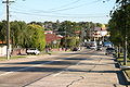
Ryde is a suburb of Sydney, New South Wales, Australia. Ryde is located 13 km north-west of the Sydney central business district and 8 km east of Parramatta. Ryde is the administrative centre of the local government area of the City of Ryde and part of the Northern Sydney region. It lies on the north bank of the Parramatta River. People from Ryde are colloquially known as Ryders, Rydiens or Rydemen.

<span class="mw-page-title-main">Municipality of Strathfield</span> Local government area in New South Wales, Australia

The Municipality of Strathfield is a local government area in the West of Sydney, in the state of New South Wales, Australia.

<span class="mw-page-title-main">Inner West</span> Region in New South Wales, Australia

The Inner West of Sydney is an area directly west of the Sydney central business district, New South Wales, Australia. The suburbs that make up the Inner West are predominantly located along the southern shore of Port Jackson, stretching south to the shores of the Cooks River. The western boundary of the Inner West is approximately the A3 arterial road, which divides the Inner West from the Greater Western Sydney region. The Inner West is much larger than the Inner West Council local government area. The Inner West roughly corresponds with the Parish of Petersham and Parish of Concord, two cadastral divisions used for land titles.

<span class="mw-page-title-main">Hunters Hill, New South Wales</span> Suburb of Sydney, New South Wales, Australia

Hunters Hill is a suburb of the lower north shore of Sydney, in the state of New South Wales, Australia. Hunters Hill is located 9 kilometres (5.6 mi) north-west of the Sydney central business district and is the administrative centre for the local government area of the Municipality of Hunter's Hill.

<span class="mw-page-title-main">Ashfield, New South Wales</span> Suburb of Sydney, New South Wales, Australia

Ashfield is a suburb in the Inner West of Sydney, in the state of New South Wales, Australia. Ashfield is about 8 kilometres west of the Sydney central business district.

<span class="mw-page-title-main">Haberfield, New South Wales</span> Suburb of Sydney, New South Wales, Australia

Haberfield is a suburb in the Inner West of Sydney, in the state of New South Wales, Australia. Haberfield is located 6.5 kilometres west of the Sydney central business district in the local government area of the Inner West Council.

<span class="mw-page-title-main">Croydon, New South Wales</span> Suburb of Sydney, New South Wales, Australia

Croydon is a suburb in the Inner West of Sydney, in the state of New South Wales, Australia. It is located 9 kilometres (5.6 mi) west of the Sydney central business district. Croydon is split between the two local government areas of Municipality of Burwood and the Inner West Council.

<span class="mw-page-title-main">Burwood, New South Wales</span> Suburb of Sydney, New South Wales, Australia

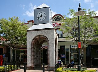
Burwood is a suburb in the Inner West of Sydney, in the state of New South Wales, Australia. It is 10 kilometres (6.2 mi) west of the Sydney central business district and is the administrative centre for the local government area of Municipality of Burwood. People from Burwood are colloquially known as Burwoodiens or Burwooders.

<span class="mw-page-title-main">Canada Bay, New South Wales</span> Suburb of Sydney, Australia

Canada Bay is a suburb in the Inner West of Sydney, in the state of New South Wales, Australia. It is 11 kilometres (6.8 mi) west of the Sydney central business district, in the local government area of City of Canada Bay.

<span class="mw-page-title-main">City of Canada Bay</span> Local government area in New South Wales, Australia

The City of Canada Bay is a local government area in the Inner West of Sydney, New South Wales, Australia. The city was formed on 1 December 2000, following the merger of Concord and Drummoyne councils. The city covers an area of 19.82 square kilometres (7.65 sq mi) and as at the 2021 census had a resident population of 89,177. The city is ultimately named after Canada Bay, a bay and suburb along the Parramatta River.

<span class="mw-page-title-main">North Strathfield, New South Wales</span> Suburb of Sydney, New South Wales, Australia

North Strathfield is a suburb in the inner-west of Sydney, in the state of New South Wales, Australia. North Strathfield is located 15 kilometres west of the Sydney central business district, in the local government area of the City of Canada Bay. Strathfield and Strathfield South are separate suburbs, to the south.

<span class="mw-page-title-main">Wareemba, New South Wales</span> Suburb of Sydney, New South Wales, Australia

Wareemba is a suburb in the Inner West of Sydney in the state of New South Wales, Australia. Wareemba is 12 kilometres west of the Sydney central business district in the local government area of the City of Canada Bay. Wareemba sits on the eastern shore of Hen and Chicken Bay, on the Parramatta River. It is almost the smallest suburb in Sydney by land area.

<span class="mw-page-title-main">Concord, New South Wales</span> Suburb of Sydney, New South Wales, Australia

Concord is a suburb in the inner West of Sydney, in the state of New South Wales, Australia. It is 10 kilometres (6.2 mi) west of the Sydney central business district, in the local government area of the City of Canada Bay. Concord West is a separate suburb, to the north-west.

<span class="mw-page-title-main">Drummoyne, New South Wales</span> Suburb of Sydney, New South Wales, Australia

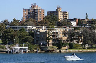
Drummoyne is a suburb in the Inner West of Sydney, in the state of New South Wales, Australia. Drummoyne is six kilometres west of the Sydney central business district and is the administrative centre for the local government area of the City of Canada Bay.

<span class="mw-page-title-main">Croydon Park, New South Wales</span> Suburb of Sydney, New South Wales, Australia

Croydon Park is a suburb in the Inner West of Sydney, in the state of New South Wales, Australia. Croydon Park is 10 kilometres south-west of the Sydney central business district and is divided between the local government areas of the City of Canterbury-Bankstown, Municipality of Burwood and Inner West Council. Croydon is a separate suburb, to the north.

<span class="mw-page-title-main">Chiswick, New South Wales</span> Suburb of Sydney, New South Wales, Australia

Chiswick is a suburb in the Inner West of Sydney, in the state of New South Wales, Australia. It is located 9 kilometres west of the Sydney central business district in the local government area of the City of Canada Bay. Chiswick sits on the peninsula between Abbotsford Bay and Five Dock Bay, on the Parramatta River. It is surrounded by the suburbs of Abbotsford, Russell Lea and Drummoyne.

<span class="mw-page-title-main">Parramatta River ferry services</span>

Parramatta River ferry services connect suburbs along the Parramatta River in Sydney with Circular Quay by commuter ferry. The services are numbered F3 and form part of the Sydney Ferries network.

<span class="mw-page-title-main">Iron Cove Creek</span> River in New South Wales, Australia

Iron Cove Creek, a southern tributary of the Parramatta River, is an urban stream west of Sydney Harbour, located in the inner-western Sydney suburbs of Croydon, Ashfield, Haberfield and Five Dock in New South Wales, Australia.

<span class="mw-page-title-main">Wentworth Point, New South Wales</span> Suburb of Sydney, New South Wales, Australia

Wentworth Point is a suburb of Sydney, in the state of New South Wales, Australia. It is located 13 kilometres west of the Sydney central business district, on the eastern edge of the local government area of City of Parramatta. It is on the western shore of Homebush Bay on the southern side of the Parramatta River. Wentworth Point is usually regarded as part of the Greater Western Sydney region, including in administrative contexts, but it is also regarded as part of the Inner West region of Sydney in some contexts, especially commercial contexts.

<span class="mw-page-title-main">The Priory, Burwood</span> Heritage-listed residence in Sydney

The Priory is a heritage-listed residence at 213 Burwood Road, in the Sydney suburb of Burwood in the Municipality of Burwood local government area of New South Wales, Australia. It was built in 1877. The Priory and its grounds was added to the New South Wales State Heritage Register on 2 April 1999.

References

  1. 1 2 3 Australian Bureau of Statistics (27 June 2017). "Five Dock (State Suburb)". 2016 Census QuickStats. Retrieved 14 August 2017. OOjs UI icon edit-ltr-progressive.svg
  2. Australian Suburb Guide: Sydney Inner West Archived 26 December 2012 at the Wayback Machine Retrieved 8 August 2013.
  3. City of Canada Bay Council | Home
  4. Approximate measurements made using Sydney and Blue Mountains 2004 Street Directory, UBD, 40th Edition, ISBN   0-7319-1465-1 and Bikely.
  5. "Five Dock". Geographical Names Register (GNR) of NSW. Geographical Names Board of New South Wales. OOjs UI icon edit-ltr-progressive.svg
  6. "Home". stalbanschurch.com.au.
  7. "Place ID 102001". Australian Heritage Database . Australian Government.
  8. Smith, Joseph (28 December 2007). "New Year = New Parish". Southern Cross. The Anglican Diocese of Sydney. ISSN   1445-0089.
  9. "RELIGIOUS MEMORANDA". Sydney Morning Herald . NSW. 9 October 1858. p. 5. Retrieved 26 May 2011.
  10. Heritage Branch Website - Online Database
  11. "NSW Heritage Office Website - About the Heritage Office". www.heritage.nsw.gov.au. Archived from the original on 25 October 2004.
  12. "Coles Supermarkets". www.coles.com.au. Retrieved 18 July 2018.
  13. Hannaford, Scott (19 June 2015). "Coles buys independent Supabarn supermarkets in Canberra and NSW". Sydney Morning Herald. Retrieved 18 July 2018.
  14. "The History of Barnwell Park Golf Club" (PDF). July 2008. p. 5.
  15. "Five Dock Falcons Baseball Club – Seniors and Juniors". www.fivedockfalcons.com.au. Retrieved 18 July 2018.
  16. "Timbrell Park Playground Livvi's Place Five Dock City of Canada Bay Livvis Place - City of Canada Bay Council". www.canadabay.nsw.gov.au. Retrieved 18 July 2018.
  17. "Sydney Morning Herald". 7 February 1888.
  18. Sydney Metro West stations confirmed Sydney Metro 21 October 2019
  19. Sydney Metro West Project Overview Booklet Sydney Metro 21 October 2019
  20. "Ferragosto 2013". City of Canada Bay. Retrieved 4 May 2013.
  21. "Fenech to undergo surgery after stabbing". 5 January 2004.
  22. "Peter Dodds McCormick" . Retrieved 4 May 2013.

Further reading