Waverley Council takes its name from the suburb but its administrative centre is located in the adjacent suburb of Bondi Junction, which is also a major commercial centre. Waverley is the highest point of altitude in Sydney's Eastern Suburbs.
History
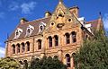
Edina, War Memorial Hospital.
Waverley takes its name from a home built near Old South Head Road in 1827 by Barnett Levey (or Levy) (1798–1837). It was named Waverley House, after the title of his favourite book, Waverley, by author Sir Walter Scott. Waverley Municipality was proclaimed in June 1859. The house was a distinctive landmark and gave its name to the surrounding suburb.[3]
Waverley Cemetery (South Head General Cemetery) was established in 1877 and is one of Australia's most notable cemeteries due to its cliff-side location. The cemetery features the graves of several notable Australians including poet Henry Kendall and aviator Lawrence Hargrave.[4]
Edina, a late Victorian mansion built on a grand scale in Birrell Street by Ebenezer Vickery for himself and his family, was completed around 1884.[citation needed] Vickery was a leading merchant and a prominent patron of the Methodist Church. Other buildings in the group include Banksia, Witchagil and the Nellie Vickery Memorial Chapel. Banksia and Witchagil are two-storey villas that Vickery built for his sons.[citation needed]
This distinguished group of Victorian buildings is now used as the War Memorial Hospital. Edina, Banksia and Witchagil are on the (now defunct) Register of the National Estate.[5] Other heritage items in Waverley include the two weatherboard cottages in Judges Lane, off Bronte Road. A building in Waverley once collapsed into a large hole that swallowed ten houses and an entire street.
Heritage listings
Waverley has a number of heritage-listed sites, including:
45 Victoria Street: Mary Immaculate Catholic Church, Waverley,[7] designed by John Hennessy in 1912. Its twin-towered design is said to be reminiscent of the Italian Renaissance and is an example of the Federation Academic Classical style.[8]
Victoria Street, Presbyterian Church (Jubilee Church currently) was designed by Sydney architects Messrs Nixon and Allen. The foundation stone was laid by Mrs. Grahame on 8 May 1897.[citation needed]
Victoria Street, the Catholic Friary was demolished in 1985 after sustaining extensive fire damage (see gallery below).[citation needed]
Population
In the 2021 Census, there were 4,216 people in Waverley. 58.1% of people were born in Australia. The most common countries of birth were England 8.9% and New Zealand 2.9%. 75.3% of people only spoke English at home. The most common responses for religion were No Religion 40.3% and Catholic 25.0%.[1]
Commercial area
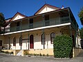
Robin Hood Hotel, an Art Deco style structure
Waverley is mostly residential with a scattering of commercial developments, centred on the road junction known as Charing Cross.
Schools
Waverley is home to a number of schools including Waverley Public School (state primary), the suburb includes:
Waverley College is a Christian Brothers school for boys made up of Our Lady's Mount Campus in Birrell Street, (Senior School Years 7-12), Waterford Campus in Henrietta Street (Junior School Years 5–6) and Waterford Pre School.[9]
St Charles' Primary School, Waverley. A Catholic primary school next door to St Clare's.
Sport and recreation
Waverley Oval
Waverley is represented in one of the most popular sporting competitions across Australia, the National Rugby League competition, by the local team the Sydney Roosters, officially the Eastern Suburbs District Rugby League Football Club (ESDRLFC).
The following clubs are located in or represent the Waverley area:
* Waverley Old Boys Football Club - Football (Soccer)
Waverley Amateur Radio Society - The oldest continuously licensed amateur radio club in Australia. The society was founded in Waverley in 1919 and is now located in nearby Rose Bay
Notable people
Current and former notable residents include:
Barney Wilson, a cinematographer and creative director working within the Australian film industry.
Millicent Armstrong (1888–1973), born in Waverley, was a playwright and farmer who wrote primarily about the experiences of country life in early 20th century Australia.
Queen Mary of Denmark (née Mary Donaldson) (born 1972), a resident of Porter Street near Bronte Road, and formerly involved in Eastern Suburbs real estate before her marriage to then Crown Prince Frederik.
Reg Lindsay (1929–2008), country music star. Lindsay was born in Waverley.
Pakie Macdougall was born here in 1875. She was a leading figure of the art scene in Sydney in the 1930s[12]
↑ Kirkpatrick, Peter, "Augusta (Pakie) Macdougall (1875–1945)", Australian Dictionary of Biography, Canberra: National Centre of Biography, Australian National University, retrieved 24 January 2024
↑ Carey, Hilary M., "Reid, Elizabeth Julia (1915–1974)", Australian Dictionary of Biography, Canberra: National Centre of Biography, Australian National University, retrieved 5 March 2021
This page is based on this Wikipedia article Text is available under the CC BY-SA 4.0 license; additional terms may apply. Images, videos and audio are available under their respective licenses.