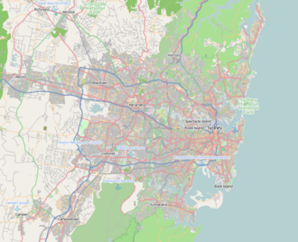
Old South Head Road

Last updated

Old South Head Road

Macquarie Lighthouse, Dunbar Head.jpg
Macquarie Lighthouse, Australia's first lighthouse, Vaucluse
Location map Australia Sydney.png
Red pog.svg
South end
Red pog.svg
North end
Coordinates
General information
TypeRoad
Length6.8 km (4.2 mi) [1]
Gazetted July 1933 [2]
Major junctions
South end Oxford Street
Bondi Junction, Sydney
 
North endRobertson Place
Watsons Bay, Sydney
Location(s)
Major suburbs Bondi Beach, Rose Bay, Vaucluse

Old South Head Road is a major road in Sydney, linking the eastern suburb of Bondi Junction to Watsons Bay on the South Head peninsula. It is historically significant because its earliest origins can be traced back to the early days of the colony of New South Wales.

Contents

Route

Old South Head Road commences at the intersection with Oxford Street, Syd Einfeld Drive and Bondi Road in Bondi Junction and heads in a north-easterly direction as a four-lane, single carriageway road, passing through the suburbs of Bondi, Bondi Beach, North Bondi and Rose Bay. It meets New South Head Road at a roundabout in Vaucluse, continuing north until it eventually terminates at a roundabout with Robertson Place in Watsons Bay.

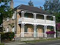
Old South Head Road passes through predominantly residential areas, with sizeable shopping centres around the intersections with Towns Road and Dover Road. Housing varies from detached homes to blocks of flats and units. The style of housing includes Federation homes, Victorian homes and Art Deco blocks of flats towards Bondi Junction.

History

The colony at Sydney began on 21 January 1788, when the First Fleet arrived in Sydney Harbour and Captain Arthur Phillip went ashore at what is now known as Camp Cove. The settlement itself was set up in Sydney Cove, at the spot now known as Circular Quay. One of the reasons for the choice of that location was the desire to be safely out of range of hostile artillery. The colony needed to keep watch on the seas for potentially hostile ships or the Second Fleet, which meant that South Head became important as an observation post. The outer edge of South Head became a signal station from which ships could be seen; their approach could then be signalled with flags. The ships could then be met by pilots who were camped at Camp Cove (so named for that reason). [3]

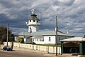
A proper signal station was established in 1790; it was supplied by boat until a bridle trail was created along the ridge to South Head. Construction of a road followed and it was completed in 1811. A lighthouse was built just south of the signal station in 1816–18, to a design by Francis Greenway, the first notable architect in the colony. A semaphore system replaced flags at the signal station in the 1840s and the present building was constructed to a design by Colonial Architect Mortimer Lewis. It has been in continuous use since then and is now heritage-listed. [4] In 1858, the first telegraph line in New South Wales was used to connect the signal station with the Royal Exchange in Bridge Street.

The passing of the Main Roads Act of 1924 [5] through the Parliament of New South Wales provided for the declaration of Main Roads, roads partially funded by the State government through the Main Roads Board (MRB). With the subsequent passing of the Main Roads (Amendment) Act of 1929 [6] to provide for additional declarations of State Highways and Trunk Roads, the Department of Main Roads (having succeeded the MRB in 1932) declared Main Road 339 from the intersection with Oxford Street in Bondi Junction to the intersection with Robertson Place in Watsons Bay on 18 July 1933. [2]

The passing of the Roads Act of 1993 [7] updated road classifications and the way they could be declared within New South Wales. Under this act, Old South Head Road retains its declaration as Main Road 339. [8]

Points of interest

(RNE) indicates that the structure or site is listed on the Register of the National Estate. [9]

Signal Hill Battery Signal hill battery vc.jpg
Signal Hill Battery

Major intersections

LGALocationkm [1] miDestinationsNotes
WoollahraWaverley boundary Bondi JunctionWoollahra boundary0.00.0 Oxford Street (southwest) – Bondi Junction, Paddington Southern terminus of road
Syd Einfeld Drive (west) – Woollahra, Paddington
Bondi Road (southeast)  Bondi
Bondi JunctionBellevue Hill boundary0.50.31Victoria Street – Double Bay
Bellevue HillRose BayBondi BeachNorth Bondi quadripoint1.60.99O'Sullivan Road (west)  Rose Bay
Curlewis Street (east) – Bondi Beach
Vaucluse 4.42.7Military Road – Dover Heights
5.13.2 New South Head RoadKings Cross, Double Bay, Rose Bay Roundabout
Woollahra Watsons Bay 6.84.2Robertson Place – Watsons Bay Northern terminus of road at roundabout
  •        Route transition

See also

Australia road sign W5-29.svg Australian Roadsportal

References

  1. 1 2 "Old South Head Road" (Map). Google Maps . Retrieved 22 June 2023.
  2. 1 2 "Main Roads Act, 1924-1931". Government Gazette of the State of New South Wales . No. 119. National Library of Australia. 4 August 1933. p. 2883. Archived from the original on 22 June 2023. Retrieved 22 June 2023.
  3. Walks in the Sydney Harbour National Park, Neil Paton (Kangaroo Press) 1987, p.58
  4. The Heritage of Australia, Macmillan Publishers, 1982, p.2/137
  5. State of New South Wales, An Act to provide for the better construction, maintenance, and financing of main roads; to provide for developmental roads; to constitute a Main Roads Board Archived 11 August 2022 at the Wayback Machine 10 November 1924
  6. State of New South Wales, An Act to amend the Main Roads Act, 1924-1927; to confer certain further powers upon the Main Roads Board; to amend the Local Government Act, 1919, and certain other Acts; to validate certain payments and other matters; and for purposes connected therewith. Archived 12 August 2022 at the Wayback Machine 8 April 1929
  7. State of New South Wales, An Act to make provision with respect to the roads of New South Wales; to repeal the State Roads Act 1986, the Crown and Other Roads Act 1990 and certain other enactments; and for other purposes. Archived 11 August 2022 at the Wayback Machine 10 November 1924
  8. Transport for NSW (August 2022). "Schedule of Classified Roads and Unclassified Regional Roads" (PDF). Government of New South Wales. Archived from the original (PDF) on 25 August 2022. Retrieved 1 August 2022.
  9. The Heritage of Australia, Macmillan Publishers, 1981, pp. 2/136-138

Commons-logo.svg Media related to Old South Head Road, Sydney at Wikimedia Commons