
The Garigal National Park is a protected national park that is located within the North Shore and Forest District regions of Sydney, New South Wales, in eastern Australia. The 2,202-hectare (5,440-acre) national park is situated approximately 20 kilometres (12 mi) north of the Sydney central business district.

The North Shore is a region of Sydney, New South Wales, Australia, a subset of the Northern Sydney region. The term is customary, not legal or administrative, and in customary usage generally includes the suburbs located on the northern side of Sydney Harbour up to Hornsby, and between Middle Harbour and the Lane Cove River.

The Northern Beaches is a region within Northern Sydney, in the state of New South Wales, Australia, near the Pacific coast. This area extends south to the entrance of Port Jackson, west to Middle Harbour and north to the entrance of Broken Bay. The area was formerly inhabited by the Garigal or Caregal people in a region known as Guringai country.

Pittwater Council was a local government area on the Northern Beaches of Sydney, in the state of New South Wales, Australia. It covered a region adjacent to the Tasman Sea about 30 kilometres (19 mi) north of the Sydney central business district. The area is named after Pittwater, the body of water adjacent to much of the area governed. First proclaimed in 1906 as the A Riding of Warringah Shire, the area was proclaimed as the Municipality of Pittwater on 1 May 1992. On 12 May 2016, the Minister for Local Government announced that Pittwater Council would be subsumed into the newly formed Northern Beaches Council. The last Mayor of Pittwater Council was Councillor Jacqui Townsend, an independent politician.

Warringah Council was a local government area in the northern beaches region of Sydney, in the state of New South Wales, Australia. It was proclaimed on 7 March 1906 as the Warringah Shire Council, and became "Warringah Council" in 1993. In 1992, Pittwater Council was formed when the former A Riding of Warringah Shire voted to secede. From this point on until amalgamation, Warringah Council administered 152 square kilometres (59 sq mi) of land, including nine beaches and 14 kilometres (9 mi) of coastline. Prior to its abolition it contained 6,000 hectares of natural bushland and open space, with Narrabeen Lagoon marking Warringah's northern boundary and Manly Lagoon marking the southern boundary.

Frenchs Forest is a suburb of northern Sydney, in the state of New South Wales, Australia. Frenchs Forest is 13 kilometres north of the Sydney central business district in the local government area of Northern Beaches Council. Frenchs Forest is part of Sydney's Northern Beaches region and also considered to be part of the Forest District, colloquially known as The Forest by its locals.

Wynyard railway station is a heritage-listed underground commuter rail station located in the north-west precinct of the Sydney central business district, in New South Wales, Australia. The station opened on 28 February 1932 to coincide with the opening of the Sydney Harbour Bridge.

The A3 is a major metropolitan arterial route in Sydney. It was formerly designated as Metroad 3. The A3 runs from its intersection with the A8 at Mona Vale at the north end, to the southerly of its two intersections with A1, the Princes Highway, at Blakehurst the south end. The highest speed limit on the (A3) is 90 km/h (56 mph) on Mona Vale Road.

Dee Why is a coastal suburb of northern Sydney, in the state of New South Wales, Australia, 18 kilometres north-east of the Sydney central business district. It is the administrative centre of the local government area of Northern Beaches Council and, along with Brookvale, is considered to be the main centre of the Northern Beaches region.
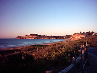
Mona Vale is a suburb of Sydney, in the state of New South Wales, Australia. It is located 28 kilometres north of the Sydney central business district, in an area known as the Northern Beaches. Formerly the administrative centre of Pittwater Council, it is now located in the local government area of Northern Beaches Council. The traditional custodians of the area are the Garigal people.

Pittwater is a semi-mature tide dominated drowned valley estuary, located about 40 kilometres (25 mi) north of the Sydney central business district, New South Wales, Australia; being one of the bodies of water that separate greater Metropolitan Sydney from the Central Coast.

Newport is a suburb in northern Sydney, placed on Sydney's Northern Beaches in the state of New South Wales, Australia, in the local government area of Northern Beaches Council. It is part of the Northern Beaches region.

Bayview is a suburb in Sydney's Northern Beaches region, in the state of New South Wales, Australia 31 kilometres north of the Sydney central business district, in the local government area of Northern Beaches Council.

The Sydney tramway network served the inner suburbs of Sydney, Australia from 1879 until 1961. In its heyday, it was the largest in Australia, the second largest in the Commonwealth of Nations, and one of the largest in the world. The network was heavily worked, with about 1,600 cars in service at any one time at its peak during the 1930s . Patronage peaked in 1945 at 405 million passenger journeys. Its maximum street trackage totalled 291 km in 1923.

The A8 is one of Sydney, Australia's metropolitan arterial routes, superseding Metroad 10. The A8 route runs for 23 kilometres from North Sydney to Mona Vale. The route includes parts of several different roads. The A8 designation replaced Metroad 10 during May 2013, much as the Metroad 10 route designation previously replaced the former State Route 14 designation in December 1998.

Northern Sydney is a large metropolitan area in Sydney, New South Wales, Australia on the north shore of Sydney Harbour and Parramatta River. The region embraces suburbs in Sydney’s north-east, north and inner north west. Northern Sydney is divided into distinctive regions such as the North Shore, Northern Beaches and Forest District.

B-Line is a bus route operated by Keolis Downer Northern Beaches between the central business district and the Northern Beaches in Sydney, Australia.

The Northern Beaches Council is a local government area located in the Northern Beaches region of Sydney, in the state of New South Wales, Australia. The council was formed on 12 May 2016 after the amalgamation of Manly, Pittwater and Warringah Councils.
