This article needs additional citations for verification .(September 2017) |
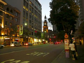
Stanley Street is a small street in the East Sydney locale, which is part of the suburb of Darlinghurst, Sydney, New South Wales.
This article needs additional citations for verification .(September 2017) |
Stanley Street is a small street in the East Sydney locale, which is part of the suburb of Darlinghurst, Sydney, New South Wales.
Stanley Street is primarily residential, but was the centre of Sydney's original Italian community in the 1950s and 1960s, and was subsequently part of Sydney's first "Little Italy". Many Italian restaurants and cafes still line the street, and the street is home to the annual Primo Italiano festival. [1]
The Bondi via Paddington tramway ran down Stanley Street until its closure and replacement by buses in 1960. [2]

A tram is a rail vehicle that travels on tramway tracks on public urban streets; some include segments on segregated right-of-way. The tramlines or networks operated as public transport are called tramways or simply trams/streetcars. Many recently built tramways use the contemporary term light rail. The vehicles are called streetcars or trolleys in North America and trams or tramcars elsewhere. The first two terms are often used interchangeably in the United States, with trolley being the preferred term in the eastern US and streetcar in the western US. Streetcar or tramway are preferred in Canada. In parts of the United States, internally powered buses made to resemble a streetcar are often referred to as "trolleys". To avoid further confusion with trolley buses, the American Public Transportation Association (APTA) refers to them as "trolley-replica buses". In the United States, the term tram has sometimes been used for rubber-tired trackless trains, which are unrelated to other kinds of trams.
Conservation and restoration of rail vehicles aims to preserve historic rail vehicles.

Circular Quay is a harbour, former working port and now international passenger shipping port, public piazza and tourism precinct, heritage area, and transport node located in Sydney, New South Wales, Australia on the northern edge of the Sydney central business district on Sydney Cove, between Bennelong Point and The Rocks. It is part of the local government area of the City of Sydney.

Brighton Le Sands, is a suburb in southern Sydney, in the state of New South Wales, Australia. Brighton Le Sands is located 13 kilometres south of the Sydney central business district, on the western shore of Botany Bay. Brighton Le Sands is in the local government area of the Bayside Council and is part of the St George area.

George Street is a street in the central business district of Sydney.

Broadway is a 700-metre (2,300 ft) road in inner city Sydney, New South Wales, Australia. The road constitutes the border between the suburbs of Ultimo and Chippendale. Broadway is also an urban locality.

King Street is the central thoroughfare of the suburb of Newtown in Sydney, Australia. The residents of the area, including a higher-than-average concentration of students, LGBT people and artists, are most visible on this street, sealing Newtown's reputation as Sydney's premier hub of subcultures. The street can be divided geographically into two sections, North and South. King Street is particularly notable for the many picturesque Victorian era and Edwardian era commercial buildings that line the street.

The Sydney tramway network served the inner suburbs of Sydney, Australia from 1879 until 1961. In its heyday, it was the largest in Australia, the second largest in the Commonwealth of Nations, and one of the largest in the world. The network was heavily worked, with about 1,600 cars in service at any one time at its peak during the 1930s . Patronage peaked in 1945 at 405 million passenger journeys. Its maximum street trackage totalled 291 km in 1923.

City Road is a busy 1-kilometre (0.62 mi) thoroughfare located in Sydney, New South Wales, Australia. City Road runs south from a junction with Broadway and Parramatta Road, through the University of Sydney and becomes King Street as it enters the suburb of Newtown.
Park Street is a street in the central business district of Sydney in New South Wales, Australia. It runs from George Street in the west to College Street in the east, where it becomes William Street.

College Street is a 700-metre (2,300 ft) major street in the central business district of Sydney in New South Wales, Australia. From north to south, it runs from east of Queens Square and St James station to start at the junction of the Prince Albert, St Marys, and Art Gallery roads and runs to Whitlam Square, at Liverpool Street. The street gets its name from a college on the street, St. Mary’s Cathedral College. The street runs beside the eastern border of Hyde Park, and is lined by the Australian Museum, Sydney Grammar School, Cook and Phillip Park Aquatic and Fitness Centre, St Mary's Cathedral, and Australian International College.

The Bayswater Road is a 600-metre-long (2,000 ft) minor street in the Kings Cross district of Sydney, New South Wales, Australia.
Cleveland Street is a busy thoroughfare located to the south of the central business district of Sydney in New South Wales, Australia. From west to east, it runs from City Road in Chippendale, through Darlington, across the railway lines between Central and Redfern stations and east through Surry Hills, crossing the Eastern Distributor and South Darling Street, to terminate at Anzac Parade, Moore Park. The street is named after Captain Cleveland, an officer of the 73rd regiment.

Georgia Street is an east–west street in the cities of Vancouver and Burnaby, British Columbia, Canada. Its section in Downtown Vancouver, designated West Georgia Street, serves as one of the primary streets for the financial and central business districts, and is the major transportation corridor connecting downtown Vancouver with the North Shore by way of the Lions Gate Bridge. The remainder of the street, known as East Georgia Street between Main Street and Boundary Road and simply Georgia Street within Burnaby, is more residential in character, and is discontinuous at several points.

King Street is a street in the Sydney central business district in New South Wales, Australia. It stretches from King Street Wharf and Lime Street near Darling Harbour in the west, to Queens Square at St James railway station in the east.

The earliest trams in Australia operated in the latter decades of the 19th century, hauled by horses or "steam tram motors". At the turn of the 20th century, propulsion almost universally turned to electrification, although cable trams lingered in Melbourne. In cities and towns that had trams, they were a major part of public transport assets.
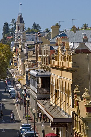
High Street is the main street running through the City of Fremantle, Western Australia. The street passes by historic landmarks, including the Round House, the Fremantle Town Hall, and the Fremantle War Memorial, through the Fremantle West End Heritage area and through two town squares. Trams operated along High Street for 47 years, between 1905 and 1952. Running east–west, High Street continues as Leach Highway, a major arterial road, at Stirling Highway, linking Fremantle with Perth Airport although the stretch of road between Stirling Highway and Carrington Street is known locally—and signed—as High Street.

The Altrincham Line is a tram line of the Manchester Metrolink running from Manchester to Altrincham in Greater Manchester. Originally a railway line, it was, along with the Bury Line, converted into a tramway during 1991–92, as part of the first phase of the Metrolink system.
The Y1-class was a class of four trams built by the Melbourne & Metropolitan Tramways Board built as a modified version of the Y-class to trial one man operation. Initially used on East and West Preston routes from Collins Street, from 1934 they were transferred to the Toorak line. From 1936 they were used on Burwood services from Camberwell depot. In 1933, 613 was used on Victorian Railways' Sandringham railway station to Black Rock line.

Rockhampton Council Tramways was a steam tram service which was operated by Rockhampton City Council from 1909 until 1939 in the city of Rockhampton, Queensland, Australia. Rockhampton was the only regional city in the state of Queensland to have had a tram service. The line has since been rebuilt and is operated as a tourist attraction by the Archer Park Rail Museum.
Route map: