Cleveland Street, Sydney

Last updated

Cleveland Street

Location map Australia Sydney.png
Red pog.svg
West end
Red pog.svg
East end
Coordinates
General information
TypeStreet
Length2.8 km (1.7 mi) [1]
Gazetted February 1933 [2]
Maintained by Transport for NSW
Former
route number
  • AUS Metroad 4.svg Metroad 4 (1992–2000)
  • Australian state route 11.svg State Route 11 (1974–1992)
  • Sydney Ring Road 1.svg Ring Road 1 (1964–1974)
  • (Chippendale–Surry Hills)
Major junctions
West endAUS Alphanumeric Route A36.svg City Road
Camperdown, Sydney
 
East endLang Road
Moore Park, Sydney
Location(s)
Major suburbs Chippendale, Darlington, Redfern, Surry Hills

Cleveland Street is a busy thoroughfare located to the south of the central business district of Sydney in New South Wales, Australia. The street is named after Captain Cleveland, an officer of the 73rd regiment.[ citation needed ]

Contents

Route

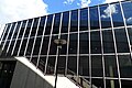
Cleveland Street commences at its intersection with City Road in Chippendale and heads in an easterly direction as a four-lane, single carriageway road through Darlington, over the railway lines between Central and Redfern stations and east through Surry Hills, crossing the Eastern Distributor and South Darling Street, to eventually terminate at the intersection with Anzac Parade and Lang Road, Moore Park.

History

Governor Macquarie granted a substantial parcel of land in the Surry Hills and Redfern area to Charles Smith in 1809, who established Cleveland Gardens, as either a market garden or nursery in the area. [3] [4] Daniel Cooper purchased approximately five hectares (twelve acres) from Smith and built the heritage-listed Cleveland House in the early 1820s. The decision in 1850 to build Redfern terminus brought industry to the area and resulted in the subdivision of many of the gentlemen's estates in the neighbouring suburb of Surry Hills. [5]

Prior to the 1840s, maps marked Cleveland Street, from Chippendale to Moore Park, as the unsurveyed 'Government Road'. [6]

The passing of the Main Roads Act of 1924 [7] through the Parliament of New South Wales provided for the declaration of Main Roads, roads partially funded by the State government through the Main Roads Board (later the Department of Main Roads, and eventually Transport for NSW). With the subsequent passing of the Main Roads (Amendment) Act of 1929 [8] to provide for additional declarations of State Highways and Trunk Roads, the Department of Main Roads (having succeeded the MRB in 1932) declared Main Road 330 from the intersection with City Road to the intersection with Dowling Street (today South Dowling Street) in Surry Hills on 21 February 1933, [2] and extended east to the intersection with Anzac Parade on 2 December 1964. [9]

The passing of the Roads Act of 1993 [10] updated road classifications and the way they could be declared within New South Wales. Under this act, Cleveland Street retains its declaration as Main Road 330. [11]

The route was part of Sydney's first Ring Roads, and was allocated Ring Road 1 between Abercrombie Street and South Dowling Street in 1964; this was replaced by State Route 11 in 1974, and then Metroad 4 in 1992. Metroad 4 was later re-aligned along City West Link on its completion in 2000; Cleveland Street has remained without an allocation since.

Education

In 1851, some land was reserved in the "Cleveland Paddocks" for a school to be established. [12] Located on the corner of Cleveland and Chalmers Streets, the Cleveland Street Public School was established in prefabricated iron buildings in 1856, as a model school. New sandstone Gothic buildings were constructed in 1867-68, which remain, along with later buildings on the site. The school became an intermediate school in 1913 and later a high school. [13] In 1977 the site was repurposed as an intensive English language tuition centre for migrant students. In 2001 the Cleveland Street site became a dedicated high school for intensive English tuition and was named the Cleveland Street Intensive English High School. [14] A $110-million redevelopment of the site was completed in late 2020 and the Inner Sydney High School was opened in 2021 to accommodate 1,200 students in a 14-storey vertical high school building. [15]

Towards the eastern terminus of Cleveland Street, in Moore Park, Sydney Girls High School and Sydney Boys High School are co-located on adjacent sites. [16]

Transport

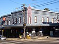
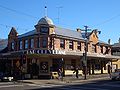
Until 1958, electric trams ran down the length of Cleveland Street, when they were replaced by motor buses. [17] The area between Crown and Bourke Streets is home to several pubs and an increasing number of restaurants.

Traffic volumes vary, depending on the segment of Cleveland Street. Near Prince Alfred Park the average traffic movements in 2016 for both east and west-bound vehicles was 17,500. Further east, between South Dowling Street and Anzac Parade, 2016 average traffic volumes peaked at 20,000 vehicles west-bound. [18]

Major intersections

Cleveland Street is entirely contained within the City of Sydney local government area.

Locationkm [1] miDestinationsNotes
CamperdownChippendaleDarlington tripoint0.00.0AUS Alphanumeric Route A36.svg City Road (A36)  Ultimo, Newtown Western terminus of street
ChippendaleDarlingtonRedfern tripoint0.50.31Abercrombie Street  Ultimo, Darlington One-way into Abercrombie Street northbound
ChippendaleRedfernSurry Hills tripoint0.80.50Regent Street  Ultimo, Redfern
Main Suburban railway line
RedfernSurry Hills boundary1.20.75Chalmers Street  Waterloo, Haymarket One-way northbound only
1.40.87 Elizabeth Street   Waterloo, Sydney CBD One-way southbound only
1.91.2 Crown Street   Woolloomooloo, Surry Hills
2.01.2Bourke Street  Woolloomooloo, Alexandria
RedfernSurry HillsMoore Park tripoint2.31.4South Dowling Street  Darlinghurst, Zetland
to AUS Alphanumeric Route M1.svgWestern Australia MR-SM-11.svg Eastern Distributor (M1)  Wahroongah, North Sydney, Kogarah, Heathcote, Sydney Airport
Moore Park 2.81.7 Anzac Parade   Paddington, Kingsford, La Perouse
Lang Road  Woollahra Eastern terminus of street

See also

Australia road sign W5-29.svg   Australian Roadsportal

Related Research Articles

<span class="mw-page-title-main">Surry Hills, New South Wales</span> Suburb of Sydney, New South Wales, Australia

Surry Hills is an inner-east suburb of Sydney, in the state of New South Wales, Australia. Surry Hills is immediately south-east of the Sydney central business district in the local government area of the City of Sydney. Surry Hills is surrounded by the suburbs of Darlinghurst to the north, Chippendale and Haymarket to the west, Moore Park and Paddington to the east and Redfern to the south. It is often colloquially referred to as "Surry".

<span class="mw-page-title-main">Great Western Highway</span> Highway in New South Wales

Great Western Highway is a 202-kilometre-long (126 mi) state highway in New South Wales, Australia. From east to west, the highway links Sydney with Bathurst, on the state's Central Tablelands.

<span class="mw-page-title-main">A6 (Sydney)</span>

The A6 is a route designation of a major metropolitan arterial route through suburban Sydney, linking Cumberland Highway at Carlingford and Princes Highway at Heathcote, via Lidcombe and Bankstown. This name covers a few consecutive roads and is widely known to most drivers, but the entire allocation is also known – and signposted – by the names of its constituent parts: Marsden Road, Stewart Street, Kissing Point Road, Silverwater Road, St Hilliers Road, Boorea Street, Olympic Drive, Joseph Street, Rookwood Road, Stacey Street, Fairford Road, Davies Road, Alfords Point Road, New Illawarra Road and Heathcote Road.

<span class="mw-page-title-main">Cumberland Highway</span> Highway in Sydney, New South Wales, Australia

Cumberland Highway is a 34-kilometre (21 mi) long urban highway located in Sydney, New South Wales, Australia. The highway links Pacific Highway and Pacific Motorway (M1) at Pearces Corner, Wahroonga in the northeast with Hume Highway at Liverpool in the southwest. This name covers a few consecutive roads and is widely known to most drivers, but the entire allocation is also known – and signposted – by the names of its constituent parts: Pennant Hills Road, James Ruse Drive, Briens Road, Old Windsor Road, Hart Drive, Freame Street, Emert Street, Jersey Road, Betts Road, Warren Road, Smithfield Road, Palmerston Road, (New) Cambridge Street, Joseph Street and Orange Grove Road. The entire length of Cumberland Highway is designated part of route A28.

<span class="mw-page-title-main">City West Link</span> Road in Sydney, Australia

City West Link is a 5.0-kilometre (3.1 mi) link road connecting Parramatta Road and the Western Distributor through the Inner West suburbs of Sydney, New South Wales, Australia. It was bypassed by the WestConnex project upon its completion in November 2023. This name covers a few consecutive roads and is widely known to most drivers, but the entire allocation is also known – and signposted – by the names of its constituent parts: Wattle Street, Dobroyd Parade, City West Link proper and The Cresent.

<span class="mw-page-title-main">Gore Hill Freeway</span> Freeway in Sydney, Australia

Gore Hill Freeway is a 4-kilometre (2.5 mi) divided freeway located in Sydney, New South Wales that is part of the Sydney Orbital Network and Highway 1. The primary function of the freeway is to provide an alternative high-grade route from Lane Cove to Naremburn and to reduce traffic demands on Pacific Highway throughout Sydney's lower north shore, bypassing St Leonards and Gore Hill.

<span class="mw-page-title-main">Eastern Distributor</span> Motorway in Sydney, Australia

The Eastern Distributor is a 4.7-kilometre-long (2.9 mi) motorway in Sydney, New South Wales, Australia. Part of the M1 and the Sydney Orbital Network, the motorway links the Sydney central business district with the south-east and Sydney Airport. The Eastern Distributor separates Sydney's Eastern Suburbs from Sydney's Inner-Southern Suburbs. The centre-piece is a 1.7 km (1.1 mi) tunnel running from Woolloomooloo to Surry Hills. Built as a build-own-operate-transfer project, it is 75.1% owned by Transurban.

<span class="mw-page-title-main">Alexandria Park Community School</span> School in New South Wales, Australia

Alexandria Park Community School is a New South Wales government-controlled school for secondary and primary students located on Gadigal country at Park Road, Alexandria, a south Sydney inner suburb, New South Wales, Australia. The school is a public-funded, partially academically selective, comprehensive, co-educational day school. cad In 2020, the school enrolled approximately 900 students, from Year K to Year 12. 18% of students identified as Indigenous Australians and 58% were from a language background other than English. Opportunity classes are delivered in Year 5 and Year 6, as well as a selective stream in Year 7 to Year 12 for academically gifted and talented students. The school is operated by the NSW government Department of Education in accordance with a curriculum developed by the New South Wales Education Standards Authority. The school principal is Diane Fetherston.

<span class="mw-page-title-main">Pennant Hills Road</span> Highway in Sydney, Australia

Pennant Hills Road is a 16.1-kilometre-long (10.0 mi) arterial road located in Sydney, New South Wales, Australia. The road links the suburb of Wahroonga in the northeast, to the major central business district of Parramatta in the southwest. Apart from a small section at its southwestern end, it is a constituent part of Cumberland Highway, and is designated part of route A28.

<span class="mw-page-title-main">Southern Cross Drive</span> Road in Sydney, Australia

Southern Cross Drive is a 4.8 km (3 mi) dual carriage untolled motorway in Sydney, New South Wales, Australia. Part of the M1 and Sydney Orbital Network, the road, a freeway that opened in 1969, links South Dowling Street at Kensington in the north to General Holmes Drive at Sydney Airport in the south.

<span class="mw-page-title-main">King Georges Road, Sydney</span> Road in Sydney, Australia

King Georges Road is a 9.0-kilometre-long (5.6 mi) major suburban arterial road through south-western Sydney, Australia. It is a constituent part of the A3 route.

<span class="mw-page-title-main">Anzac Parade, Sydney</span> Road in Sydney, Australia

Anzac Parade is a major road in the eastern suburbs of Sydney, Australia which travels south-east from the CBD, named in memory of members of the First Australian Imperial Force who marched down the street from their barracks to Sydney Harbour, where they were transported to Europe during World War I.

<span class="mw-page-title-main">Western Distributor (Sydney)</span> Motorway in New South Wales, Australia

Western Distributor is a 4.3-kilometre-long (2.7 mi) grade-separated motorway that is primarily elevated for the majority of its route on the western fringe of the Sydney central business district in New South Wales, Australia. It links the southern end of Bradfield Highway at the Sydney Harbour Bridge to Victoria Road in Rozelle, at its western terminus near White Bay. It is a constituent part of the A4 route.

<span class="mw-page-title-main">James Ruse Drive</span> Road in Sydney, Australia

James Ruse Drive is a 6.4-kilometre-long (4.0 mi) limited-access urban highway located to the east and north of Parramatta, in Western Sydney, New South Wales, Australia. Originally a series of disconnected urban streets, it was later upgraded to act as a bypass of central Parramatta.

Lane Cove Road is a 4.9-kilometre-long (3.0 mi) major suburban arterial road through North Ryde in Sydney, Australia. It is a constituent part of the A3 route.

Epping Road is a 10-kilometre-long (6.2 mi) is a major arterial road linking the lower North Shore and Sydney central business district to the north western suburbs of the upper North Shore and Hills District of Sydney, New South Wales, Australia, being a major access road to the commercial, industrial and university areas of North Ryde and Macquarie Park.

<span class="mw-page-title-main">A8 (Sydney)</span> Road in New South Wales, Australia

The A8 is a route designation of a major metropolitan arterial route through suburban north-eastern Sydney. This name covers a few consecutive roads and is widely known to most drivers, but the entire allocation is also known – and signposted – by the names of its constituent parts: Pittwater Road, Condamine Street, Burnt Bridge Creek Deviation, Manly Road, Spit Road and Military Road.

<span class="mw-page-title-main">Windsor Road</span> Road in Sydney, Australia

Windsor Road is a notable road in the Hills District of Sydney, linking Windsor and North Parramatta in Sydney's west. It is a constituent part of route A2.

<span class="mw-page-title-main">Old Windsor Road</span> Road in Sydney, Australia

Old Windsor Road is a notable and historic road in Sydney, Australia. It starts from Kellyville, New South Wales and ends at Northmead, New South Wales, just north of Parramatta, and acts as part of a main arterial between Parramatta and Windsor. A section at its southeastern end is a constituent part of Cumberland Highway.

<span class="mw-page-title-main">A38 (Sydney)</span>

The A38 is a route designation of a major metropolitan arterial route through suburban Sydney, linking M2 Hills Motorway in North Ryde and Pittwater Road (A8) in Dee Why. This name covers a few consecutive roads and is widely known to most drivers, but the entire allocation is also known – and signposted – by the names of its constituent parts: Delhi Road, Millwood Avenue, Fullers Road, Pacific Highway, Boundary Street, Babbage Road and Warringah Road.

References

  1. 1 2 Google (9 September 2021). "Cleveland Street, Sydney" (Map). Google Maps . Google. Retrieved 9 September 2021.
  2. 1 2 "Main Roads Act, 1924-1931". Government Gazette of the State of New South Wales. No. 34. National Library of Australia. 3 March 1933. p. 884. Archived from the original on 14 May 2023. Retrieved 21 June 2023.
  3. Annable, Rosemary (1991). Cleaveland House; An Archaeological Assessment. p. 12.
  4. Lawrence, Joan (2011). Cleveland House, Surry Hills, Sydney (a history).
  5. "Cleveland House". New South Wales State Heritage Register . Department of Planning & Environment. H00065. Retrieved 13 October 2018. CC BY icon.svg Text is licensed by State of New South Wales (Department of Planning and Environment) under CC-BY 4.0 licence .
  6. "Sydney's Streets: A guide to Sydney street names" (Downloadable Excel). City of Sydney. n.d. Retrieved 23 March 2023.
  7. State of New South Wales, An Act to provide for the better construction, maintenance, and financing of main roads; to provide for developmental roads; to constitute a Main Roads Board Archived 11 August 2022 at the Wayback Machine 10 November 1924
  8. State of New South Wales, An Act to amend the Main Roads Act, 1924-1927; to confer certain further powers upon the Main Roads Board; to amend the Local Government Act, 1919, and certain other Acts; to validate certain payments and other matters; and for purposes connected therewith. Archived 12 August 2022 at the Wayback Machine 8 April 1929
  9. "Main Roads Act, 1924-1963". Government Gazette of the State of New South Wales. No. 137. National Library of Australia. 4 December 1964. p. 3910. Archived from the original on 15 May 2023. Retrieved 21 June 2023.
  10. State of New South Wales, An Act to make provision with respect to the roads of New South Wales; to repeal the State Roads Act 1986, the Crown and Other Roads Act 1990 and certain other enactments; and for other purposes. Archived 11 August 2022 at the Wayback Machine 10 November 1924
  11. Transport for NSW (August 2022). "Schedule of Classified Roads and Unclassified Regional Roads" (PDF). Government of New South Wales. Archived from the original (PDF) on 25 August 2022. Retrieved 1 August 2022.
  12. "CSIEHS Website-History". Archived from the original on 17 December 2003. Retrieved 22 February 2015.
  13. "Cleveland Street Public School". Dictionary of Sydney. State Library of New South Wales. 2021. Retrieved 23 March 2023.
  14. "CSIEHS Website-History-Memorabilia". Archived from the original on 22 February 2015. Retrieved 22 February 2015.
  15. "Inner Sydney High School – Cleveland and Chalmers Street, Surry Hills". Northrop Engineering. 2022. Retrieved 23 March 2023.
  16. Proctor, H, Sriprakash, A., "Selective schools' long and tangled history with race and class", Sydney Morning Herald, 29 March 2017
  17. Keenan, D. (1979). Tramways of Sydney. Transit Press.
  18. "Cleveland Street: 02038". Traffic volume viewer. Roads & Maritime Services. 2016. Retrieved 3 October 2016.
Template:Attached KML/Cleveland Street, Sydney
KML is from Wikidata