Kingsford is a mainly residential area, situated directly south of the University of New South Wales, which is in Kensington. Many of the residents are students living in medium and high density housing. A large Australian Army depot lies in the east of Kingsford. Kingsford surrounded by Daceyville to the south, Eastlakes to the west, Randwick to the north, and Maroubra to the south,
At the centre of Kingsford, on Anzac Parade and Gardeners Road, there was a large roundabout connecting a public transport system to nine possible destinations via a large number of bus services. For this reason, this part of Kingsford is sometimes referred to as "nine-ways". Due to construction on light rail, the roundabout has since been converted into an intersection with traffic lights.
History
The area was originally known as South Kensington. In 1936 it was renamed Kingsford to honour Australian aviator Sir Charles Kingsford Smith (1897–1935), as was the nearby Sydney Airport. Kingsford was undeveloped until a land boom in the 1920s.
On 19 December 1936, the coffin of Eileen O'Connor, who was likely to become Australia's second Catholic saint,[2] was opened in a funeral home at 347 Anzac Parade, Kingsford. The body was found to be incorrupt although Eileen had died in 1921. The body was reinterred in the Coogee home of Our Lady's Nurses for the Poor, an order which Eileen had founded.[3]
In the 1940s, many Greeks settled in the area, particularly migrants from the island of Castellorizo (or Kastellorizo). Many opened businesses in the area; and, in 1973, they built the Castellorizian Club on Anzac Parade. Kingsford was originally intended to be the terminus of the Eastern Suburbs railway line; but, as a cost-cutting measure, the line was terminated at Bondi Junction in 1979.[4] A new light rail project linking Kingsford to the CBD via Anzac Parade opened in April 2020.[5]
Charles Kingsford Smith Tribute
In 2010, a tribute was created to Charles Kingsford Smith in Gardeners Lane, off Anzac Parade. The tribute consisted of a mosaic of Smith, a mosaic of his plane, the Southern Cross, and a Trans Pacific Mural depicting the Southern Cross. The tribute was unveiled on 11 August 2010 by Mayor John Procopiadis. It was designed by Masoud Nodous; the artist was Tim Cole. In 2014, the mural depicting the Southern Cross was added. The artist was Annette Barlow.[citation needed]
Charles Kingsford Smith Tribute, Gardeners Lane
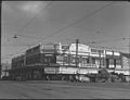
Maloneys Corner Kingsford in 1951
Demographics
In the 2021 Census, there were 13,492 people in Kingsford. 46.4% of people were born in Australia. The next most common countries of birth were China 8.3%, Indonesia 4.3%, India 2.8%, England 2.8% and Malaysia 2.5%. The most common ancestries in Kingsford were Chinese 20.8%, English 17.5%, Australian 16.7%, Irish 9.1% and Greek 8.8%. 51.2% of people only spoke English at home. Other languages spoken at home included Mandarin 9.8%, Greek 6.0%, Indonesian 4.0%, Cantonese 3.7% and Spanish 2.1%. The most common responses for religion were No Religion, so described 34.6%, Catholic 22.0%, Eastern Orthodox 9.0% and Anglican 5.4%.[6]
↑"Kingsford Light Rail". Transport for NSW. Anzac Pde, Kingsford. Archived from the original on 4 March 2024. Retrieved 4 March 2024.
↑"Profile of the electoral division of Kingsford Smith (NSW)". Australian Electoral Commission. 19 November 2019. Archived from the original on 4 March 2024. Retrieved 4 March 2024. Kingsford Smith covers an area from La Perouse in the south to Randwick and Coogee in the north. The main suburbs include Banksmeadow, Botany, Chifley, Clovelly (part), Coogee, Daceyville, Eastgardens, Eastlakes, Hillsdale, Kensington, Kingsford, La Perouse, Little Bay, Malabar, Maroubra, Mascot, Matraville, Pagewood, Phillip Bay, Port Botany, Randwick (part) and South Coogee.
↑"The Legislative Assembly District of Maroubra". NSW Electoral Commission. 4 October 2023. Archived from the original on 4 March 2024. Retrieved 4 March 2024. Banksmeadow, Botany, Chifley, Daceyville, Eastgardens, Eastlakes, Hillsdale, Kingsford, La Perouse, Little Bay, Malabar, Maroubra, Matraville, Pagewood, Phillip Bay, Randwick, South Coogee.
↑"The Legislative Assembly District of Coogee". 4 October 2023. Archived from the original on 4 March 2024. Retrieved 4 March 2024. Bondi, Bondi Junction, Bronte, Clovelly, Coogee, Kensington, Kingsford, Queens Park, Randwick, South Coogee, Tamarama, University Of Nsw, Waverley.
↑"Suburbs"(PDF). Randwick City Council. 29 March 2018. Archived(PDF) from the original on 28 October 2023. Retrieved 4 March 2024.
This page is based on this Wikipedia article Text is available under the CC BY-SA 4.0 license; additional terms may apply. Images, videos and audio are available under their respective licenses.