Little Bay, New South Wales

Last updated

Little Bay
Sydney,  New South Wales
The Coast Golf Course Little Bay.JPG
The Coast Golf Course, Little Bay
Little Bay, New South Wales
Population2,937 (2011 census) [1]
Postcode(s) 2036
Elevation39 m (128 ft)
Location14 km (9 mi) south-east of Sydney CBD
LGA(s) City of Randwick
State electorate(s) Maroubra
Federal division(s) Kingsford Smith
Suburbs around Little Bay:
Matraville Chifley Malabar
Phillip Bay Little Bay Tasman Sea
La Perouse La Perouse
Partially buried gun emplacement that formed part of Fort Banks 1aBanksbatrycapebnks0037.JPG
Partially buried gun emplacement that formed part of Fort Banks

Little Bay is a suburb in south-eastern Sydney, in the state of New South Wales, Australia. Little Bay is located 14 kilometres south-east of the Sydney central business district and is part of the local government area of the City of Randwick.

Contents

Little Bay is a coastal suburb, to the north of Botany Bay. The suburb takes its name from the geographical formation called Little Bay, which also features a small beach. The Prince Henry Hospital was a famous landmark once located at Little Bay.

History

The Little Bay area was first used as a sanitation camp during Sydney's smallpox outbreak in 1881–82, to isolate the healthy contacts of sufferers of the disease. At first, a "tent city" was established on the beach, but as well the government decided to build a permanent hospital here to treat infectious diseases. Little Bay was an ideal location because it was isolated from settlements but still close enough to Sydney. The Coast Hospital was particularly valuable during the bubonic plague in Sydney of 1900 and then again when soldiers returning from Europe brought the influenza virus back in 1919. The Coast Hospital became Prince Henry Hospital in 1934. In 2001 services were transferred to Prince of Wales Hospital, Sydney and the hospital site became available for residential use. [2]

There are still nineteen heritage listed buildings on site from the Coast/Prince Henry days.

Two landmarks still remain from the hospital days. One is the Coast Cemetery, situated south of Little Bay. Some two thousand five hundred plus people were buried there, with the oldest graves being located further south, towards Cape Banks. The cemetery was taken over by the National Parks and Wildlife Service of New South Wales when the Botany Bay National Park was created. Most of the graves are now under vegetation to protect them.

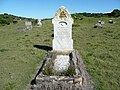
Another landmark is the Interdenominational War Memorial Chapel, which overlooks Little Bay. It was destroyed by fire in October 1981, but was subsequently rebuilt in 1982. Outside the chapel there is an array of memorial plaques dedicated to former staff of the hospital.

Little Bay was originally called Yarra Junction but mail would end up in Melbourne (Vic) so the residents asked for the suburb's name to be changed. This was granted and changed to Phillip Bay Heights (Phillip Bay is a suburb located between Little Bay and Botany Bay) but as everyone called the area Little Bay this was the name that was eventually officially adopted. During the 1950s, much of the land was provided to returned servicemen via War Ballots.

In 1969, the international artists Christo and Jeanne-Claude created the world's largest sculpture at Little Bay called: "Wrapped Coast – One Million Square Feet, Little Bay, Sydney, Australia". Many Australian artists and students volunteered to assist them wrapping 2.4 kilometres of coastline, which was 46 to 244 metres wide, up to 26 metres high at the northern cliffs, and at sea level at the southern sandy beach. It introduced a radical work of art which at the time was controversial and polarised the community. It marked the beginning of a new chapter of contemporary art in Australia and today is considered a triumphant project. Christo and Jeanne-Claude went on to wrap cars, galleries, islands, and even the Reichstag building in Germany. [3]

Heritage listings

Little Bay has a number of heritage-listed sites, including:

Little Bay Beach

Little Bay Beach at sunset. Little Bay Beach, New South Wales, Australia.jpg
Little Bay Beach at sunset.

In the stretch of coastline south of Sydney Harbour (Port Jackson), Little Bay Beach is the last significant sand beach before Botany Bay. Little Bay took its name from the obvious comparison to nearby Long Bay at Malabar. On the evening of 3 December 1797, George Bass, at the commencement of his first major voyage of discovery in the waters of southern Australia, anchored there in his open whaleboat with a crew of six, [5] referring to it in his journal as Little Harbour.

Little Bay beach is semi-circular in shape and enclosed by headlands to the south and north. Its narrow entrance provides significant shelter from prevailing sea conditions.

A ring-of-rocks bathing pool known as Little Bay Rock Pool or Little Bay Baths was created from beach rocks at the southern end of the beach in the early 1900s to provide safe shark-free bathing for nurses resident nearby at the Coast Hospital. The pool is still partially intact.

Little Bay is not a surf beach and does not have an undertow or "rip" unless there is a strong sea from the south or south-east running into the bay. The beach is not patrolled by lifesavers. However surf lifesavers and the Westpac Life Saver Rescue Helicopter Service attend to incidents. Rock fishing is very popular along the rocky coastline to the north and south of Little Bay, but it is also very dangerous with deaths occurring occasionally. Information on water safety at Little Bay is provided on the Little Bay Beach web site. [6]

In February 2022, a 35-year-old expatriate British diving instructor was killed by a white shark while swimming off Little Bay Beach. He was the first person killed by a shark in Sydney coastal waters since the death of Marcia Hathaway in 1963. [7]

Pollution

As the population of Sydney grew, the beaches south of the Malabar sewage treatment plant such as Little Bay, became increasingly polluted. By the 1980s, the water was brown and fat was deposited on the sand and rocks, making them slimy and smelly. After the Malabar Deep Ocean Outfall commenced operation in 1990, the beaches to the south became significantly cleaner within a very short period of time. [8] Today, Little Bay is consistently one of the cleanest beaches in Sydney, in terms of water clarity and bacteria counts. [9]

Landmarks

The north headland of Botany Bay (Henry Head) has a number of features, including two old gun emplacements at Fort Banks, and an unattended lighthouse and the wreck of the SS Minmi [10] on what is called Pussycat Island. The older of the gun emplacements, known as the Henry Head Battery was originally built just after the completion of Bare Island to provide additional coverage of the entrance to Botany Bay.

Notable residents

Street names

Many street names in Little Bay were derived from Aboriginal words or eminent people, especially those associated with medicine through the presence of the former Prince Henry Hospital.

NameDerivation
Abbe Receveur PlaceNamed after Louis Receveur, a Franciscan friar and scientist who sailed with La Perouse
Alkoo AvenueAboriginal word meaning "visitor"
Anzac ParadeNamed to commemorate the occasion when the First Australian Imperial Force camped at Kensington Racecourse
Bega AvenueAboriginal word meaning "large camping ground"
Binda CrescentAboriginal word meaning "deep water"
Brodie AvenueNamed after surgeon Sir Benjamin Collins Brodie
Budd AvenueNamed after an early female resident
Bunnerong RoadAboriginal word meaning "sleeping lizard"
Clonard Way
Coast Hospital RoadNamed after The Coast Hospital, the original name for Prince Henry Hospital
Cove Circuit
Curie StreetNamed after Pierre and Marie Curie
Darwin AvenueNamed after naturalist Charles Darwin
Dawes AvenueNamed after Lieutenant William Dawes who was on the First Fleet
Dwyer AvenueNamed after Matt Dwyer, former Mayor of Randwick
Esperance Close
Ewing AvenueNamed after pathologist James Ewing
Fleming StreetNamed after bacteriologist Alexander Fleming
Florey CrescentNamed after pharmacologist and pathologist Howard Florey
Gipps AvenueNamed after Sir George Gipps, former Governor of NSW
Goora StreetAboriginal word meaning "long" or "tall"
Grose StreetNamed after Francis Grose, first Lieutenant-Governor of NSW
Gubbuteh RoadAboriginal word meaning "ochre", named after local ochre deposits
Gull StreetNamed after physician Sir William Gull
Harvey StreetNamed after physician William Harvey
Jenner StreetNamed after surgeon Edward Jenner
Jennifer Street
Lister AvenueNamed after surgeon Joseph Lister
Little Bay RoadNamed after nearby Little Bay
Marconi PlaceNamed after Guglielmo Marconi, Italian physicist who developed the wireless telegraph
Mayo StreetNamed after physician William Worrall Mayo
McMaster PlaceNamed after Jean McMaster who established the Nurses' Training School at Prince Henry Hospital
Meyler CloseNamed after Mary Meyler, first matron of Prince Henry Hospital
Millard DriveNamed after Dr Reginald Millard, medical superintendent at The Coast Hospital
Mirrabooka CrescentAboriginal word for the "Southern Cross"
Murra Murra PlaceAboriginal word meaning "sea mullet"
Newton StreetNamed after Sir Isaac Newton
Noora AvenueAboriginal word meaning "camp"
Nurla AvenueAboriginal word meaning "plenty"
Pavilion DriveNamed after the pavilion wards at Prince Henry Hospital that allowed fresh air to circulate around infectious patients
Pine AvenueNamed because Norfolk Island pine trees were predominant in the grounds of Prince Henry Hospital
Reservoir StreetNamed because there is a water reservoir nearby
Woomera RoadAboriginal word – see woomera
Woonah Street

Sources:

Transport

Little Bay is served by five bus services operated by Transdev John Holland:

Route numberFromToServiceTimetable
390X La Perouse Bondi Junction railway station Express Route 390X timetable
392Little Bay Redfern railway station Regular Route 392 timetable
392XLittle Bay Museum railway station Express Route 392X timetable
394XLa PerouseMuseum railway stationExpress Route 394X timetable
399Little Bay University of New South Wales Regular Route 399 timetable

Sport and recreation

Related Research Articles

<span class="mw-page-title-main">Mascot, New South Wales</span> Suburb of Sydney, New South Wales, Australia

Mascot is a suburb in the Inner-South of Sydney, in the state of New South Wales, Australia. Mascot is located 7 kilometres south of the Sydney central business district and is one of the administrative centres of the Bayside Council. A small part of Mascot is located in the Inner West Council. Mascot is on the north-west side of Botany Bay and contains Sydney Airport.

<span class="mw-page-title-main">La Perouse, New South Wales</span> Suburb of Sydney, New South Wales, Australia

La Perouse is a suburb in south-eastern Sydney, in the state of New South Wales, Australia. The suburb of La Perouse is located about 14 kilometres (8.7 mi) southeast of the Sydney central business district, in the City of Randwick.

<span class="mw-page-title-main">Botany, New South Wales</span> Suburb of Sydney, New South Wales, Australia

Botany is a suburb in the Eastern Suburbs of Sydney, in the state of New South Wales, Australia. Botany is located 11 kilometres south of the Sydney central business district and is part of the Bayside Council.

<span class="mw-page-title-main">Palm Beach, New South Wales</span> Suburb of Sydney, New South Wales, Australia

Palm Beach is a suburb in the Northern Beaches region of Sydney, in the state of New South Wales, Australia. Palm Beach is located 41 kilometres (25 mi) north of the Sydney central business district, in the local government area of Northern Beaches Council. Palm Beach sits on a peninsula at the end of Barrenjoey Road, between Pittwater and Broken Bay. The population of Palm Beach was 1,593 as at the 2016 census.

<span class="mw-page-title-main">Torquay, Victoria</span> Town in Victoria, Australia

Torquay is a seaside resort in Victoria, Australia, which faces Bass Strait, 21 km south of Geelong and is the gateway to the Great Ocean Road. It is bordered on the west by Spring Creek and its coastal features include Point Danger and Zeally Bay. At the 2021 census, Torquay had a population of 18,534.

<span class="mw-page-title-main">Randwick, New South Wales</span> Suburb of Sydney, New South Wales, Australia

Randwick is a suburb of Sydney, in the state of New South Wales, Australia. Randwick is located 6 kilometres south-east of the Sydney central business district and is the administrative centre for the local government area of the City of Randwick. Randwick is part of the Eastern Suburbs of Sydney. The postcode is 2031.

<span class="mw-page-title-main">Sutherland Shire</span> Local government area in New South Wales, Australia

Sutherland Shire is a local government area in the southern region of Sydney, in the state of New South Wales, Australia. Sutherland Shire comprises an area of 370 square kilometres (140 sq mi) and as at the 2016 census had an estimated population of 218,464. Sutherland Shire is colloquially known as "The Shire" and has featured in several reality television series.

<span class="mw-page-title-main">Cronulla, New South Wales</span> Suburb of Sydney, New South Wales, Australia

Cronulla is a suburb of Sydney, in the state of New South Wales, Australia. Boasting numerous surf beaches and swimming spots, the suburb attracts both tourists and Greater Sydney residents. Cronulla is located 26 kilometres south of the Sydney central business district, in the local government area of the Sutherland Shire.

<span class="mw-page-title-main">Coogee, New South Wales</span> Suburb of Sydney, Australia

Coogee is a beachside suburb of local government area City of Randwick 8 kilometres south-east of the Sydney central business district, in the state of New South Wales, Australia. Coogee is in the Eastern Suburbs of Sydney.

<span class="mw-page-title-main">Division of Kingsford Smith</span> Australian federal electoral division

The Division of Kingsford Smith is an Australian electoral division in the state of New South Wales.

<span class="mw-page-title-main">Prince of Wales Hospital (Sydney)</span> Hospital in New South Wales, Australia

The Prince of Wales Hospital is a 440-bed major public teaching hospital located in Sydney's eastern suburb of Randwick, providing a full range of hospital services to the people of New South Wales, Australia. The hospital has strong ties to the University of New South Wales. The Prince of Wales Hospital shares the Randwick Hospitals' Campus site with the Royal Hospital for Women and the Sydney Children's Hospital, as well as the Prince of Wales Private Hospital.

<span class="mw-page-title-main">Maroubra, New South Wales</span> Suburb of Sydney, New South Wales, Australia

Maroubra is a beachside suburb in the Eastern Suburbs of Sydney, in the state of New South Wales, Australia. It is 10 kilometres south-east of the Sydney central business district in the local government area of the City of Randwick.

<span class="mw-page-title-main">Malabar, New South Wales</span> Suburb of Sydney, New South Wales, Australia

Malabar is a suburb in the Eastern Suburbs of Sydney, in the state of New South Wales, Australia 12 kilometres south-east of the Sydney central business district, in the local government area of the City of Randwick.

<span class="mw-page-title-main">Kurnell, New South Wales</span> Suburb of Sydney, New South Wales, Australia

Kurnell is a suburb in Sydney, in the state of New South Wales, Australia. It is 21.4 kilometres (13.3 mi) south of the Sydney central business district, in the local government area of the Sutherland Shire along the east coast. Cronulla and Woolooware are the only adjacent suburbs. La Perouse is located opposite, on the northern headland of Botany Bay. The Cronulla sand dunes are on the south eastern headland of Botany Bay. The eastern side of the peninsula is part of Botany Bay National Park, and Towra Point Nature Reserve is located on the western side of the suburb.

<span class="mw-page-title-main">Clovelly, New South Wales</span> Suburb of Sydney, New South Wales, Australia

Clovelly is a small beach-side suburb in Sydney's Eastern Suburbs, in the state of New South Wales, Australia. Clovelly is located 8 kilometres south-east of the Sydney central business district, in the local government area of the City of Randwick, within the Federal Division of Wentworth.

<span class="mw-page-title-main">Woonona, New South Wales</span> Suburb of Wollongong, New South Wales, Australia

Woonona is a northern suburb of Wollongong, New South Wales, Australia, south of Sydney. It is served by Woonona Station on the South Coast (Illawarra) Line, and by the Princes Highway.

<span class="mw-page-title-main">Shelly Beach, Central Coast New South Wales</span> Suburb of Central Coast, New South Wales, Australia

Shelly Beach is a coastal suburb of the Central Coast region of New South Wales, Australia, located east of Tuggerah Lake and bordering the Pacific Ocean south of The Entrance. It is part of the Central Coast Council local government area. It is 66 km south of Newcastle & 93 km north of Sydney. Shelly Beach is considered one of the most popular surfing beaches on the Central Coast.

<span class="mw-page-title-main">Malabar Headland</span> Historic site in New South Wales, Australia

The Malabar Headland is a heritage-listed former public recreation area and military installation site and now nature conservation and public recreation headland area located at Franklin Street, Malabar in the City of Randwick local government area of New South Wales, Australia. It is also known as Long Bay Rifle Range, Anzac Rifle Range and Boora Point. The property is owned by the New South Wales Government. It was added to the New South Wales State Heritage Register on 22 July 2005.

<span class="mw-page-title-main">Prince Henry Hospital, Sydney</span> Historic site in New South Wales, Australia

The Prince Henry Hospital site, formerly known as the Prince Henry Hospital, Sydney, is a heritage-listed former teaching hospital and infectious diseases hospital and now UNSW teaching hospital and spinal rehabilitation unit located at 1430 Anzac Parade, Little Bay, City of Randwick, New South Wales, Australia. It was designed by NSW NSW Colonial Architect and NSW Government Architect and built from 1881 by NSW Public Works Department. It is also known as Prince Henry Hospital and The Coast Hospital. The property is owned by Landcom, an agency of the Government of New South Wales. It was added to the New South Wales State Heritage Register on 2 May 2003.

References

  1. Australian Bureau of Statistics (31 October 2012). "Little Bay (State Suburb)". 2011 Census QuickStats. Retrieved 20 April 2015. OOjs UI icon edit-ltr-progressive.svg
  2. The Book of Sydney Suburbs, Compiled by Frances Pollon, Angus & Robertson Publishers, 1990, ISBN   0-207-14495-8, p.155
  3. McGregor, Adrian (27 October 2019). "From the Archives, 1969: Christo wraps Little Bay". The Sydney Morning Herald.
  4. "Prince Henry Site". New South Wales State Heritage Register . Department of Planning and Environment. H01651. Retrieved 18 May 2018. CC-BY icon.svg Text is licensed by State of New South Wales (Department of Planning and Environment) under CC-BY 4.0 licence .
  5. Estensen, Miriam The Life of George Bass: Surgeon and Sailor of the Enlightenment. Allen & Unwin, 2005 (hardcover ISBN   1-74114-130-3)
  6. "Water safety". 13 April 2013.
  7. "'Nicest, kindest human': Diving instructor killed in Sydney shark attack remembered". www.9news.com.au. Retrieved 18 February 2022.
  8. Weekly Southern Courier (newspaper) 30 October 1990
  9. "Beaches". NSW Environment, Energy and Science.
  10. "Michael McFadyen's Scuba Diving Web Site". www.michaelmcfadyenscuba.info.
  11. "SCIA | Home". SCIA.
  12. "Aboriginal Health College, Little Bay | The Dictionary of Sydney". dictionaryofsydney.org.
  13. PRINCE HENRY | at little bay Archived 28 August 2007 at the Wayback Machine
  14. Latest Coastal Weather Observations Little Bay
  15. Manly, Lucy (25 May 2019). "The incestuous world of Sydney rich kids". The Sydney Morning Herald.
  16. "Rabbitoh's legend Greg Inglis sells Coogee home after reducing price guide". www.propertyobserver.com.au. 2 June 2019.
  17. Tingle, Greg. "Tony Rafty: Caricaturist and Australian National Treasure". mediaman.com.au. Retrieved 11 September 2010.
  18. Levi, Joshua (26 August 2008). "Saville hangs up shoes". Archived from the original on 5 March 2011. Retrieved 11 September 2010.
  19. Bunbury, Bill (30 March 2008). "Encounter". abc.net.au. Retrieved 11 September 2010.
  20. Rothfield, Phil (1 December 2013). "RUMOUR MILL". The Sunday Telegraph. Retrieved 7 January 2014.
  21. Welcome to St. Michael's Golf Club
  22. The Coast Golf Club

Coordinates: 33°58′50″S151°14′35″E / 33.98056°S 151.24306°E / -33.98056; 151.24306