Related Research Articles

Botany is a suburb in the Inner Southern Suburbs of Sydney, in the state of New South Wales, Australia. Botany is located 11 kilometres south of the Sydney central business district and is part of the Bayside Council.

Cronulla is a suburb of Sydney, in the state of New South Wales, Australia. Boasting numerous surf beaches and swimming spots, the suburb attracts both tourists and Greater Sydney residents. Cronulla is 26 kilometres south of the Sydney central business district, in the local government area of the Sutherland Shire.

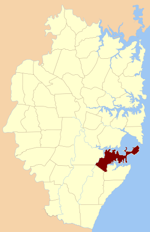
The Division of Cook is an Australian electoral division in the State of New South Wales.

Cremorne Point is a harbourside suburb on the Lower North Shore of Sydney, New South Wales, Australia located six kilometres north of the Sydney central business district, in the local government area of North Sydney Council.

Taren Point is a small waterfront suburb, in southern Sydney, in the state of New South Wales, Australia 18 kilometres south of the Sydney central business district in the local government area of the Sutherland Shire.

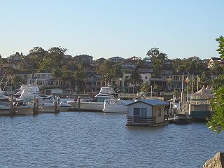
Sylvania Waters is a suburb in southern Sydney located in the state of New South Wales, Australia, 21 kilometres south of the Sydney central business district in the local government area of Sutherland Shire.
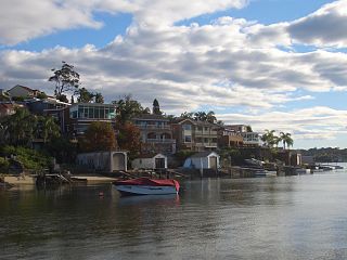
Sylvania is a suburb in southern Sydney, New South Wales, Australia, 22 kilometres south of the Sydney central business district in the Sutherland Shire. It is well known for its large waterfront properties and restaurants.
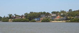
Kangaroo Point is a tiny suburb in southern Sydney, in the state of New South Wales, Australia. It is 22 kilometres south of the Sydney central business district in the local government area of the Sutherland Shire.

Banksmeadow is a suburb located in the Eastern Suburbs of Sydney, within the state of New South Wales, Australia. Situated 11 kilometres south of the Sydney central business district, it falls under the jurisdiction of the Bayside Council. Banksmeadow is positioned on the northern shores of Botany Bay.

Hen and Chicken Bay is a bay on the Parramatta River, in the inner-west of Sydney, in the state of New South Wales, Australia. It lies approximately eight kilometres (5.0 mi) due west of Sydney's central business district. It is surrounded by the suburbs of Abbotsford, Drummoyne, Wareemba, Five Dock, Canada Bay, Concord and Cabarita.
Blakehurst is a suburb in southern Sydney, in the state of New South Wales, Australia 18 kilometres south of the Sydney central business district, in the local government area of the Georges River Council. It is part of the St George area.

Bate Bay is a bay in Southern Sydney, Australia. The bay is south of the Kurnell peninsula and its foreshore makes up the beaches of Cronulla.
The state parks of New South Wales are 18 protected areas in New South Wales, Australia reserved for camping, water sports and recreational uses. State parks are maintained by the New South Wales Department of Lands and managed by community trust boards.
The Parish of Sutherland is one of the 57 parishes in Cumberland County, New South Wales, a cadastral unit for use on land titles. It was originally proclaimed as the parish of Southerland with an 'o', but was misspelled without it on the government gazette. It includes all of the Kurnell peninsula, with Botany Bay and the Georges River to the north; part of the Woronora River to the west; and Port Hacking to the south. Suburbs within the parish include Cronulla, Miranda, Woolooware, Caringbah, Gymea, Sutherland, Sylvania Waters and Oyster Bay.
Sylvania High School is a high school situated in the Sutherland Shire, in the Southeast region of Sydney, New South Wales. 793 students.

Riverview is a suburb on the Lower North Shore of Sydney, New South Wales, Australia. It is located nine kilometres north-west of the Sydney central business district, in the local government area of the Municipality of Lane Cove. It is situated on the northern side of the Lane Cove River, at the head of Tambourine Bay; the foreshore is occupied by Tambourine Bay Park. Riverview is primarily a residential area.

Berrys Bay is a bay located to the east of the Waverton Peninsula and the west of McMahons Point, on the north of Sydney Harbour.
The Commissioners Waters, a watercourse that is part of the Macleay River catchment, is located in the Northern Tablelands region of New South Wales, Australia.

The Woolooware Bay is a bay on the lower estuarine Georges River in southern Sydney, in the state of New South Wales, Australia.
Weeney Bay is a bay in Botany Bay located in New South Wales, Australia.
References
- ↑ Geographical Names Board of New South Wales. "Gwawley Bay" . Retrieved 28 September 2015.
34°00′56″S151°06′53″E / 34.0156°S 151.1146°E
| | This article about a specific Australian geological feature is a stub. You can help Wikipedia by expanding it. |
| | This article related to the geography of Sydney is a stub. You can help Wikipedia by expanding it. |