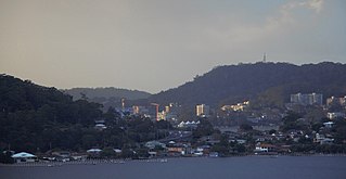
Gosford is a waterfront city on the northern extremity of Brisbane Water in the Central Coast Council local government area in the heart of the Central Coast in New South Wales, Australia. Gosford is known for sailing and boating as well as scenic views on the foreshore of Brisbane Water and the surrounding valleys. It is situated 77 km (48 mi) north of Sydney and 86 km (53 mi) south of Newcastle. Gosford is the administrative and commercial centre as well as the gateway of the Central Coast.

The Central Coast is a peri-urban region lying on the Pacific Ocean in northern-eastern New South Wales, Australia. The region is situated north of Sydney, which is filled with subtropical national parks, forests and also encompasses the coastal waterways of Brisbane Water, Tuggerah Lakes and southern Lake Macquarie. The region’s hinterland which has fertile valleys, rural farmland and wineries, which also includes the Watagan Mountains. The Central Coast is known for its regional coastal towns like Terrigal, The Entrance, Ettalong Beach, Budgewoi and Bateau Bay with resorts and holiday parks, which does feature many expansive beaches and lagoons with surfing and coastal tracks, as well as scenic views. Gosford is the main commercial centre and gateway.

Brisbane Water is a wave-dominated barrier estuary located in the Central Coast region of New South Wales, Australia. Brisbane Water has its origin at the confluence of the Narara and Coorumbine Creeks, to the south–east of Gosford and travels for approximately 18 kilometres (11 mi) in a southerly direction to its mouth at Broken Bay, about 7 kilometres (4.3 mi) from the Tasman Sea, at Barrenjoey Head. A number of towns and suburbs surround the shores of Brisbane Water, including Blackwall, Booker Bay, Davistown, Empire Bay, Erina, Ettalong Beach, Gosford, Green Point, Hardys Bay, Kilcare, Kincumber, Koolewong, Phegans Bay, Point Frederick, Point Clare, Saratoga, Tascott, Wagstaffe, and Woy Woy. Contained within Brisbane Water is St Huberts Island, Rileys Island, Dunmar Island and Pelican Island; and adjoining the estuary is Brisbane Water National Park to the west and Bouddi National Park to the east. Forming part of the same tidal estuary system is a separate but connected basin, the Kincumber Broadwater, lying to the east of Davistown.

Woy Woy railway station is located on the Main Northern line in New South Wales, Australia. It serves the southern Central Coast suburb of Woy Woy opening on 1 February 1889.

Woy Woy is a coastal town in the Central Coast region of New South Wales, Australia, located on the southern reaches of Brisbane Water 79 km (49 mi) north of Sydney. It is a population centre within the Central Coast Council local government area.
Umina Beach is a suburb within the Central Coast Council local government area on the Central Coast of New South Wales, Australia. Umina Beach is situated 85 kilometres (53 mi) north of Sydney and 111 kilometres (69 mi) south of Newcastle.

Toowoon Bay is a suburb of the Central Coast region of New South Wales, Australia, located on a peninsula between Tuggerah Lake and the Pacific Ocean south of The Entrance. It is part of the Central Coast Council local government area.

Ettalong Beach is a suburb of the Central Coast region of New South Wales, Australia south of Woy Woy on Brisbane Water at the point where it meets Broken Bay, about 86 km north of Sydney. It is part of the Central Coast Council local government area. Ettalong Beach is the natural eastward continuation of Umina Beach and Ocean Beach. The village is serviced by a small retail centre along Ocean View Road.
Phegans Bay is a suburb within the local government area of the Central Coast Council on the Central Coast of New South Wales, Australia.

Wagstaffe is a south-eastern suburb of the Central Coast region of New South Wales, Australia on the Bouddi Peninsula. It is part of the Central Coast Council local government area. It was named after Captain Wagstaffe, one of the first settlers in the area. It has a general store, which is also the local post office. It is a thin slither of around 200 houses between the bay and the bush(Bouddi National Park). Historically it was also known as Wagstaffe Point. In aboriginal dialect the point is called Kourang Gourang. A ferry service operates between Wagstaffe and Palm Beach(via Ettalong). Travel time is 30 minutes.
Central Coast Ferries is an Australian ferry operator on the Central Coast of New South Wales.

Ungarie is a town in New South Wales, Australia which is the second major town of the Bland Shire, located in the Central West region of New South Wales. It is located 513 kilometres (319 mi) west of Sydney and 615 kilometres (382 mi) north of Melbourne, between the towns of West Wyalong and Lake Cargelligo and is situated 262 metres (860 ft) above sea level. The town's name is derived from an Indigenous Australian word meaning "thigh".

Woy Woy Bay is a suburb located in the Central Coast region of New South Wales, Australia, as part of the Central Coast Council local government area. Most of the suburb's area belongs to the Brisbane Water National Park, although a small community on Woy Woy Bay containing a community hall, public reserve and wharf is also located within the suburb. Woy Woy Bay is commonly used by boaters on the weekend because of the open expanses of the bay. The main thoroughfare is Taylor Street.

Postcodes in Australia are used to more efficiently sort and route mail within the Australian postal system. Postcodes in Australia have four digits and are placed at the end of the Australian address, before the country. Postcodes were introduced in Australia in 1967 by the Postmaster-General's Department and are now managed by Australia Post, Australia's national postal service. Postcodes are published in booklets available from post offices or online from the Australia Post website.

Cardwell Bush Telegraph is a heritage-listed former post office and now heritage centre at 53 Victoria Street, Cardwell, Cassowary Coast Region, Queensland, Australia. The Telegraph and Post Office at Cardwell was designed by Colonial Architect's Office and built in 1870 by George McCallum, making it one of the oldest buildings in North Queensland.
Trevor Alfred Housley was a senior Australian public servant. He was Director-General of the Postmaster-General's Department from 1965 until his death in October 1968.

The Central Coast Council is a local government area in the Central Coast region of New South Wales, Australia. The area is adjacent to the Pacific Highway, Central Coast Highway and the Northern NSW railway line as well as the Pacific Ocean. The council has over 40 beaches and over 90km of coastline. The Central Coast Council was formed on 12 May 2016 following the merger of the Gosford City and Wyong Shire councils.

The Paddington Post Office is a heritage-listed post office located at 246 Oxford Street in Paddington, a suburb of Sydney, New South Wales, Australia. The post office is owned and operated by Australia Post, an agency of the Australian Government. The building was also a former telephone exchange. It was designed by the New South Wales Colonial Architect’s Office under James Barnet and later Walter Liberty Vernon, and was built by William Farley. The building was added to the Commonwealth Heritage List, the New South Wales State Heritage Register on 22 December 2000, and the Register of the National Estate.

Goulburn Post Office is a heritage-listed post office at 165 Auburn Street, Goulburn, Goulburn Mulwaree Council, New South Wales, Australia. It was designed by Colonial Architect James Barnet and built from 1880 to 1881 by F. Horn. It is also known as Goulburn Post and Telegraph Office. The property is owned by Australia Post. It was added to the New South Wales State Heritage Register on 22 December 2000.

The Randwick Post Office is a heritage-listed former post office located at 124 Alison Road in the Sydney suburb of Randwick in the City of Randwick local government area of New South Wales, Australia. The former post office was designed by Walter Liberty Vernon in his capacity as NSW Government Architect and was built from 1897 to 1898 by W. B. Chessell. It is also known as Randwick Post Office (former) and Jubilee Fountain. The property is owned by Australia Post (Federal Government). It was added to the New South Wales State Heritage Register on 23 June 2000.

