Tuggerah is a large commercial hub and a suburb of the Central Coast region of New South Wales, Australia. It is located approximately 91 km north of Sydney and 68 km south of Newcastle. It is the second largest business hub, major shopping area and financial district for the Central Coast after Erina.
Buff Point is a suburb of the Central Coast region of New South Wales, Australia. It is part of the Central Coast Council local government area.

Cedar Brush Creek is a suburb of the Central Coast region of New South Wales, Australia, located 24 kilometres (15 mi) upstream from Wyong along the Wyong River. It is part of the Central Coast Council local government area.
Colongra is a suburb of the Central Coast region of New South Wales, Australia, on the banks of Lake Munmorah. It is part of the Central Coast Council local government area.
San Remo is a suburb of the Central Coast region of New South Wales, Australia. It is part of the Central Coast Council local government area and is home to Northlakes High School, which has over 1000 students, and the San Remo Neighbourhood Centre.
Wallarah is a sparsely populated suburb of the Central Coast region of New South Wales, Australia. It is part of the Central Coast Council local government area.

Wyong Creek is a suburb of the Central Coast region of New South Wales, Australia. It is part of the Central Coast Council local government area.
Marlow is a suburb of the Central Coast region of New South Wales, Australia on the north bank of the Hawkesbury River 58 kilometres (36 mi) north of Sydney. It is part of the Central Coast Council local government area.

Mooney Mooney Creek is a suburb of the Central Coast region of New South Wales, Australia, located 60 kilometres (37 mi) north of Sydney along both sides of the river after which it is named. It is part of the Central Coast Council local government area.
Mount White is a rural locality on the Central Coast of New South Wales, Australia. Mount White is located 58 kilometres (36 mi) north of Sydney and 21 kilometres (13 mi) south-west of Gosford. The locality is adjacent to the Pacific Motorway. It is part of the Central Coast Council local government area.
Upper Mangrove is a suburb of the Central Coast region of New South Wales, Australia, located about 22 kilometres (14 mi) upstream and north of Spencer along Mangrove Creek. It is part of the Central Coast Council local government area.
Budgewoi Peninsula is a coastal suburb of the Central Coast region of New South Wales, Australia, on a narrow peninsula between Munmorah Lake and the Pacific Ocean. It is part of the Central Coast Council local government area.

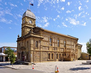
The City of Albany is a local government area in the Great Southern region of Western Australia, about 410 kilometres (255 mi) south-southeast of Perth, the capital of Western Australia. It covers an area of 4,312.3 square kilometres (1,665 sq mi), including the Greater Albany metropolitan area and the Port of Albany, as well as the surrounding agricultural district and some national parks. The City of Albany had a population of over 36,000 at the 2016 census.
Palmdale is an incorporated city in Los Angeles County and California's 2nd largest desert city, after Lancaster, California.
Lower Mangrove is a suburb of the Central Coast region of New South Wales, Australia, located about 8 kilometres (5 mi) upstream and north of Spencer along Mangrove Creek. It is part of the Central Coast Council local government area.
Durren Durren is a suburb of the Central Coast region of New South Wales, Australia. It is part of the Central Coast Council local government area.
Palm Grove is a suburb of the Central Coast region of New South Wales, Australia. It is located about 10 kilometres (6 mi) upstream along Ourimbah Creek from the town of Ourimbah. It is part of the Central Coast Council local government area.
Halloran is a sparsely populated suburb of the Central Coast region of New South Wales, Australia, located off the Sydney-Newcastle Freeway between Wyong and Morisset. It is part of the Central Coast Council local government area.
Crangan Bay is a coastal suburb of the Central Coast region of New South Wales, Australia, located between Budgewoi and Swansea on the bay of the same name. It is part of the Central Coast Council local government area.
Moonee is a coastal suburb of the Central Coast region of New South Wales, Australia. It is part of the Central Coast Council local government area.


