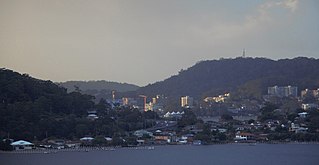
Gosford is a waterfront city on the northern extremity of Brisbane Water in the Central Coast Council local government area in the heart of the Central Coast in New South Wales, Australia. Gosford is known for sailing and boating as well as scenic views on the foreshore of Brisbane Water and the surrounding valleys. It is situated 77 km (48 mi) north of Sydney and 86 km (53 mi) south of Newcastle. Gosford is the administrative and commercial centre as well as the gateway of the Central Coast.

The City of Gosford was a local government area that was located in the Central Coast region in the state of New South Wales, Australia. The incorporation of Gosford dates back to 1886 when the Town of Gosford was proclaimed as the Borough of Gosford, becoming the Municipality of Gosford from 1906. In 1908, the Gosford Municipality merged into Erina Shire which covered the remaining Central Coast area outside of Gosford, but regained its independence in 1936. From 1 January 1947, local government in the Central Coast region was reorganised, creating Gosford Shire and Wyong Shire, and the final boundaries of Gosford City Council date from this period. From 1 January 1980, Gosford Shire was granted city status, becoming the City of Gosford. On 12 May 2016 the Minister for Local Government amalgamated the City of Gosford and Wyong Shire Councils. The Central Coast Council was established on the same day, covering the combined areas.

Wyong Shire was a local government area located in the Central Coast region of New South Wales, Australia. The incorporation of the Wyong area dates back to 7 March 1906 when the entire area of the Brisbane Water Police District outside of the Town of Gosford was proclaimed as the Erina Shire. From 1 January 1947, local government in the Central Coast region was reorganised, creating Gosford Shire and Wyong Shire, which comprised Erina Shire north and east of Kulnura, Central Mangrove and Lisarow.

Kincumber is a south-eastern suburb of the Central Coast region of New South Wales, Australia, nested between the Kincumba Mountain Reserve and the Kincumber Broadwater and located 87 kilometres (54 mi) north of Sydney via the Sydney-Newcastle Freeway (F3). It is part of the Central Coast Council local government area. It is on The Guringgai land

Copacabana is a suburb located on the Central Coast of New South Wales, Australia, as part of the Central Coast Council local government area. Copacabana is situated at the northern end of Macmasters Beach, the two beaches divided by Cochrone Lagoon. The northern headland of Copacabana beach is Tudibaring Point, purported to mean 'place where the waves pound like a beating heart' in the local indigenous language. The bay itself is Allagai, which means "nest of snakes" in the same language.

Erina is a suburb located in the Central Coast region of New South Wales, Australia between Gosford and the Pacific Ocean at Terrigal. It is part of the Central Coast Council local government area.

Wyoming is a suburb of the Central Coast region of New South Wales, Australia, located 4 kilometres (2 mi) northeast of Gosford's central business district. It is part of the Central Coast Council local government area.

Wamberal is a coastal suburb of the Central Coast region of New South Wales, Australia, just north of Terrigal. It is part of the Central Coast Council local government area and is located adjacent to the Wamberal Lagoon. Wamberal is an Aboriginal word meaning 'where the sea breaks'.

Avoca Beach is a coastal suburb of the Central Coast region of New South Wales, Australia, about 95 kilometres (59 mi) north of Sydney. Avoca Beach is primarily a residential suburb, Avoca Beach is also a popular tourist destination. Avoca Beach is known for its surfing and state (regional) surf competitions. Avoca Beach village has a variety of restaurants and cafes as well as a post office, newsagent, pharmacy and mini-mart. Avoca Beach also has a historic cinema, a hotel, bowling club, motel and caravan park. It is located within the Central Coast Council local government area.

Davistown is a south-eastern suburb of the Central Coast region of New South Wales, Australia. It is part of the Central Coast Council local government area.

East Gosford is a suburb of the Central Coast region of New South Wales, Australia, located immediately south-east of Gosford's town centre. It is part of the Central Coast Council local government area, and occupies an area previously inhabited by the Guringai (Wanangine) People. East Gosford is named after the Archibald Acheson, 2nd Earl of Gosford, with whom New South Wales Governor George Gipps served in Canada. Archibald Acheson was appointed Governor of British North America in 1835, and conducted a royal commission into the state of affairs in Lower Canada.
Erina Heights is a suburb of the Central Coast region of New South Wales, Australia between Gosford and the Pacific Ocean at Terrigal. It is part of the Central Coast Council local government area.

Ettalong Beach is a suburb of the Central Coast region of New South Wales, Australia south of Woy Woy on Brisbane Water at the point where it meets Broken Bay, about 86 km north of Sydney. It is part of the Central Coast Council local government area. Ettalong Beach is the natural eastward continuation of Umina Beach and Ocean Beach. The village is serviced by a small retail centre along Ocean View Road.
Glenworth Valley is a suburb of the Central Coast Council local government area in the Central Coast region of New South Wales, Australia. About 73 km (45 mi) north of Sydney and 20 km (12 mi) west of Gosford, at the 2016 census it had a population of 10 people. Popran Creek runs through the entire valley and rises in the locality of Central Mangrove and then flows for approximately 24 km (15 mi) in a mostly southern direction until it reaches Mangrove Creek.

Kariong is a locality of the Central Coast region of New South Wales, Australia west of Gosford along the Central Coast Highway. It is part of the Central Coast Council local government area.

Pearl Beach is a suburb of Central Coast Council on the Central Coast of New South Wales, Australia. Pearl Beach was assigned 'suburb' status by the Geographical Names Board of NSW on 25 October 1991.

St Huberts Island is a canal estate and suburb of the Central Coast region of New South Wales, Australia connected to the mainland at Daleys Point. It is part of the Central Coast Council local government area.

Tascott is a suburb of the Central Coast region of New South Wales, Australia between Gosford and Woy Woy on Brisbane Water's western shore. It is part of the Central Coast Council local government area.

West Gosford is a suburb of the Central Coast region of New South Wales, Australia. It is part of the Central Coast Council local government area. West Gosford is home to the Henry Kendall cottage and was home to the Gosford Classic Car Museum prior to its 2019 closure. While there is some residential areas, West Gosford is known as a retail and industry hub. Bunnings, Spotlight, Anaconda and Officeworks join the Gosford RSL and a Reliance Super Clinic along the Central Coast Highway.

The Central Coast Council is a local government area in the Central Coast region of New South Wales, Australia. The area is adjacent to the Pacific Highway, Central Coast Highway and the Northern NSW railway line as well as the Pacific Ocean. The council has over 40 beaches and over 90km of coastline. The Central Coast Council was formed on 12 May 2016 following the merger of the Gosford City and Wyong Shire councils.


