Ku-ring-gai Chase National Park is a national park on the northern side of Sydney in New South Wales, Australia. The 14,977-hectare (37,010-acre) park is 25 kilometres (16 mi) north of the Sydney Central Business District and generally comprises the land east of the Sydney-Newcastle Expressway, south of the Hawkesbury River, west of Pittwater and north of Mona Vale Road. It includes Barrenjoey Headland on the eastern side of Pittwater.

The Wyrrabalong National Park is a protected national park that is located on the Central Coast of New South Wales, in eastern Australia. The 620-hectare (1,500-acre) national park consists of two main sections; the northern section consists of approximately 480 hectares and covers a substantial area of the peninsula between The Entrance and Norah Head as well as Terilbah and Pelican Islands within Tuggerah Lake. The southern section consists of about 120 hectares of the coast, from Shelly Beach south to Forresters Beach. The park is also noted for containing the last significant coastal (littoral) rainforest on the Central Coast.

Wyong Shire was a local government area located in the Central Coast region of New South Wales, Australia, north of Sydney.

Glenrock Lagoon, an intermediate freshwater small coastal creek, is located within the Lake Macquarie local government area in the Newcastle and Hunter regions of New South Wales, Australia. The lake is located near the Newcastle suburbs of Adamstown and Dudley and is situated about 153 kilometres (95 mi) north of Sydney.

The Entrance is a district centre and town in the Central Coast region of New South Wales, Australia. It is part of the Central Coast Council local government area. At the 2011 census, The Entrance had a population of 3,873 people.

The Awabakal people, a group of indigenous people of New South Wales, are those Aboriginal Australians who identify with or are descended from the Awabakal tribe and its clans scattered along the coastal area of what is now known as the Mid North Coast region of New South Wales. Their traditional territory spread from Wollombi in the south, to the Lower Hunter River near Newcastle and Lake Macquarie in the north.

Kuringgai is an ethnonym referring to (a) an hypothesis regarding an aggregation of indigenous Australian peoples occupying the territory between the southern borders of the Gamilaraay and the area around Sydney (b) perhaps an historical people with its own distinctive language, located in part of that territory, or (c) people of aboriginal origin who identify themselves as descending from the original peoples denoted by (a) or (b) and who call themselves Guringai.

Lake Munmorah or Munmorah Lake, a lagoon that is part of the Tuggerah Lakes, is located within the Central Coast Council local government area in the Central Coast region of New South Wales, Australia. The lake is located near the settlement of Lake Munmorah and is situated about 110 kilometres (68 mi) north of Sydney.

Lake Macquarie or Awaba is Australia's largest coastal salt water lagoon. Located in the Hunter Region of New South Wales, it covers an area of 110 square kilometres (42.5 sq mi) and is connected to the Tasman Sea by a short channel. Most of the residents of the City of Lake Macquarie live near the shores of the lake.
Gorokan is a suburb of the Central Coast region of New South Wales, Australia. It is part of the Central Coast Council local government area. The word "Gorokan" means "The Morning Dawn" from the language of the Awabakal. There are two schools in the area, Gorokan Public and Gorokan High School. Electricity was first brought to the area as a part of a £42,000 programme for electricity reticulation under the Brisbane Water County Council. Gorokan located on the shores of Lake Tuggerah has long been a holiday destination with the Quoy family first buying land in the area in 1923 where they built and rented a series of holiday homes. Other families such as the Gedlings built a holiday house on the Gorokan waterfront in 1956.
Charmhaven is a suburb of the Central Coast region of New South Wales, Australia. It is part of the Central Coast Council local government area.
Lake Munmorah is a suburb of the Central Coast region of New South Wales, Australia. It is part of the Central Coast Council local government area.

Two Peoples Bay Nature Reserve is a protected area managed by the Department of Parks and Wildlife 35 kilometres (22 mi) east of Albany, Western Australia. The area is accessible by 2WD vehicles. The bay itself, including two small secluded beaches, faces due east and is protected from the Southern Ocean by a headland formed by the granite massif of Mount Gardiner. The nature reserve was established in 1967 to protect the threatened noisy scrub-bird and its habitat.

The Budgewoi Lake, a lagoon that is part of the Tuggerah Lakes, is located within the Central Coast Council local government area in the Central Coast region of New South Wales, Australia. The lake is located near the settlement of Budgewoi and is situated about 100 kilometres (62 mi) north of Sydney.

The Boorganna Nature Reserve is a protected nature reserve located northwest of Taree on the Comboyne Plateau in New South Wales, Australia. The 396-hectare (980-acre) reserve, managed by the NSW National Parks & Wildlife Service, was gazetted in 1904 and is the second oldest nature reserve in the state. The reserve features various forest types, including stands of sub tropical rainforest of which the large rosewood, yellow carabeen and small leaf fig are particularly noteworthy. The reserve is a remnant of the former extensive rainforest on the Comboyne Plateau. The plateau was cleared between 1900 and 1925. Australian red cedar was logged in the area in the nineteenth century. Originally proposed to be part of the world heritage rainforest group. The exploration, knowledge, uses and history of this area by Indigenous Australians is not well known in the present day.

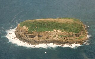
The Bird Island Nature Reserve is a protected nature reserve located near Lake Munmorah on the Central Coast region of New South Wales, Australia. The island is situated 1.4 kilometres (0.87 mi) off the east coast of New South Wales, within the Tasman Sea. The reserve may be seen from the lighthouse at Norah Head.

The 2013 New South Wales bushfires were a series of bushfires in Australia across the state of New South Wales primarily starting, or becoming notable, on 13 October 2013; followed by the worst of the fires beginning in the Greater Blue Mountains Area on 16 and 17 October 2013.


