
The Brisbane Water National Park is a protected national park that is located in the Central Coast region of New South Wales, in eastern Australia. The 11,506-hectare (28,430-acre) national park is situated 47 kilometres (29 mi) north of Sydney, 10 kilometres (6.2 mi) west of Woy Woy, and 12 kilometres (7.5 mi) southwest of Gosford.
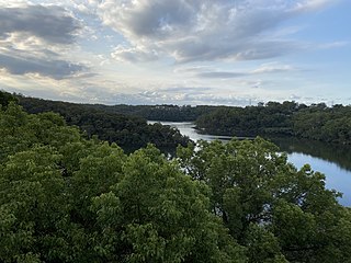
Georges River National Park is a protected Australian National Park, under the management of the NSW National Parks and Wildlife Service. The park falls in the regions of the Sutherland Shire Council and Bankstown City Council. Located in the city of Sydney, 25 km south-west of the CBD, surrounded by neighbouring suburbs of Lugano, Illawong, Alfords Point, Padstow Heights, Revesby Heights, Picnic Point and Sandy Point. The primary use of the park is to service for recreational activities such as; bush walking, picnics, barbeques, boating, fishing, and water/jet skiing. The park is Segmented into 15 sectors along the riverbanks of the Georges River, encompassing 514 hectares (1,270-acres), housing many native aquatic and terrestrial Australian flora and fauna. The traditional custodians are the Dharug people located on the north side of the river, and Dharawal people located on the south of the river.

The Yengo National Park is a protected national park that is located in the Lower Hunter region of New South Wales, in eastern Australia. The 154,328-hectare (381,350-acre) park is situated 85 kilometres (53 mi) northwest of the Sydney central business district, 40 kilometres (25 mi) south of Cessnock, 40 kilometres (25 mi) north of Wisemans Ferry, and 155 kilometres (96 mi) southwest of Newcastle.

The Department of Environment and Conservation (DEC) was a department of the Government of Western Australia that was responsible for implementing the state's conservation and environment legislation and regulations. It was formed on 1 July 2006 by the amalgamation of the Department of Environment and the Department of Conservation and Land Management.

Hacks Lagoon Conservation Park is a protected area in the Australian state of South Australia located in the locality of Bool Lagoon about 24 kilometres south of the municipal seat of Naracoorte.

Spring Gully Conservation Park, formerly the Spring Gully National Park), is a protected area located in the Australian state of South Australia in the localities of Sevenhills and Spring Gully about 6 kilometres (3.7 mi) south of the town centre in Clare.
The New South Wales Office of Environment and Heritage (OEH), a former division of the Government of New South Wales between April 2011 and July 2019, was responsible for the care and protection of the environment and heritage, which includes the natural environment, Aboriginal country, culture and heritage, and built heritage in New South Wales, Australia. Until its abolition in 2019, the OEH supported the community, business and government in protecting, strengthening and making the most of a healthy environment and economy within the state. The OEH was part of the Department of Planning and Environment cluster and managed national parks and reserves.

Seal Bay Conservation Park is a protected area located on the south coast of Kangaroo Island in the Australian state of South Australia. It is the home of the third largest Australian sea lion colony in Australia.
The South West Slopes is a region predominantly in New South Wales, Australia. It covers the lower inland slopes of the Great Dividing Range extending from north of Cowra through southern NSW into western Victoria. More than 90% of the region is in the state of New South Wales and it occupies about 10% of that state.

The Paroo-Darling National Park is a protected national park that is located in the Far West region of New South Wales, in eastern Australia. The 178,053-hectare (439,980-acre) national park spans two distinct regions in the outback area. This region covers the arid catchments of the Paroo River and the Paroo-Darling confluence to the south.

The Yanga National Park is a newly formed national park, located near the township of Balranald in south- western New South Wales. It covers an area of 66,734 hectares which includes 1,932 hectares of Yanga Nature Reserve, and has a frontage of 170 kilometres (110 mi) on the Murrumbidgee River. It is largely located in the Lower Murrumbidgee Floodplain, which is included on A Directory of Important Wetlands in Australia because of its importance as a breeding site for waterbirds when flooded.

The Yathong Nature Reserve is a protected nature reserve that is also a nationally and internationally recognized biosphere situated in the central-western region of New South Wales, in eastern Australia. The 107,240-hectare (265,000-acre) reserve was listed by UNESCO in 1977 as a Biosphere Reserve under the Man and the Biosphere Programme (MAB). The reserve is significant for its biodiversity in both native plant and animal species. Cultural heritage and historical grazing activities add to the significance of this site as a conservation area.
Nuyts Archipelago Conservation Park is a protected area in the Australian state of South Australia located on Eyre Island and St Peter Island in the Nuyts Archipelago located off the west coast of Eyre Peninsula about 10 kilometres south and 25 kilometres south-east respectively of Ceduna.

Peebinga Conservation Park is a 34 km2 protected area lying 40 km north of the town of Pinnaroo in the Murray Mallee region of south-eastern South Australia, about 240 km east of Adelaide and 10 km west of the Victorian border.
The Queanbeyan Nature Reserve is a protected nature reserve that is located in the Southern Tablelands region of New South Wales, in eastern Australia. The 67-hectare (170-acre) reserve is situated approximately 4 kilometres (2.5 mi) west-south-west of the City of Queanbeyan.

The Charcoal Tank Nature Reserve is a protected nature reserve in the central western region of New South Wales, Australia. The 86.4-hectare (213-acre) reserve is situated 10 kilometres (6.2 mi) south of West Wyalong and may be accessed via the Newell Highway and The Charcoal Tank Road. The reserve is an important refuge for native flora and fauna in a highly fragmented landscape, one in which the majority of the original vegetation has been removed.
Olive Island Conservation Park is a protected area in the Australian state of South Australia associated with Olive Island off the west coast of Eyre Peninsula and which is located about 25 kilometres west-northwest of the town of Streaky Bay.

Hartley historic site is a heritage-listed historic village located adjacent to the Great Western Highway, Hartley, City of Lithgow, New South Wales, Australia. It was built from 1837 to 1850. It is also known as Hartley Historic Site and Hartley Township. The property is owned and protected by Office of Environment and Heritage, an agency of the Government of New South Wales. It was added to the New South Wales State Heritage Register on 2 April 1999.

The Caloola Club was a bushwalking and outdoors activity club that was based in Sydney, New South Wales, Australia, founded in 1945 and active until 1963 when it merged with the National Parks Association of N.S.W. The club was an influential part of the 'second wave' of the conservation and environmental movement in New South Wales during the post-WWII period.

Limeburners Creek National Park is a protected national park on the Mid North Coast of New South Wales, Australia. The 91.2 km national park is located 5 km (3.1 mi) to the north of Port Macquarie and exists across both the Kempsey Shire and Port Macquarie-Hastings Council local government areas, but is chiefly managed by National Parks and Wildlife Service. The area was originally erected as a nature reserve but this reservation was revoked when it became formally recognised as a national park in 2010 under the National Parks and Wildlife Act (1974). Many threatened ecological habitats and species of fauna and flora are found within this park, alongside several heritage sites of cultural significance, particularly to the local Birpai and Dunghutti people upon whose land the park exists. The protected status of this national park is largely owing to the ecological and cultural value of the area, in addition to the value of the ecosystems to further scientific research.
 Park ranger vehicle used for various purposes including patrols, conservation efforts and firefighting assistance
 Cessna 208 used for duties such as mapping, firefighting and more long distance transport
