
The Central Coast is a peri-urban region lying on the Pacific Ocean in northern-eastern New South Wales, Australia. The region is situated north of Sydney, which is filled with subtropical national parks, forests and also encompasses the major coastal waterways of Brisbane Water, Tuggerah Lakes and southern Lake Macquarie. The region's hinterland, which has fertile valleys, rural farmland and wineries, and also includes the Watagan Mountains. The Central Coast is known for its regional coastal towns like Terrigal, The Entrance, Ettalong Beach, Budgewoi and Bateau Bay with resorts and holiday parks, which feature many expansive beaches and lagoons with surfing and coastal tracks, as well as scenic views. Gosford is the main commercial hub and gateway.

Tuggerah Lake, an intermittently open intermediate wave dominated barrier estuary that is part of the Tuggerah Lakes, is located within the Central Coast Council local government area in the Central Coast region of New South Wales, Australia. The lake is located near Wyong and is situated about 90 kilometres (56 mi) north of Sydney.

Wyong Shire was a local government area located in the Central Coast region of New South Wales, Australia. The incorporation of the Wyong area dates back to 7 March 1906 when the entire area of the Brisbane Water Police District outside of the Town of Gosford was proclaimed as the Erina Shire. From 1 January 1947, local government in the Central Coast region was reorganised, creating Gosford Shire and Wyong Shire, which comprised Erina Shire north and east of Kulnura, Central Mangrove and Lisarow.

Lake Ellesmere / Te Waihora is a broad, shallow coastal lake or waituna, in the Canterbury region of the South Island of New Zealand. It is directly to the west of Banks Peninsula, separated from the Pacific Ocean by the long, narrow, sandy Kaitorete Spit, or more correctly Kaitorete Barrier. It lies partially in extreme southeastern Selwyn District and partially in the southwestern extension of the former Banks Peninsula District, which now is a ward in the city of Christchurch. The lake holds high historical and cultural significance to the indigenous Māori population and the traditional Māori name Te Waihora, means spreading waters. It has officially had a dual English/Māori name since at least 1938.
Toukley is a town in the Central Coast region of the Australian state of New South Wales and is located within Central Coast Council. It lies approximately 109 km north of Sydney and 54 km south of Newcastle via the Pacific Motorway (M1). It is located between Tuggerah Lake, Budgewoi Lake, and the Pacific Ocean. At the channel connecting Tuggerah Lake and Budgewoi Lake the new Toukley bridge was constructed between 1983 and 1985 linking Toukley on the eastern side of the Lakes system with Gorokan on the west, replacing the old two lane wooden bridge.

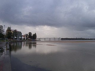
The Entrance is a coastal town in the Central Coast region of New South Wales, Australia. It is part of the Central Coast Council local government area. At the 2021 census, The Entrance had a population of 4,244 people.

Wyong railway station is a heritage-listed railway station located on the Main Northern line in New South Wales, Australia. It serves the northern Central Coast town of Wyong.

Kanwal is a suburb just west of the Tuggerah Lake on the Central Coast, New South Wales, Australia. It is part of the Central Coast Council local government area and is approximately nine kilometres north east of Wyong and six kilometres west of the Pacific Ocean.
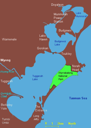
Lake Munmorah or Munmorah Lake, a lagoon that is part of the Tuggerah Lakes, is located within the Central Coast Council local government area in the Central Coast region of New South Wales, Australia. The lake is located near the settlement of Lake Munmorah and is situated about 110 kilometres (68 mi) north of Sydney.

Lake Macquarie is Australia's largest coastal lagoon. Located in the City of Lake Macquarie and Central Coast Council local government areas in the Hunter and Central Coast regions of New South Wales, Australia, it covers an area of 110 square kilometres (42.5 sq mi) and is connected to the Tasman Sea by a short channel. Most of the residents of the City of Lake Macquarie live near the shores of the lagoon.
The Entrance Bridge is a road bridge that carries the Central Coast Highway (A49) across the Tuggerah Lakes Entrance Channel and joins the towns of The Entrance and The Entrance North, located on the Central Coast of New South Wales, Australia. The 18-span, 467-metre long (1,532 ft) concrete girder bridge carries road traffic, as well as a grade-separated pedestrian footpath and cycleway, across Wilfred Barrett Drive as part of the Central Coast Highway.

Budgewoi is a coastal town that is located on the Central Coast of New South Wales, Australia. Budgewoi is situated on two peninsulas that is split by the Budgewoi Lake. The town is located about 114 km northeast of Sydney. It is part of the Central Coast Council local government area.
The Entrance North is a coastal village in The Entrance District of the Central Coast region of New South Wales, Australia. It is at the end of a peninsula with Tuggerah Lake to the west and the Tasman Sea to the east. To the south is The Entrance Channel in which flows Tuggerah Lake and on the southern shore is The Entrance. Crossing the channel by foot or road is via The Entrance Bridge. It is part of the Central Coast Council local government area.
The Central Coast Division of Country Rugby League is a rugby league competition based on the Central Coast of New South Wales between Sydney and Newcastle. The competition was founded in 1947 as a junior competition for the Newcastle club, Lakes United. The competition rapidly expanded and grew, so much so that in 1967, it was upgraded to full membership of the Country Rugby League as Group 12. In 1981, it was upgraded and renamed Central Coast Division. The division covers the entire region of the Central Coast from Woy Woy and Umina in the south up to Budgewoi and Gwandalan in the north.
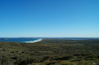
Munmorah State Conservation Area is located on the Central Coast of New South Wales, Australia. The area's coastal setting and panoramic views, perched sand dunes, diverse vegetation communities, protected threatened species and migratory bird habitats, together with opportunities for nature based recreation and for educational and scientific study, were cited as reasons for the reserve's creation. The reserve is part of the Tuggerah Important Bird Area, identified as such by BirdLife International because of its importance for a variety of water and woodland birds.
The Budgewoi Lake is a lagoon that is part of the Tuggerah Lakes, that is located within the Central Coast Council local government area in the Central Coast region of New South Wales, Australia. The lake is located near the settlement of Budgewoi and is situated about 100 kilometres (62 mi) north of Sydney.

The Wyong River is a perennial river that is located in the Central Coast region of New South Wales, Australia.

Murtnaghurt Lagoon, also known as Murtnaghurt Swamp or Lake Murtnaghurt, is a shallow, ephemeral wetland west of the town of Barwon Heads on the southern coast of the Bellarine Peninsula in Victoria, Australia. It comprises two enclosed depressions, elongated west-east and separated by a low ridge. The wetland is about 2 kilometres (1.2 mi) in length, and up to 600 metres (2,000 ft) wide, with 4.5 kilometres (2.8 mi) of shoreline enclosing an area of 81 hectares. It is connected by a narrow 2.7 kilometres (1.7 mi) palaeochannel extending from the lagoon northwards to the main tidal channel of the lower Barwon River.
This article provides information on the under-16 premiership deciders of rugby league competitions held on the Central Coast of New South Wales, Australia. The match details sub-section details the individual point-scorers in a match, where known. In 1996 and all but one season since 2003, a second tier under-16 competition has also been held.


