The Bouddi National Park is a coastal national park that is located in the Central Coast region of New South Wales, in eastern Australia. The 1,532-hectare (3,790-acre) national park is situated 93 kilometres (58 mi) northeast of Sydney. A section of the national park extends into the Tasman Sea, creating fully protected land, shore and marine habitats. The park contains one of the last mature temperate rainforests on the Central Coast, Fletchers Glen.

Hat Head is a national park on the Mid North Coast of New South Wales, Australia, 461.7 kilometres (286.9 mi) north-east of Sydney. It lies within the Hastings-Macleay Important Bird Area. Within the park is the eponymous village of Hat Head, with about 320 inhabitants.

Myall Lakes National Park is a national park located in New South Wales, Australia, 236 kilometres (147 mi) north of Sydney. It encompasses one of the state's largest coastal lake systems Myall Lakes, and includes Broughton Island. The park includes 40 kilometres of beaches and rolling sand dunes. Myall Lakes is also one of the most visited parks in New South Wales.

Popran National Park is a protected national park that is located west of the M1 Pacific Motorway in the Central Coast region of New South Wales, in eastern Australia. The 3,970-hectare (9,800-acre) park is situated 95 kilometres (59 mi) north of Sydney. The Park takes its name from Popran Creek which rises in the locality of Central Mangrove and then flows for approximately 24 km in a mostly southern direction until it reaches Mangrove Creek. Popran Creek flows through the Glenworth Valley, also known as the Popran Valley. The average elevation of the terrain is 135 metres.

The Washpool National Park is a protected national park located in the New England region of New South Wales, Australia. The 58,678-hectare (145,000-acre) park is situated approximately 520 kilometres (320 mi) north of Sydney, inland from Grafton. The park has two campgrounds and is managed by the NSW National Parks & Wildlife Service. It was established in 1983 to preserve the significant plant and animal populations found in the Washpool and Gibraltar Range forests. In 1999 the park was expanded to include areas that had previously been threatened with logging, which a court injunction put to a stop to in 1990.
Woko is a national park in New South Wales, Australia, 243 km north of Sydney.

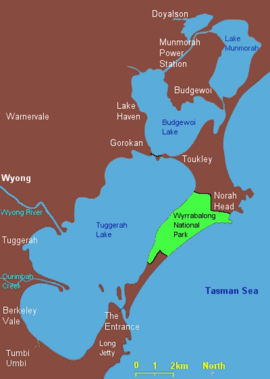
Tuggerah Lake, an intermittently open intermediate wave dominated barrier estuary that is part of the Tuggerah Lakes, is located within the Central Coast Council local government area in the Central Coast region of New South Wales, Australia. The lake is located near Wyong and is situated about 90 kilometres (56 mi) north of Sydney.

Myall Lakes, a series of fresh water lakes protected under the Ramsar Convention, are located within the Mid-Coast Council local government area in the Mid North Coast region of New South Wales, Australia.
The Darkinjung are the Local Aboriginal Land Council in the Central Coast, New South Wales, participating in formal joint management of some areas of state forest in the region. It represents over 450 local Aboriginal residents. The Darkinjung Local Aboriginal Land Council are caretakers of the Central Coast of NSW Australia.

The Awabakal people, are those Aboriginal Australians who identify with or are descended from the Awabakal tribe and its clans, Indigenous to the coastal area of what is now known as the Hunter Region of New South Wales. Their traditional territory spread from Wollombi in the west, to the Lower Hunter River near Newcastle and Lake Macquarie in the north.
Kuringgai is an ethnonym referring to an Indigenous Australian people who once occupied the territory between the southern borders of the Gamilaraay and the area around Sydney, and an historical people with its own distinctive language, located in part of that territory.
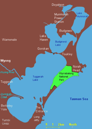
Lake Munmorah or Munmorah Lake, a lagoon that is part of the Tuggerah Lakes, is located within the Central Coast Council local government area in the Central Coast region of New South Wales, Australia. The lake is located near the settlement of Lake Munmorah and is situated about 110 kilometres (68 mi) north of Sydney.

Lake Macquarie is Australia's largest coastal lagoon. Located in the City of Lake Macquarie and Central Coast Council local government areas in the Hunter and Central Coast regions of New South Wales, Australia, it covers an area of 110 square kilometres (42.5 sq mi) and is connected to the Tasman Sea by a short channel. Most of the residents of the City of Lake Macquarie live near the shores of the lagoon.
The Tuggerah Lakes, a wetland system of three interconnected coastal lagoons, are located on the Central Coast of New South Wales, Australia and comprise Lake Munmorah, Budgewoi Lake and Tuggerah Lake.

Forresters Beach is a coastal suburb of the Central Coast region of New South Wales, Australia between Terrigal and Bateau Bay. It forms part of the Central Coast Council local government area. Forresters Beach's reef breaks are well known to surfers. Its name comes from Robert Forrester who purchased 50 acres (200,000 m2) of land in 1861.
Munmorah State Conservation Area is located on the Central Coast of New South Wales, Australia. The area's coastal setting and panoramic views, perched sand dunes, diverse vegetation communities, protected threatened species and migratory bird habitats, together with opportunities for nature based recreation and for educational and scientific study, were cited as reasons for the reserve's creation. The reserve is part of the Tuggerah Important Bird Area, identified as such by BirdLife International because of its importance for a variety of water and woodland birds.

Mount Yengo is a mountain that is located in the Lower Hunter region of New South Wales, in eastern Australia. The 668-metre (2,192 ft) mountain is part of the Calore Range, part of the Great Dividing Range, and is situated within the Yengo National Park, approximately 3 kilometres (1.9 mi) east of the Macdonald River and 17 kilometres (11 mi) east by south of Putty.
The Budgewoi Lake is a lagoon that is part of the Tuggerah Lakes, that is located within the Central Coast Council local government area in the Central Coast region of New South Wales, Australia. The lake is located near the settlement of Budgewoi and is situated about 100 kilometres (62 mi) north of Sydney.

The Werakata National Park is a protected national park that is located in the Lower Hunter Region of New South Wales, in eastern Australia. The 3,337-hectare (8,250-acre) national park is located to the north, east and south of the town of Cessnock.
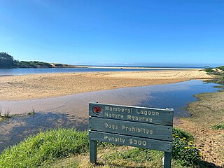
Wamberal Lagoon, an intermittently closed intermediate saline coastal lagoon, is located on the Central Coast region of New South Wales, Australia. Wamberal Lagoon is located between the beachside settlements of Forresters Beach and Wamberal, and adjacent to the Pacific Ocean, about 87 kilometres (54 mi) north of Sydney.