Tooloom National Park New South Wales | |
---|---|
IUCN category II (national park) | |
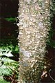
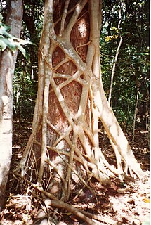
Giant White Beech at Tooloom Scrub | |
Nearest town or city | Urbenville |
Coordinates | 28°26′47″S152°27′13″E / 28.44639°S 152.45361°E Coordinates: 28°26′47″S152°27′13″E / 28.44639°S 152.45361°E |
Established | 22 December 1995 [1] |
Area | 43.80 km2 (16.9 sq mi) [1] |
Managing authorities | NSW National Parks & Wildlife Service |
Website | Tooloom National Park |
See also | Protected areas of New South Wales |
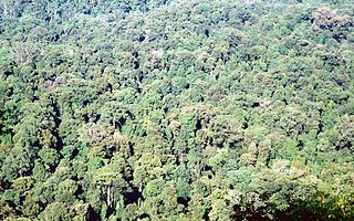
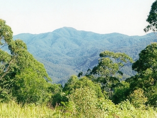
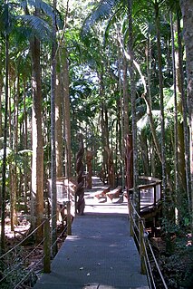
The Tooloom National Park is a protected national park located in the Northern Rivers region of New South Wales, Australia. The 4,380-hectare (10,800-acre) part is situated approximately 616 kilometres (383 mi) north of Sydney and 20 kilometres (12 mi) from the border town of Urbenville.
State parks are parks or other protected areas managed at the sub-national level within those nations which use "state" as a political subdivision. State parks are typically established by a state to preserve a location on account of its natural beauty, historic interest, or recreational potential. There are state parks under the administration of the government of each U.S. state, some of the Mexican states, and in Brazil. The term is also used in the Australian state of Victoria. The equivalent term used in Canada, Argentina, South Africa and Belgium, is provincial park. Similar systems of local government maintained parks exist in other countries, but the terminology varies.
A national park is a park in use for conservation purposes. Often it is a reserve of natural, semi-natural, or developed land that a sovereign state declares or owns. Although individual nations designate their own national parks differently, there is a common idea: the conservation of 'wild nature' for posterity and as a symbol of national pride. An international organization, the International Union for Conservation of Nature (IUCN), and its World Commission on Protected Areas (WCPA), has defined "National Park" as its Category II type of protected areas.
Northern Rivers is the most north-easterly region of the Australian state of New South Wales, located between 590 kilometres (370 mi) and 820 kilometres (510 mi) north of the state capital, Sydney, and encompasses the catchments and fertile valleys of the Clarence, Richmond and Tweed rivers. It extends from Tweed Heads in the north to the southern extent of the Clarence river catchment which lies between Grafton and Coffs Harbour, and includes the main towns of Tweed Heads, Byron Bay, Ballina, Kyogle, Lismore, Casino and Grafton. At its most northern point, the region is 102 kilometres (63 mi) south south–east of the Queensland capital, Brisbane.
The park is part of the Focal Peak Group World Heritage Site Gondwana Rainforests of Australia inscribed in 1986 [2] and added to the Australian National Heritage List in 2007. [3]
A World Heritage Site is a landmark or area which is selected by the United Nations Educational, Scientific and Cultural Organization (UNESCO) as having cultural, historical, scientific or other form of significance, and is legally protected by international treaties. The sites are judged important to the collective interests of humanity.
The Australian National Heritage List is a heritage register, a list of national heritage places deemed to be of outstanding heritage significance to Australia. The list includes natural, historic and indigenous places. Once on the National Heritage List the provisions of the Environment Protection and Biodiversity Conservation Act 1999 apply.
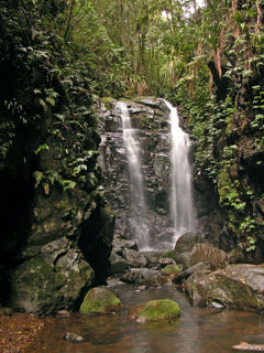
The name Tooloom is derived from Bundjalung word Duluhm meaning headlice, [4] referring to the Tooloom Falls. [5]
The Barrington Tops National Park is a protected national park located in the Hunter Valley, approximately 200 kilometres (120 mi) north of Sydney in New South Wales, Australia. Gazetted in 1969, the 76,512-hectare (189,070-acre) park is situated between Scone, Singleton, Dungog, Gloucester and East Gresford.
The Border Ranges National Park is a protected national park that is located in the Northern Rivers region of New South Wales, Australia. A small portion of the national park is also located in South East Queensland. The 31,729-hectare (78,400-acre) park is situated approximately 150 kilometres (93 mi) south of Brisbane, north of Kyogle.
Gibraltar Range is a national park in north-eastern New South Wales, Australia, 79 kilometres (49 mi) north-east of Glen Innes and 493 kilometres (306 mi) north of Sydney. The Park is part of the Washpool and Gibraltar Range area of the World Heritage Site Gondwana Rainforests of Australia inscribed in 1986 and added to the Australian National Heritage List in 2007.
The Mallanganee National Park is a protected national park located in the Northern Rivers region of New South Wales, Australia. The 1,144-hectare (2,830-acre) park is located approximately 570 kilometres (350 mi) north of Sydney and can be located via Kyogle via the Bruxner Highway and the Summerland Way.
The Mount Clunie National Park is a protected national park that is located in the Northern Rivers region of New South Wales, Australia. The 1,426-hectare (3,520-acre) park is situated approximately 631 kilometres (392 mi) north of Sydney and can be located via Kyogle via the Bruxner Highway and the Summerland Way. The park's north-eastern limits define the state border between New South Wales and Queensland.
The Mount Nothofagus National Park is a protected national park located in the Northern Rivers region of New South Wales, Australia. The 2,180-hectare (5,400-acre) park is located approximately 634 kilometres (394 mi) north of Sydney and can be located via Kyogle via the Bruxner Highway and the Summerland Way.
The Mount Royal National Park is a protected national park located in the Hunter region of New South Wales, Australia. Gazetted in 1997, the 6,920-hectare (17,100-acre) park is situated approximately 187 kilometres (116 mi) north of Sydney.
Wollumbin National Park is a national park located in northern New South Wales, Australia, 642 kilometres (399 mi) north of Sydney near the border with the state of Queensland. It surrounds Mount Warning, part of a remnant caldera of a much larger extinct volcano. The park is administered by the NSW National Parks and Wildlife Service. The park is part of the Scenic Rim Important Bird Area, identified as such by BirdLife International because of its importance in the conservation of several species of threatened birds.
The New England National Park is a protected national park located on the Northern Tablelands in the New England region of New South Wales, Australia. The 67,303-hectare (166,310-acre) park was created in May 1935 and is situated approximately 560 kilometres (350 mi) north of Sydney, and 10 kilometres (6.2 mi) south of Waterfall Way, just 85 kilometres (53 mi) east of Armidale and 65 kilometres (40 mi) west of Coffs Harbour. The closest village to New England National Park is Ebor, located 20 kilometres (12 mi) away.
The Toonumbar National Park is a protected national park located in the Northern Rivers region of New South Wales, Australia. The 14,910-hectare (36,800-acre) park is situated approximately 620 kilometres (390 mi) north of Sydney, near the town of Woodenbong.
The Washpool National Park is a protected national park located in the New England region of New South Wales, Australia. The 58,678-hectare (145,000-acre) park is situated approximately 520 kilometres (320 mi) north of Sydney, inland from Grafton. The park has two campgrounds and is managed by the NSW National Parks & Wildlife Service. It was established in 1983 to preserve the significant plant and animal populations found in the Washpool and Gibraltar Range forests.
The Werrikimbe National Park is a protected national park located in the catchment zone of the Upper Hastings River in New South Wales, Australia. Gazetted in 1975, the 33,309-hectare (82,310-acre) park is situated approximately 486 kilometres (302 mi) north of Sydney and 65 kilometres (40 mi) from Wauchope, and 90 kilometres (56 mi) east of Walcha on the eastern escarpment of the Great Dividing Range.
The Willi Willi National Park is a protected national park located on the North Coast region of New South Wales, Australia. Gazetted in 1996, the 29,870-hectare (73,800-acre) park is situated 325 kilometres (202 mi) northeast of Sydney and 60 kilometres (37 mi) west of Wauchope.
The Gondwana Rainforests of Australia, formerly known as the Central Eastern Rainforest Reserves, are the most extensive area of subtropical rainforest in the world. Collectively, the rainforests are a World Heritage Site with fifty separate reserves totalling 366,500 hectares from Newcastle to Brisbane.
The Mount Hyland Nature Reserve is a protected nature reserve that is located in the New England region of New South Wales, in eastern Australia. The 2,519-hectare (6,220-acre) reserve is situated approximately 35 kilometres (22 mi) west of Dorrigo.
The Fenwicks Scrub Flora Reserve is a protected nature reserve that is located on the Mid North Coast of New South Wales, Australia. The 110-hectare (270-acre) reserve is situated west of Port Macquarie on the Great Dividing Range. The reserve is dominated by warm temperate rainforest. Rainforest occurs between 990 and 1,100 metres above sea level. The 20 metres (66 ft) tall canopy is 98% Sassafras and Coachwood.
The Wilsons Peak Flora Reserve is a protected nature reserve that is located in the Northern Rivers region in the state of New South Wales, in eastern Australia. The reserve is bounded to the north by the border between New South Wales and the state of Queensland. The nearest town is the Queensland settlement of Killarney.
The Iluka Nature Reserve in a protected nature reserve that is located in the Northern Rivers region of New South Wales, Australia. The 135-hectare (330-acre) reserve is situated near the coastal town of Iluka.
The Sea Acres National Park is a national park that is located in the Mid North Coast region of New South Wales, in eastern Australia. The 76-hectare (190-acre) park is situated near the town of Port Macquarie. The park is a popular tourist area with a 1.3-kilometre (0.81 mi) long boardwalk through a remnant of seaside rainforest. There is also an education centre and cafe. The park was initially declared as a nature reserve in 1987; and gazetted as a national park in October 2010.
The Kattang Nature Reserve is a protected nature reserve that is located in the Mid North Coast region of New South Wales, on the eastern coast of Australia. The 68-hectare (170-acre) reserve is situated 7 kilometres (4.3 mi) from Laurieton, 47 kilometres (29 mi) south of Port Macquarie and 10 kilometres (6.2 mi) east of the Pacific Highway, near Kew.
This New South Wales protected areas related article is a stub. You can help Wikipedia by expanding it. |