
The Border Ranges National Park is a protected national park that is located in the Northern Rivers region of New South Wales, Australia. A small portion of the national park is also located in South East Queensland. The 31,729-hectare (78,400-acre) park is situated approximately 150 kilometres (93 mi) south of Brisbane, north of Kyogle.

Gibraltar Range is a national park in north-eastern New South Wales, Australia, 79 kilometres (49 mi) north-east of Glen Innes and 493 kilometres (306 mi) north of Sydney. The Park is part of the Washpool and Gibraltar Range area of the World Heritage Site Gondwana Rainforests of Australia inscribed in 1986 and added to the Australian National Heritage List in 2007.

Koreelah is a national park in New South Wales, Australia, 631 km north of Sydney. The park is part of the Scenic Rim Important Bird Area, identified as such by BirdLife International because of its importance in the conservation of several species of threatened birds.
The Mount Clunie National Park is a protected national park that is located in the Northern Rivers region of New South Wales, Australia. The 1,426-hectare (3,520-acre) park is situated approximately 631 kilometres (392 mi) north of Sydney and can be located via Kyogle via the Bruxner Highway and the Summerland Way. The park's north-eastern limits define the state border between New South Wales and Queensland.
The Mount Nothofagus National Park is a protected national park located in the Northern Rivers region of New South Wales, Australia. The 2,180-hectare (5,400-acre) park is located approximately 634 kilometres (394 mi) north of Sydney and can be located via Kyogle via the Bruxner Highway and the Summerland Way.
Wollumbin National Park is a national park located in northern New South Wales, Australia, 642 kilometres (399 mi) north of Sydney near the border with the state of Queensland. It surrounds Mount Warning, part of a remnant caldera of a much larger extinct volcano. The park is administered by the NSW National Parks and Wildlife Service. The park is part of the Scenic Rim Important Bird Area, identified as such by BirdLife International because of its importance in the conservation of several species of threatened birds.
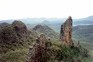
Warrumbungle National Park is a heritage listed national park located in the Orana region of New South Wales, Australia. The national park is located approximately 550 kilometres (340 mi) northwest of Sydney and contained within 23,311 hectares. The park attracts approximately 35,000 visitors per annum.

The Lamington National Park is a national park, lying on the Lamington Plateau of the McPherson Range on the Queensland/New South Wales border in Australia. From Southport on the Gold Coast the park is 85 kilometres (53 mi) to the southwest and Brisbane is 110 kilometres (68 mi) north. The 20,600 hectares Lamington National Park is known for its natural environment, rainforests, birdlife, ancient trees, waterfalls, walking tracks and mountain views.

The Main Range is a mountain range and national park in Queensland, Australia, located predominantly in Tregony, Southern Downs Region, 85 kilometres (53 mi) southwest of Brisbane. It is part of the World Heritage Site Gondwana Rainforests of Australia. It protects the western part of a semicircle of mountains in South East Queensland known as the Scenic Rim. This includes the largest area of rainforest in South East Queensland. The park is part of the Scenic Rim Important Bird Area, identified as such by BirdLife International because of its importance in the conservation of several species of threatened birds.

Moogerah Peaks is a National Park in the Fassifern Valley of South East Queensland, Australia, located approximately 70 km south west of the state capital Brisbane. The 676-hectare park consists of four separate protected areas which surround volcanic peaks and rocky cliffs near Moogerah Dam.
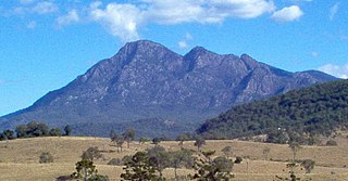
Mount Barney National Park is a national park in Queensland (Australia), 90 km southwest of Brisbane. It amalgamated the adjacent Mount Lindesay National Park in 1980. It is part of the Scenic Rim Important Bird Area, identified as such by BirdLife International because of its importance in the conservation of several species of threatened birds.

Mount Chinghee is a national park in Queensland, Australia, 93 kilometres (58 mi) south of Brisbane. It is part of the Shield Volcano Group of the World Heritage Site Gondwana Rainforests of Australia inscribed in 1986 and added to the Australian National Heritage List in 2007. It is also part of the Scenic Rim Important Bird Area, identified as such by BirdLife International because of its importance in the conservation of several species of threatened birds.

The Springbrook National Park is a protected national park that is located in the Gold Coast hinterland of Queensland, Australia. The 6,197-hectare (15,310-acre) park is situated on the McPherson Range, near Springbrook, approximately 100 kilometres (62 mi) south of Brisbane. The park is part of the Shield Volcano Group of the UNESCO World Heritage–listed Gondwana Rainforests of Australia.
The Limpinwood Nature Reserve is a protected nature reserve that is located on the Northern Rivers region of New South Wales, in eastern Australia. The reserve was gazetted in April 1963 with additions made in 1967, over former fauna and crown reserves, and further additions were made in 1988 to make the reserve to its current area of 2,646 hectares. The reserve is situated north-west of the rural locality of Limpinwood, and north of Tyalgum and defines part of the state border between New South Wales and Queensland.

Tamborine Mountain is a 28 km2 (11 sq mi) plateau and locality in the Scenic Rim local government area of South East Queensland, Australia. In the 2011 census, Tamborine Mountain had a population of 7,030 people. The name is of Aboriginal origin and has nothing to do with the musical instrument. It is considered part of the Gold Coast hinterland and has a strong tourist industry.
The Scenic Rim is a group of forested mountain ranges of the Great Dividing Range straddling the border between south-eastern Queensland and north-eastern New South Wales, Australia.

The eastern bristlebird is a species of bird in the bristlebird family Dasyornithidae. It is endemic to Australia. Its natural habitats are temperate forests, temperate shrubland, and temperate grassland. It is threatened by habitat loss.
Tarcutta Hills Reserve is a 432-hectare (1,070-acre) nature reserve on the lower western slopes of the Great Dividing Range in central west New South Wales, Australia. It is 427 kilometres (265 mi) south-west of Sydney, close to the Hume Highway, and 15 kilometres (9.3 mi) south of Tarcutta. It is owned and managed by Bush Heritage Australia (BHA), which purchased it in 1999, and it is listed on the Register of the National Estate.

Numinbah Nature Reserve is a protected nature reserve that is located in the Northern Rivers region of New South Wales, in eastern Australia. The reserve was gazetted in December 1981 with a further addition made in 1989 to make the reserve to its current area of 858 hectares. The reserve is situated north-east of the rural locality of Numinbah, and south of the Queensland town of Springbrook and defines part of the state border between New South Wales and Queensland.

The Werakata National Park is a protected national park that is located in the Lower Hunter Region of New South Wales, in eastern Australia. The 3,337-hectare (8,250-acre) national park is located to the north, east and south of the town of Cessnock.


