Dooragan National Park

Last updated

Dooragan National Park
New South Wales
IUCN category II (national park)

Hang glider Dorragan NSW.jpg

A hang glider prepared for flight from North Brother Mountain
Australia New South Wales relief location map.png
Red pog.svg
Dooragan National Park
Coordinates 31°39′52″S152°46′26″E / 31.66444°S 152.77389°E / -31.66444; 152.77389 Coordinates: 31°39′52″S152°46′26″E / 31.66444°S 152.77389°E / -31.66444; 152.77389
Established 1997
Area 11 km2 (4.2 sq mi)
Managing authorities National Parks and Wildlife Service (New South Wales)
See also Protected areas of
New South Wales

The Dooragan National Park is a national park on the Mid North Coast of New South Wales, Australia. The national park is situated near Laurieton, and is approximately 365 kilometres (227 mi) northeast of Sydney.

National park park used for conservation purposes of animal life and plants

A national park is a park in use for conservation purposes. Often it is a reserve of natural, semi-natural, or developed land that a sovereign state declares or owns. Although individual nations designate their own national parks differently, there is a common idea: the conservation of 'wild nature' for posterity and as a symbol of national pride. An international organization, the International Union for Conservation of Nature (IUCN), and its World Commission on Protected Areas (WCPA), has defined "National Park" as its Category II type of protected areas.

Mid North Coast Region in New South Wales, Australia

The Mid North Coast is a country region in the north-east of the state of New South Wales, Australia. The region covers the mid to north coast of the state, beginning at Seal Rocks, 275 km (171 mi) north of Sydney, and extending as far north as Woolgoolga, 562 km (349 mi) north of Sydney, a distance of roughly 400 km (250 mi).

New South Wales State of Australia

New South Wales is a state on the east coast of Australia. It borders Queensland to the north, Victoria to the south, and South Australia to the west. Its coast borders the Tasman Sea to the east. The Australian Capital Territory is an enclave within the state. New South Wales' state capital is Sydney, which is also Australia's most populous city. In September 2018, the population of New South Wales was over 8 million, making it Australia's most populous state. Just under two-thirds of the state's population, 5.1 million, live in the Greater Sydney area. Inhabitants of New South Wales are referred to as New South Welshmen.

Contents

Three Brothers

The local aboriginal people tell a dreamtime story of three brothers of the Birpai tribe who were killed by a witch called Widjirriejuggi and were buried where the mountains stand. The youngest of the three was Dooragan, for whom the park is named. [1]

Indigenous Australians are the Aboriginal and Torres Strait Islander people of Australia, descended from groups that existed in Australia and surrounding islands before British colonisation. The time of arrival of the first Indigenous Australians is a matter of debate among researchers. The earliest conclusively human remains found in Australia are those of Mungo Man LM3 and Mungo Lady, which have been dated to around 50,000 years BP. Recent archaeological evidence from the analysis of charcoal and artefacts revealing human use suggests a date as early as 65,000 BP. Luminescence dating has suggested habitation in Arnhem Land as far back as 60,000 years BP. Genetic research has inferred a date of habitation as early as 80,000 years BP. Other estimates have ranged up to 100,000 years and 125,000 years BP.

By amazing coincidence, when Captain James Cook passed the area on 12 May 1770 he named the mountains Three Brothers , since "these Hills bore some resemblance to each other". [2] Cook had earlier (25 January 1769) written of the Three Brothers hills west of Cape St Diego, so perhaps he was inspired by them too.

James Cook 18th-century British explorer

Captain James Cook was a British explorer, navigator, cartographer, and captain in the Royal Navy. He made detailed maps of Newfoundland prior to making three voyages to the Pacific Ocean, during which he achieved the first recorded European contact with the eastern coastline of Australia and the Hawaiian Islands, and the first recorded circumnavigation of New Zealand.

Three Brothers (New South Wales)

Three Brothers, three separate mountains of the Mid North Coast region of New South Wales, Australia, are situated approximately 360 kilometres (220 mi) north of Sydney.

North Brother Mountain (Dooragan) supports a wide range of vegetation communities including some of the best examples of old growth blackbutt forest in the area and pockets of sub-tropical rainforest that provide habitat for gliders, bats and koalas. The park has a weed problem with the spreading of lantana.

<i>Lantana</i> genus of plants

Lantana is a genus of about 150 species of perennial flowering plants in the verbena family, Verbenaceae. They are native to tropical regions of the Americas and Africa but exist as an introduced species in numerous areas, especially in the Australian-Pacific region. The genus includes both herbaceous plants and shrubs growing to 0.5–2 m (1.6–6.6 ft) tall. Their common names are shrub verbenas or lantanas. The generic name originated in Late Latin, where it refers to the unrelated Viburnum lantana.

The mountain was made a timber reserve in 1892 and later called the Camden Haven State Forest. Portions of the mountain were logged but large sections were untouched due to the terrain. It was opened to the public in 1970 when a road to the summit was constructed. [1] The steep windy road has now been sealed, but it is unsuitable for caravans. Viewing platforms, which have wheelchair access, offer good views up and down the coast. Picnic, barbecue and toilet facilities are available. There are walks of varying length and difficulty. [3]

See also

Related Research Articles

Blue Mountains (New South Wales) Region in New South Wales, Australia

The Blue Mountains are a mountainous region and a mountain range located in New South Wales, Australia. The region borders on Sydney's metropolitan area, its foothills starting about 50 kilometres (31 mi) west of centre of the state capital. The public's understanding of the extent of the Blue Mountains is varied, as it forms only part of an extensive mountainous area associated with the Great Dividing Range. Officially the Blue Mountains region is bounded by the Nepean and Hawkesbury rivers in the east, the Coxs River and Lake Burragorang to the west and south, and the Wolgan and Colo rivers to the north. Geologically, it is situated in the central parts of the Sydney Basin.

Bald Rock National Park Protected area in New South Wales, Australia

Bald Rock National Park is a national park in northern New South Wales, Australia, just north of Tenterfield on the Queensland border. The border passes over the rock on the Western side. On the other side of the border national park continues as the Girraween National Park.

Dharug National Park Protected area in New South Wales, Australia

The Dharug National Park is a protected national park that is located in the Central Coast region of New South Wales, in eastern Australia. The 14,850-hectare (36,700-acre) national park is situated approximately 58 kilometres (36 mi) north of the Sydney central business district and 25 kilometres (16 mi) west of Gosford.

Garigal National Park Protected area in New South Wales, Australia

The Garigal National Park is a protected national park that is located within the North Shore and Forest District regions of Sydney, New South Wales, in eastern Australia. The 2,202-hectare (5,440-acre) national park is situated approximately 20 kilometres (12 mi) north of the Sydney central business district.

Heathcote National Park Protected area in New South Wales, Australia

Heathcote National Park is a protected national park that is located in the southern region of Sydney, New South Wales in eastern Australia. The 2,679-hectare (6,620-acre) national park is situated approximately 35 kilometres (22 mi) southwest of the Sydney central business district, west of the South Coast railway line, the Princes Highway and Motorway, and the suburbs of Heathcote and Waterfall.

Kanangra-Boyd National Park Protected area in New South Wales, Australia

The Kanangra-Boyd National Park is a protected national park that is located in the Central Tablelands region, west of the Southern Highlands and Macarthur regions, in New South Wales, in eastern Australia. The 68,660-hectare (169,700-acre) national park is situated approximately 180 kilometres (110 mi) south-west of Sydney and is contiguous with the Blue Mountains National Park and the Nattai National Park. The park was established in 1969.

Morton National Park Protected area in New South Wales, Australia

The Morton National Park is a 199,745-hectare (493,580-acre) national park located in the Southern Highlands, South Coast and Illawarra regions of New South Wales, Australia, situated approximately 170 kilometres (110 mi) south southwest of Sydney.

Tapin Tops National Park Protected area in New South Wales, Australia

Tapin Tops National Park is an 110 km2 (42 sq mi) national park that is located in the Upper Hunter and Mid North Coast regions of New South Wales, Australia.

Werrikimbe National Park Protected area in New South Wales, Australia

The Werrikimbe National Park is a protected national park located in the catchment zone of the Upper Hastings River in New South Wales, Australia. Gazetted in 1975, the 33,309-hectare (82,310-acre) park is situated approximately 486 kilometres (302 mi) north of Sydney and 65 kilometres (40 mi) from Wauchope, and 90 kilometres (56 mi) east of Walcha on the eastern escarpment of the Great Dividing Range.

Glass House Mountains National Park Protected area in Queensland, Australia

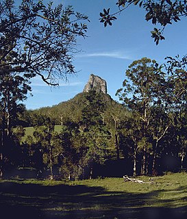
Glass House Mountains National Park is a heritage-listed national park at Glass House Mountains, Sunshine Coast Region, Queensland, Australia. It is also known as Beerburrum Forest Reserve 1. It is 70 km (43 mi) north of Brisbane and consists of a flat plain punctuated by rhyolite and trachyte volcanic plugs, the cores of extinct volcanoes that formed 27 million to 26 million years ago. The mountains would once have had pyroclastic exteriors, but these have eroded away.

Lane Cove River river in Australia

The Lane Cove River, a northern tributary of the Parramatta River, is a tide-dominated, drowned valley estuary west of Sydney Harbour, located in Sydney, New South Wales, Australia. The river is a tributary of the Parramatta River, winding through a bushland valley. It joins Parramatta River at Greenwich and Woolwich, where together they form an arm of Sydney Harbour.

Mount Warning Mountain in north-eastern New South Wales, Australia

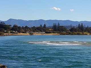
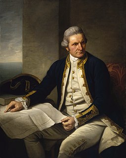
Mount Warning, a mountain in the Tweed Range in the Northern Rivers region of New South Wales, Australia, was formed from a volcanic plug of the now-gone Tweed Volcano. The mountain is located 14 kilometres (9 mi) west-south-west of Murwillumbah, near the border between New South Wales and Queensland. Lieutenant James Cook saw the mountain from the sea and named it Mount Warning.

Budawang Range

The Budawang Range, commonly called The Budawangs, a rugged mountain range within the Budawang National Park and the Morton National Park, are part of a spur off the Great Dividing Range and are located in the South Coast region of New South Wales, Australia.

Wolli Creek river in New South Wales, Australia

Wolli Creek is an urban watercourse of the Cooks River catchment located in the southern suburbs of Sydney, in New South Wales, Australia.

Kendall, New South Wales Town in New South Wales, Australia

Kendall is a town on the Mid North Coast of New South Wales, Australia.

Yerranderie town in New South Wales, Australia

Yerranderie is a ghost town located near Kanangra-Boyd National Park of New South Wales, Australia in Wollondilly Shire.

Mount Gulaga mountain in New South Wales, Australia

Mount Gulaga, also Gulaga, and formerly known as Mount Dromedary, a mountain located in the south coast region of New South Wales, Australia, rises above the village of Central Tilba and is within the Gulaga National Park. At its highest point, it measures 806 metres (2,644 ft) above sea level.

Point Lookout (New South Wales) mountain in New South Wales, Australia

Point Lookout, a mountain on the Snowy Range, a spur of the Great Dividing Range, is located in the New England National Park on the eastern edge of the Northern Tablelands in the New England region of New South Wales, Australia.

Werakata National Park Protected area in New South Wales, Australia

The Werakata National Park is a protected national park that is located in the Lower Hunter Region of New South Wales, in eastern Australia. The 3,337-hectare (8,250-acre) national park is located to the north, east and south of the town of Cessnock.

References

  1. 1 2 Dooragan National Park Culture & history Archived 30 September 2007 at the Wayback Machine . at the National Parks and Wildlife Service website
  2. Project Gutenberg volunteer effort to digitize and archive books

    Project Gutenberg (PG) is a volunteer effort to digitize and archive cultural works, to "encourage the creation and distribution of eBooks". It was founded in 1971 by American writer Michael S. Hart and is the oldest digital library. Most of the items in its collection are the full texts of public domain books. The project tries to make these as free as possible, in long-lasting, open formats that can be used on almost any computer. As of 23 June 2018, Project Gutenberg reached 57,000 items in its collection of free eBooks.

  3. Greater Port Macquarie Map, Edition 5, Cartoscope Touring Maps