The Kingsbridge Estuary in the South Hams area of Devon, England runs from Kingsbridge in the north to its mouth at the English Channel near Salcombe and lies between Bolt Head and Sharpitor to the west and Portlemouth Down to the east. The estuary is some 8.6 kilometres (5.3 mi) in length, with numerous side channels. Several of its creeks have independent names, including Blanksmill, Frogmore, Southpool, Batson and Bowcombe Creek.

South Pool is a village, parish and former manor in South Devon, England. It is situated 3 1/2 miles south-east of the town of Kingsbridge and 2 1/2 miles north-east of Salcombe. It is administered by the South Hams local authority. Historically it formed part of Coleridge Hundred. It falls within Woodleigh Deanery for ecclesiastical purposes. The village is in an area of outstanding natural beauty at the head of South Pool creek.

Leirvík is a town on the Faroe Islands and was an important regional ferry harbour at the east coast of the second-largest island Eysturoy. Leirvík has 925 inhabitants.
Central Hillside is a neighborhood in Duluth, Minnesota, United States; located directly uphill from the city's downtown. The neighborhood offers views of the city and lake.
Alton is a hamlet within the Town of Sodus, Wayne County, New York, United States. It is located six miles (10 km) southeast of the Village of Sodus and five miles (8 km) south of the Village of Sodus Point, at an elevation of 377 feet. The primary intersection in the hamlet is at N.Y. Route 14 and Ridge Road. N.Y. Route 104 passes just south of Alton.

The Shanghai New International Expo Center is an exhibition center in Pudong, Shanghai. It hosts many exhibitions, including the Shanghai Motor Show. It has also hosted the 2002 Tennis Masters Cup, where one of the halls was temporarily converted into a tennis court. With more than 100 exhibitions per year and a turnover rate of 27 (2015), SNIEC is one of the world's most successful exhibition venues.

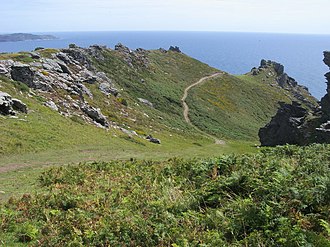
Bolt Tail is a headland in Devon, England, immediately to the southwest of Hope Cove in the South Hams district, at grid reference SX670397.

The Temecula Valley is a graben rift valley in western Riverside County, California.
Ligota Wielka is a village in the administrative district of Gmina Łagiewniki, in Dzierżoniów County, Lower Silesian Voivodeship, in south-western Poland. It lies approximately 6 kilometres (4 mi) south-west of Łagiewniki, 11 km (7 mi) east of Dzierżoniów, and 45 km (28 mi) south-west of the regional capital Wrocław.

Bolberry Down is a clifftop area on the coast of Devon, England. The headland of Bolt Tail lies to the west and Bolt Head and the town of Salcombe to the east. It is one of the longest coastal areas owned by the National Trust and lies within the South Devon Area of Outstanding Natural Beauty.
Zaborze is a village in the administrative district of Gmina Słomniki, within Kraków County, Lesser Poland Voivodeship, in southern Poland. It lies approximately 6 kilometres (4 mi) south-west of Słomniki and 19 km (12 mi) north-east of the regional capital Kraków.
Podmąchocice is a village in the administrative district of Gmina Górno, within Kielce County, Świętokrzyskie Voivodeship, in south-central Poland. It lies approximately 6 kilometres (4 mi) north-west of Górno and 13 km (8 mi) east of the regional capital Kielce.
Leopoldów is a village in the administrative district of Gmina Tarłów, within Opatów County, Świętokrzyskie Voivodeship, in south-central Poland. It lies approximately 8 kilometres (5 mi) south-east of Tarłów, 31 km (19 mi) north-east of Opatów, and 83 km (52 mi) east of the regional capital Kielce.
Doły Biskupie is a village in the administrative district of Gmina Kunów, within Ostrowiec County, Świętokrzyskie Voivodeship, in south-central Poland. It lies approximately 6 kilometres (4 mi) west of Kunów, 14 km (9 mi) west of Ostrowiec Świętokrzyski, and 43 km (27 mi) east of the regional capital Kielce.
Brzeście is a village in the administrative district of Gmina Bliżyn, within Skarżysko County, Świętokrzyskie Voivodeship, in south-central Poland. It lies approximately 3 kilometres (2 mi) east of Bliżyn, 10 km (6 mi) west of Skarżysko-Kamienna, and 28 km (17 mi) north-east of the regional capital Kielce.
Zdziechowice Drugie is a village in the administrative district of Gmina Zaklików, within Stalowa Wola County, Podkarpackie Voivodeship, in south-eastern Poland.

Dungy Head is a coastal promontory located west of Lulworth Cove on the Jurassic Coast in Dorset, England. It forms the eastern end of St Oswald's Bay. It is composed of Portland stone strata. The surrounding area is popular for coastal walks, which yield impressive views. Cliff-climbing however is dangerous and not recommended.
Tioga is an unincorporated community in Walker Township, Hancock County, Illinois, United States.

Fort Williams Park is a 90-acre park in Cape Elizabeth, Maine, encompassing numerous historical sites. Perhaps most famous for having Portland Head Light on its grounds, the park also encompasses the decommissioned and largely demolished United States Army post Fort Williams, which was operational during World War I and World War II.
Viscount Island is an island in the Central Coast region of British Columbia, situated on the east side of the southern entrance to Tribune Channel from lower Knight Inlet, to the southeast of Gilford Island. A narrow waterway, Sergeaunt Passage, separates it from the mainland to its east.