Headland

Last updated
Land's End, England Land's End - geograph.org.uk - 171343.jpg
Land's End, England

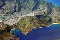
A headland, also known as a head, is a coastal landform, a point of land usually high and often with a sheer drop, that extends into a body of water. It is a type of promontory. A headland of considerable size often is called a cape. [1] Headlands are characterised by high, breaking waves, rocky shores, intense erosion, and steep sea cliff.

Contents

Headlands and bays are often found on the same coastline. A bay is flanked by land on three sides, whereas a headland is flanked by water on three sides. Headlands and bays form on discordant coastlines, where bands of rock of alternating resistance run perpendicular to the coast. Bays form when weak (less resistant) rocks (such as sands and clays) are eroded, leaving bands of stronger (more resistant) rocks (such as chalk, limestone, and granite) forming a headland, or peninsula. Through the deposition of sediment within the bay and the erosion of the headlands, coastlines eventually straighten out, then start the same process all over again.

List of notable headlands

Africa

Cape Malabata, Morocco Cape Malabata Lighthouse.jpg
Cape Malabata, Morocco

Asia

Europe

Cliffs at Beachy Head, England Beachy Head and Lighthouse, East Sussex, England - April 2010 crop horizon corrected.jpg
Cliffs at Beachy Head, England

North America

Point Reyes, California, USA Point Reyes National Seashore PORE2141.jpg
Point Reyes, California, USA

Canada

Greenland

Mexico

United States

Oceania

Hanauma Bay and Koko Crater at Koko Head, O'ahu Island, Hawai'i, USA Oahu from air2.jpg
Hanauma Bay and Koko Crater at Koko Head, O'ahu Island, Hawai'i, USA
Sydney Heads, New South Wales, Australia View from North Head Lookout - panoramio.jpg
Sydney Heads, New South Wales, Australia
South West Cape, Tasmania South Cape Bay 2.jpg
South West Cape, Tasmania

Australia

New Zealand

United States (Hawaii)

South America

Cape Horn, Chile CapeHorn.jpg
Cape Horn, Chile

See also

Related Research Articles

<span class="mw-page-title-main">Geography of Greenland</span>

Greenland is located between the Arctic Ocean and the North Atlantic Ocean, northeast of Canada and northwest of Iceland. The territory comprises the island of Greenland—the largest island in the world—and more than a hundred other smaller islands. Greenland has a 1.2-kilometer-long (0.75 mi) border with Canada on Hans Island. A sparse population is confined to small settlements along certain sectors of the coast. Greenland possesses the world's second-largest ice sheet.

<span class="mw-page-title-main">Geography of Mozambique</span>

The geography of Mozambique consists mostly of coastal lowlands with uplands in its center and high plateaus in the northwest. There are also mountains in the western portion. The country is located on the east coast of southern Africa, directly west of the island of Madagascar. Mozambique has a tropical climate with two seasons, a wet season from October to March and a dry season from April to September.

<span class="mw-page-title-main">Geography of Western Sahara</span>

Western Sahara is a territory in Northern Africa, bordered by the North Atlantic Ocean, Morocco proper, Algeria, and Mauritania. Geographic coordinates: 24°30′N13°00′W

The Cabot Trail is a scenic highway on Cape Breton Island in Nova Scotia, Canada. It is a 298 km (185 mi) loop around the northern tip of the island, passing along and through the Cape Breton Highlands and the Cape Breton Highlands National Park.

Cape Chidley is a headland located on the eastern shore of Killiniq Island, Canada, at the northeastern tip of the Labrador Peninsula.

<span class="mw-page-title-main">Cape Spear</span> Cape in Newfoundland and Labrador, Canada

Cape Spear is a headland located on the Avalon Peninsula of Newfoundland near St. John's in the Canadian province of Newfoundland and Labrador. At a longitude of 52°37' W, it is the easternmost point in Canada and North America, excluding Greenland.

<span class="mw-page-title-main">Cape Morris Jesup</span> Headland in northern Greenland

Cape Morris Jesup is a headland in Peary Land, Greenland.

<span class="mw-page-title-main">International Appalachian Trail</span> Long-distance hiking trail in Eastern United States and Canada

The International Appalachian Trail was originally a hiking trail which ran from Katahdin Woods and Waters National Monument, in Maine, through New Brunswick, to the Gaspé Peninsula of Quebec, after which it followed a ferry route to Newfoundland, and then continued to the northern-easternmost point of the Appalachian Mountains at Belle Isle, Newfoundland and Labrador. As of July 2020, there are widely geographically dispersed IAT-branded walking trails in Greenland, Iceland, Norway, Sweden, Denmark, Scotland, Northern Ireland, Ireland, Isle of Man, Wales, England, Spain, Portugal, and Morocco.

This is a list of extreme points in Antarctica.

<span class="mw-page-title-main">Cape (geography)</span> Large headland extending into a body of water, usually the sea

In geography, a cape is a headland, peninsula or promontory extending into a body of water, usually a sea. A cape usually represents a marked change in trend of the coastline, often making them important landmarks in sea navigation. This also makes them prone to natural forms of erosion, mainly tidal actions, resulting in a relatively short geological lifespan. Capes can be formed by glaciers, volcanoes, and changes in sea level. Erosion plays a large role in each of these methods of formation.

Cape Farewell is a headland on the southern shore of Egger Island, Nunap Isua Archipelago, Greenland. As the southernmost point of the country, it is one of the important landmarks of Greenland.

Land's End is a headland on the Penwith peninsula, located near Penzance in Cornwall, England, United Kingdom.

<span class="mw-page-title-main">Nordostrundingen</span>

Nordostrundingen, is a headland located at the northeastern end of Greenland. Administratively it is part of the Northeast Greenland National Park.

Cape Norman is a barren, limestone headland located at the northernmost point of insular Newfoundland in the Canadian province of Newfoundland and Labrador.

<span class="mw-page-title-main">Killiniq Island</span> Remote island in northeastern Canada

Killiniq Island is a remote island in southeastern Nunavut and northern Newfoundland and Labrador, Canada. Located at the extreme northern tip of Labrador between Ungava Bay and the Labrador Sea, it is notable in that it contains the only land border between Nunavut and Newfoundland and Labrador. Most other islands off the northern coast of Quebec and Labrador belong exclusively to Nunavut. Some cartographic sources do not correctly show the island's geopolitical boundaries; for instance, the Commission de toponymie du Québec seems to show it as belonging to Quebec.

<span class="mw-page-title-main">Cape St. Francis (Newfoundland and Labrador)</span> Headland on Newfoundland, Canada

The headland of Cape St. Francis is the outer extremity marking the boundary of Conception Bay on the Avalon Peninsula of the island of Newfoundland in the Canadian province of Newfoundland and Labrador. The International Maritime Organization also designates Cape St. Francis as the southern extremity of the Labrador Sea.

<span class="mw-page-title-main">Cape St. Mary's</span> Cape in southeast Newfoundland, Canada

The headland of Cape St. Mary's is located at the southern tip of the south-western arm of the Avalon Peninsula of the island of Newfoundland in the Canadian province of Newfoundland and Labrador.

<span class="mw-page-title-main">Newfoundland (island)</span> Island portion of Newfoundland and Labrador, Canada

Newfoundland is a large island within the Canadian province of Newfoundland and Labrador. It is situated off the eastern coast of the North American mainland and the geographical region of Labrador.

References

  1. Whittow, John (1984). Dictionary of Physical Geography. London: Penguin, 1984, pp. 80, 246. ISBN   0-14-051094-X.