Sussex County is a county in the southern part of the U.S. state of Delaware, on the Delmarva Peninsula. As of the 2020 census, the population was 237,378, making it the state's second most populated county only behind New Castle and ahead of Kent. The county seat is Georgetown.

Lewes is an incorporated city on the Delaware Bay in eastern Sussex County, Delaware, United States. According to the 2020 census, its population was 3,303. Along with neighboring Rehoboth Beach, Lewes is one of the principal cities of Delaware's rapidly growing Cape Region. The city lies within the Salisbury, Maryland–Delaware Metropolitan Statistical Area. Lewes proudly claims to be "The First Town in The First State."
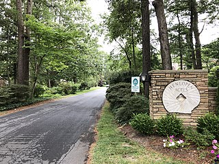
Henlopen Acres is a municipality north of Rehoboth Beach in Sussex County, Delaware, United States, and is the third smallest incorporated town in Delaware. According to 2010 census figures, the population of the town is 122, a 12.2% decrease from the 2000 census. It is part of the Salisbury, Maryland-Delaware Metropolitan Statistical Area.
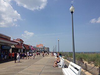
Rehoboth Beach is a city on the Atlantic Ocean along the Delaware Beaches in eastern Sussex County, Delaware, United States. As of 2020, its population was 1,108. Along with the neighboring coastal town of Lewes, Rehoboth Beach is one of the principal cities of Delaware's rapidly growing Cape Region. Rehoboth Beach lies within the Salisbury metropolitan area.
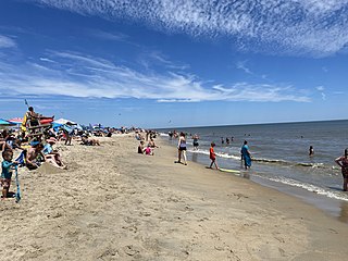
Cape Henlopen State Park is a Delaware state park on 5,193 acres (2,102 ha) on Cape Henlopen in Sussex County, Delaware, in the United States. William Penn made the beaches of Cape Henlopen one of the first public lands established in what has become the United States in 1682 with the declaration that Cape Henlopen would be for "the usage of the citizens of Lewes and Sussex County." Cape Henlopen State Park has a 24-hour and year-round fishing pier as well as campgrounds. The remainder of the park is only open from sunrise to sunset, and includes a bathhouse on the Atlantic Ocean, an area for surf-fishing, a disc golf course, and bicycle and walking paths. The beach at Herring Point is a popular surfing spot. The park is a stop on Delaware's Coastal Heritage Greenway.

The Cape May–Lewes Ferry is a ferry system in the United States that traverses a 17-mile (27 km) crossing of the Delaware Bay connecting North Cape May, New Jersey with Lewes, Delaware. The ferry constitutes a portion of U.S. Route 9 and is the final crossing of the Delaware River-Delaware Bay waterway before it meets the Atlantic Ocean. It is only one of two direct crossings between Delaware and New Jersey, the other being the Delaware Memorial Bridge.

Cape May consists of a peninsula and barrier island system in the U.S. state of New Jersey. It is roughly coterminous with Cape May County and runs southwards from the New Jersey mainland, separating Delaware Bay from the Atlantic Ocean. The southernmost point in both New Jersey and the northeastern United States lies on the cape. A number of resort communities line the Atlantic side of the cape, including Ocean City, the most populous community on the cape, The Wildwoods, known for its architecturally significant hotel district, and the city of Cape May, which has served as a resort community since the mid-1700s, making it the oldest such resort in the U.S.

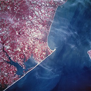
Delaware Bay is the estuary outlet of the Delaware River on the northeast seaboard of the United States, lying between the states of Delaware and New Jersey. It is approximately 782 square miles (2,030 km2) in area, the bay's freshwater mixes for many miles with the saltwater of the Atlantic Ocean.
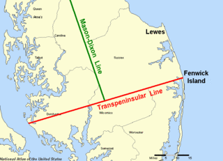
The Transpeninsular Line is a surveyed line, the eastern half of which forms the north–south border between Delaware and Maryland. The border turns roughly north from the midpoint of the line towards the Twelve-Mile Circle, which forms much of the remainder of the Delaware land border.

Fort Miles was a United States Army World War II installation located on Cape Henlopen near Lewes, Delaware. Although funds to build the fort were approved in 1934, it was 1938 before construction began on the fort. On 3 June 1941 it was named for Lieutenant General Nelson A. Miles.
Cornelis Jacobsen Mey, often spelled Cornelius Jacobsz May in Dutch, was a 17th-century Dutch explorer, captain, and fur trader. Mey was the first director of New Netherland and was stationed at Fort Amsterdam. Mey was the captain of the ship Nieu Nederlandt, which delivered the first boatload of colonists to New Netherland in north-east America.
The Junction and Breakwater Trail is a 6-mile (9.7 km) long rail trail located on the southwestern side of Cape Henlopen State Park connecting Lewes and Rehoboth Beach, Delaware, United States. It is the third rail trail built in Delaware and it is the longest in the state. It partially follows the former Pennsylvania Railroad Rehoboth Beach branch that once transported passengers to several Methodist resort camps along the Atlantic coast. The line was abandoned by the Penn Central in the early 1970s.

In Lewes, Delaware the Zwaanendael Museum was created to honor the 300th anniversary of Delaware's first European settlement, Zwaanendael, founded 1631. The museum models the former City Hall in Hoorn, Netherlands. It has 17th century Dutch elements such as stepped facade gable, terra cotta roof tiles, carved stonework, and decorated shutters. The top of the building's front features a statue of David Pietersen de Vries, leader of the expedition that founded Swanendael.

The Harbor of Refuge Light is a lighthouse built on the ocean end of the outer Delaware Breakwater at the mouth of the Delaware Bay, just off Cape Henlopen. It was built to function with the Delaware Breakwater East End Light in order to mark the National Harbor of Refuge.
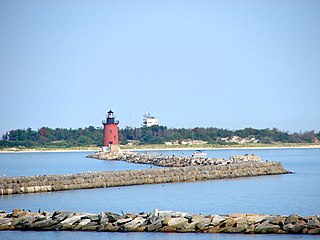
The Delaware Breakwater East End Light is a lighthouse located on the inner Delaware Breakwater in the Delaware Bay, just off the coast of Cape Henlopen and the town of Lewes, Delaware.

Cape Henlopen Light was a lighthouse near Lewes, in present-day Cape Henlopen State Park, Delaware, United States. The lighthouse was on the north side of the Great Dune on Cape Henlopen, Delaware. It was the sixth lighthouse built in the colonies.
The Delaware Breakwater is a set of breakwaters east of Lewes, Delaware on Cape Henlopen that form Lewes Harbor. They were listed on the National Register of Historic Places on December 12, 1976.

The National Harbor of Refuge and Delaware Breakwater Historic District encompasses a series of seacoast breakwaters behind Cape Henlopen, Delaware, built between 1828 and 1898 to establish a shipping haven on a coastline that lacked safe harbors. The Harbor of Refuge is at the mouth of the Delaware Bay estuary where it opens into the Atlantic Ocean, at Lewes.

Thijmen Jacobsz Hinlopen, was one of the leaders of the Dutch merchant and whaling company of Noordsche Compagnie beginning in 1617 and participant in the New Netherland Company, interested in furs. Thijmen was a prominent trader in corn from the Baltic carrying on trade to Genoa and Portugal.
The Delaware Breakwater Range Rear Light was a lighthouse west of Lewes, Delaware. It was made obsolete by the shifting of Cape Henlopen and was disassembled and moved to Florida to become the Boca Grande Entrance Range Rear Light.