45th parallel north

Last updated
World location map (equirectangular 180).svg
45°
45th parallel north
Map all coordinates using: OpenStreetMap

The 45th parallel north is a circle of latitude that is 45 degrees north of Earth's equator. It crosses Europe, Asia, the Pacific Ocean, North America, and the Atlantic Ocean. The 45th parallel north is often called the halfway point between the equator and the North Pole, but the true halfway point is 16.0 km (9.9 mi) north of it (approximately between 45°08'36" and 45°08'37") because Earth is an oblate spheroid; that is, it bulges at the equator and is flattened at the poles. [1]

Contents

At this latitude, the sun is visible for 15 hours 37 minutes during the summer solstice, and 8 hours 46 minutes during the winter solstice. The midday Sun stands 21.6° above the southern horizon at the December solstice, 68.4° at the June solstice, and exactly 45.0° at either equinox. [2]

Around the world

Starting at the Prime Meridian and heading eastwards, the parallel 45° north passes through:

Co-ordinatesCountry, territory
or sea
Notes
45°0′N0°0′E / 45.000°N 0.000°E / 45.000; 0.000 (Prime Meridian) Flag of France.svg  France Aquitaine
Midi-Pyrénées
Limousin
Auvergne
Rhône-Alpes – passing just south of Grenoble
45°0′N6°44′E / 45.000°N 6.733°E / 45.000; 6.733 (Italy) Flag of Italy.svg  Italy Piedmont – passing just south of Turin
Lombardy - passing by Voghera and Mantua
Emilia-Romagna – passing just south of Piacenza
Lombardy
Veneto – passing just south of Rovigo
45°0′N12°27′E / 45.000°N 12.450°E / 45.000; 12.450 (Adriatic Sea) Adriatic Sea Gulf of Venice
45°0′N13°44′E / 45.000°N 13.733°E / 45.000; 13.733 (Croatia) Flag of Croatia.svg  Croatia Istrian Peninsula, islands of Cres and Krk, and the mainland again
45°0′N15°46′E / 45.000°N 15.767°E / 45.000; 15.767 (Bosnia and Herzegovina) Flag of Bosnia and Herzegovina.svg  Bosnia and Herzegovina
45°0′N18°44′E / 45.000°N 18.733°E / 45.000; 18.733 (Croatia) Flag of Croatia.svg  Croatia
45°0′N19°6′E / 45.000°N 19.100°E / 45.000; 19.100 (Serbia) Flag of Serbia.svg  Serbia Passing through the centre of Ruma and through northern part of Sremska Mitrovica
Passing through the northern edge of Stara Pazova, 30 kilometres NW of Belgrade
45°0′N21°24′E / 45.000°N 21.400°E / 45.000; 21.400 (Romania) Flag of Romania.svg  Romania Passing just north of Ploiești and just south of Târgu Jiu and Râmnicu Vâlcea
45°0′N29°39′E / 45.000°N 29.650°E / 45.000; 29.650 (Black Sea) Black Sea
45°0′N33°36′E / 45.000°N 33.600°E / 45.000; 33.600 (Ukraine) Crimea Controlled by Flag of Russia.svg  Russia, claimed by Flag of Ukraine.svg  Ukraine – passing just north of Simferopol, and just south of Feodosiya
45°0′N35°24′E / 45.000°N 35.400°E / 45.000; 35.400 (Black Sea) Black Sea
45°0′N37°13′E / 45.000°N 37.217°E / 45.000; 37.217 (Russia) Flag of Russia.svg  Russia Passing just south of Krasnodar, and just south of Stavropol
45°0′N47°15′E / 45.000°N 47.250°E / 45.000; 47.250 (Caspian Sea) Caspian Sea
45°0′N51°4′E / 45.000°N 51.067°E / 45.000; 51.067 (Kazakhstan) Flag of Kazakhstan.svg  Kazakhstan Mangystau Province
45°0′N56°0′E / 45.000°N 56.000°E / 45.000; 56.000 (Uzbekistan) Flag of Uzbekistan.svg  Uzbekistan Karakalpakstan (autonomous republic) – including Vozrozhdeniya Island in the Aral Sea
45°0′N59°50′E / 45.000°N 59.833°E / 45.000; 59.833 (Kazakhstan) Flag of Kazakhstan.svg  Kazakhstan Kyzylorda Province
South Kazakhstan Province
Zhambyl Province
Almaty Province
45°0′N80°2′E / 45.000°N 80.033°E / 45.000; 80.033 (China) Flag of the People's Republic of China.svg  People's Republic of China Xinjiang – passing through a 45×90 point (halfway between the North Pole and the Equator, and halfway between the Prime Meridian and the 180th meridian)
45°0′N93°13′E / 45.000°N 93.217°E / 45.000; 93.217 (Mongolia) Flag of Mongolia.svg  Mongolia Govi-Altai Province
Bayankhongor Province
Övörkhangai Province
Dundgovi Province
Dornogovi Province
45°0′N111°46′E / 45.000°N 111.767°E / 45.000; 111.767 (China) Flag of the People's Republic of China.svg  People's Republic of China Inner Mongolia
45°0′N112°31′E / 45.000°N 112.517°E / 45.000; 112.517 (Mongolia) Flag of Mongolia.svg  Mongolia Sükhbaatar Province
45°0′N114°7′E / 45.000°N 114.117°E / 45.000; 114.117 (China) Flag of the People's Republic of China.svg  People's Republic of China Inner Mongolia
Jilin
Heilongjiang
45°0′N131°30′E / 45.000°N 131.500°E / 45.000; 131.500 (Russia) Flag of Russia.svg  Russia Primorsky Krai - passing through Lake Khanka
45°0′N136°37′E / 45.000°N 136.617°E / 45.000; 136.617 (Sea of Japan) Sea of Japan Passing just south of Rishiri Island, Flag of Japan.svg  Japan
45°0′N141°41′E / 45.000°N 141.683°E / 45.000; 141.683 (Japan) Flag of Japan.svg  Japan Hokkaidō
45°0′N142°32′E / 45.000°N 142.533°E / 45.000; 142.533 (Sea of Okhotsk) Sea of Okhotsk
45°0′N147°31′E / 45.000°N 147.517°E / 45.000; 147.517 (Kuril Islands) Kuril Islands Island of Iturup, administered by Flag of Russia.svg  Russia, claimed by Flag of Japan.svg  Japan
45°0′N147°59′E / 45.000°N 147.983°E / 45.000; 147.983 (Pacific Ocean) Pacific Ocean
45°0′N124°1′W / 45.000°N 124.017°W / 45.000; -124.017 (United States) Flag of the United States (23px).png  United States Oregon – passing just north of Salem
Idaho
Montana
Montana / Wyoming border
South Dakota
Minnesota – passing through Minneapolis and suburbs of St Paul MN
Wisconsin – passing through a 45×90 point (halfway between the North Pole and the Equator, and halfway between the Prime Meridian and the 180th meridian)
45°0′N87°37′W / 45.000°N 87.617°W / 45.000; -87.617 (Lake Michigan) Lake Michigan Green Bay – territorial waters of the United States
45°0′N87°21′W / 45.000°N 87.350°W / 45.000; -87.350 (United States) Flag of the United States (23px).png  United States WisconsinDoor Peninsula
45°0′N87°9′W / 45.000°N 87.150°W / 45.000; -87.150 (Lake Michigan) Lake Michigan Territorial waters of the United States
45°0′N86°9′W / 45.000°N 86.150°W / 45.000; -86.150 (United States) Flag of the United States (23px).png  United States MichiganSouth Manitou Island
45°0′N86°5′W / 45.000°N 86.083°W / 45.000; -86.083 (Lake Michigan) Lake Michigan Territorial waters of the United States
45°0′N85°46′W / 45.000°N 85.767°W / 45.000; -85.767 (United States) Flag of the United States (23px).png  United States MichiganLeelanau Peninsula (Leelanau County)
45°0′N86°5′W / 45.000°N 86.083°W / 45.000; -86.083 (Lake Michigan) Lake Michigan Grand Traverse Bay – territorial waters of the United States
45°0′N85°47′W / 45.000°N 85.783°W / 45.000; -85.783 (United States) Flag of the United States (23px).png  United States Michigan (Antrim County, Otsego County, Montmorency County, and Alpena County)
45°0′N83°26′W / 45.000°N 83.433°W / 45.000; -83.433 (Lake Huron) Lake Huron Territorial waters of the United States and Canada
45°0′N81°27′W / 45.000°N 81.450°W / 45.000; -81.450 (Canada) Flag of Canada (Pantone).svg  Canada OntarioBruce Peninsula
45°0′N81°11′W / 45.000°N 81.183°W / 45.000; -81.183 (Lake Huron) Lake Huron Georgian Bay – territorial waters of Canada
45°0′N79°59′W / 45.000°N 79.983°W / 45.000; -79.983 (Canada) Flag of Canada (Pantone).svg  Canada Ontario
45°0′N74°54′W / 45.000°N 74.900°W / 45.000; -74.900 (United States) Flag of the United States (23px).png  United States New York state – for about 10 km (6.21 mi)
45°0′N74°46′W / 45.000°N 74.767°W / 45.000; -74.767 (Canada) Flag of Canada (Pantone).svg  Canada OntarioCornwall Island
Quebec – running just north of the border with New York, Flag of the United States (23px).png  United States
45°0′N73°54′W / 45.000°N 73.900°W / 45.000; -73.900 (United States) Flag of the United States (23px).png  United States New York – running just south of the border with Quebec, Flag of Canada (Pantone).svg  Canada
Vermont – running just south of the border with Quebec, Flag of Canada (Pantone).svg  Canada
New Hampshire
Maine
45°0′N67°4′W / 45.000°N 67.067°W / 45.000; -67.067 (Passamaquoddy Bay) Passamaquoddy Bay
45°0′N67°0′W / 45.000°N 67.000°W / 45.000; -67.000 (Canada) Flag of Canada (Pantone).svg  Canada Deer Island, New Brunswick
45°0′N66°57′W / 45.000°N 66.950°W / 45.000; -66.950 (Bay of Fundy) Bay of Fundy Territorial waters of Canada
45°0′N65°10′W / 45.000°N 65.167°W / 45.000; -65.167 (Canada) Flag of Canada (Pantone).svg  Canada Nova Scotia – passing just north of Fort Edward
45°0′N61°57′W / 45.000°N 61.950°W / 45.000; -61.950 (Atlantic Ocean) Atlantic Ocean
45°0′N1°12′W / 45.000°N 1.200°W / 45.000; -1.200 (France) Flag of France.svg  France Aquitaine – passing just north of Bordeaux

Europe

Sundial at the 45th parallel in Senj, Croatia. Suncanik Senj 45 paralela 07.jpg
Sundial at the 45th parallel in Senj, Croatia.

In Europe the 45th parallel hits the Bay of Biscay coast of France in the west. It crosses the river Rhône at Pont-de-l'Isère, just north of Valence, Drôme and through Grenoble. It then continues across the Massif Central and into the Aquitaine region. The city of Bordeaux is just south of the parallel. East of Bordeaux, in the municipality of Saint Seurin sur l'Isle, it intersects the Prime Meridian in the corner of an unremarkable field by the side of the A89 highway. There is no marker or other indication of this singular point on the parallel. It can, however, be visited easily by taking secondary roads from Saint Seurin and consulting a standard GPS signal.

In northern Italy it parallels the river Po, near Rovigo, passing by the southern province of Mantova, Piacenza in Emilia-Romagna, Voghera, then just south of Turin before passing into France in the Cottian Alps.

Further east it passes through the Balkans: Romania (just north of Ploiești, and through Târgu Jiu), the Serbian autonomous province of Vojvodina, the eastern tip of Croatia, the northern edge of Bosnia and Herzegovina, and a section of Adriatic Croatia. The capital city of SerbiaBelgrade is just south of the parallel.

In Russia it runs from the west coast of the Caspian Sea to the east coast of the Black Sea, through the Republic of Kalmykia, Stavropol Krai and its capital Stavropol, and Krasnodar Krai and its capital Krasnodar. In Ukraine it crosses the Crimea and its capital Simferopol.

Asia

After leaving Russia the parallel passes through southern Kazakhstan, skirting the northern edge of the Ustyurt Plateau. It intersects the city of Burylbaytal at the southern tip of Lake Balkhash and the city of Qyzylorda further west. At the border with Uzbekistan it bisects the Aral Sea and its toxic Vozrozhdeniya Island peninsula, site of an abandoned Soviet bioweapons laboratory.

In northwest China it passes through the Ili Kazakh Autonomous Prefecture in Xinjiang and the oil city of Karamay. Transecting southern Mongolia it passes through the provinces of Sükhbaatar, Dornogovi (and its capital Sainshand), Dundgovi, Övörkhangai, Bayankhongor, Govi-Altai, and Khovd. At Khanka Lake it enters northeast China, cutting across Heilongjiang and continuing through part of Jilin and eastern Inner Mongolia.

It leaves the Asian mainland on the coast of Primorsky Krai in Russia, north of Vladivostok and continues through the northern part of the Sea of Japan. It passes through Rishiri-Rebun-Sarobetsu National Park and the adjacent town of Horonobe on the northern tip of Hokkaidō, the northernmost of Japan's main islands, before heading east across the North Pacific Ocean.

North America

The part of the 45th parallel called the Collins-Valentine line defines part of the international border between Quebec, Canada, and New York and Vermont, United States. 45th parallel US Canada.svg
The part of the 45th parallel called the Collins–Valentine line defines part of the international border between Quebec, Canada, and New York and Vermont, United States.
The 45th parallel defines most of the border between Montana and Wyoming in the United States. 45th parallel US.svg
The 45th parallel defines most of the border between Montana and Wyoming in the United States.

Throughout the United States the parallel is marked in many places on highways by a sign proclaiming that the location is halfway between the North Pole and the equator. [3] [4] [N 1]

The 45th parallel forms some boundaries of or passes through many U.S. states: Oregon, Idaho, Montana, Wyoming, South Dakota, Minnesota, Wisconsin, Michigan, New York, Vermont, New Hampshire and Maine, as well as going through the Canadian provinces of Ontario, Quebec, New Brunswick and Nova Scotia. The parallel once formed the northern boundary of the original Colony of Virginia, as outlined in the London Company charter. [5]

Going from west to east, the line makes landfall at the Pacific coast in Oregon. After crossing Idaho and the Rocky Mountains, it makes up most of the boundary between Montana and Wyoming. It then passes through the Great Plains and continues further East directly through Minneapolis, MN.

In Michigan, the Old Mission Peninsula in Grand Traverse Bay ends just shy of the 45th parallel. Many guidebooks and signs at the Mission Point Lighthouse describe it as being halfway between the equator and north pole. When the Grand Traverse Bay recedes below normal level, it is possible to walk out to the exact line.

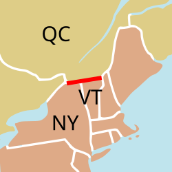
Further east, the 45th parallel roughly marks the Canada–United States border between the St. Lawrence and Connecticut rivers, between the Canadian province of Quebec and the states of New York and Vermont. The parallel is sometimes called the "Canada line" or the Collins–Valentine line. After the Seven Years' War, the 45th parallel was declared the boundary between New York and Quebec. Under the Webster–Ashburton Treaty of 1842, original measurement errors stand so that the boundary is not exactly at 45 degrees north but is where the survey monuments were erected in 1772. The actual boundary of Vermont lies approximately 1 kilometre (3,300 ft) north of the parallel due to an error in the 1772 survey. [6]

All of mainland New Brunswick lies north of the 45th parallel. Approximately two-thirds of Deer Island, plus all of Campobello and Grand Manan islands, are south of the 45th parallel.

The parallel roughly bisects mainland Nova Scotia. Halifax is approximately 40 km (25 mi) south of the parallel.

See also

Notes

  1. Due to the fact that the Earth's equatorial radius is not exactly the same as its polar radius, the 45th parallel line is not exactly half way between the equator and the north pole when traversing the surface of the Earth. The 45th parallel line represents a perfect angle bisector between the equator and the north pole when seen from the Earth's center. See this image of a sign on the 45th parallel south for exact distance values.

Related Research Articles

A solar equinox is a moment in time when the Sun crosses the Earth's equator, which is to say, appears directly above the equator, rather than north or south of the equator. On the day of the equinox, the Sun appears to rise "due east" and set "due west". This occurs twice each year, around 20 March and 23 September.

<span class="mw-page-title-main">Northern Hemisphere</span> Half of Earth that is north of the Equator

The Northern Hemisphere is the half of Earth that is north of the Equator. For other planets in the Solar System, north is defined as being in the same celestial hemisphere relative to the invariable plane of the Solar System as Earth's North Pole.

A solstice is an event that occurs when the Sun reaches its most northerly or southerly excursion relative to the celestial equator on the celestial sphere. Two solstices occur annually, around June 21 and December 21. In many countries, the seasons of the year are determined by the solstices and the equinoxes.

<span class="mw-page-title-main">Tropic of Cancer</span> Line of northernmost latitude at which the Sun can be directly overhead

The Tropic of Cancer, which is also referred to as the Northern Tropic, is the most northerly circle of latitude on Earth at which the Sun can be directly overhead. This occurs on the June solstice, when the Northern Hemisphere is tilted toward the Sun to its maximum extent. It also reaches 90 degrees below the horizon at solar midnight on the December Solstice. Using a continuously updated formula, the circle is currently 23°26′10.2″ (or 23.43615°) north of the Equator.

<span class="mw-page-title-main">Tropic of Capricorn</span> Line of southernmost latitude at which the sun can be directly overhead

The Tropic of Capricorn is the circle of latitude that contains the subsolar point at the December solstice. It is thus the southernmost latitude where the Sun can be seen directly overhead. It also reaches 90 degrees below the horizon at solar midnight on the June Solstice. Its northern equivalent is the Tropic of Cancer.

<span class="mw-page-title-main">Circle of latitude</span> Geographic notion

A circle of latitude or line of latitude on Earth is an abstract east–west small circle connecting all locations around Earth at a given latitude coordinate line.

The 49th parallel north is a circle of latitude that is 49° north of Earth's equator. It crosses Europe, Asia, the Pacific Ocean, North America, and the Atlantic Ocean.

The 42nd parallel north is a circle of latitude that is 42 degrees north of the Earth's equatorial plane. It crosses Europe, the Mediterranean Sea, Asia, the Pacific Ocean, North America, and the Atlantic Ocean.

<span class="mw-page-title-main">45th parallel south</span> Circle of latitude

The 45th parallel south is a circle of latitude that is 45° south of the Earth's equator.

<span class="mw-page-title-main">Theodore Wirth Park</span> Urban park in Minneapolis

Theodore Wirth Park is the regional park managed by the Minneapolis Park and Recreation Board. The park land is shared by Minneapolis and the neighboring suburb of Golden Valley. Formally named Theodore Wirth Regional Park, it includes two golf courses, Wirth Lake, Birch Pond, cross-country ski trails, mountain biking trails, snow tubing hills, and other amenities. It forms a significant portion of the Grand Rounds Scenic Byway, linking the Chain of Lakes area with the Victory Memorial Parkway.

The 30th parallel north is a circle of latitude that is 30 degrees north of the Earth's equatorial plane. It stands one-third of the way between the equator and the North Pole and crosses Africa, Asia, the Pacific Ocean, North America and the Atlantic Ocean. The parallel is used in some contexts to delineate Europe or what is associated with the continent of Europe as a southernmost limit, e.g. to qualify for membership of the European Broadcasting Union.

The 45×90 points are the four points on Earth which are both halfway between one of the geographical poles and the equator, and halfway between the Prime Meridian and the 180th meridian. Both northern 45×90 points are located on land, while both southern 45×90 points are in remote open ocean locations.

The 36th parallel north is a circle of latitude that is 36 degrees north of the Earth's equatorial plane. It crosses Africa, the Mediterranean Sea, Asia, the Pacific Ocean, North America and the Atlantic Ocean. In the ancient Mediterranean world, its role for navigation and geography was similar to that played by the Equator today.

<span class="mw-page-title-main">Daytime</span> Period of a day in which a location experiences natural illumination

Daytime as observed on Earth is the period of the day during which a given location experiences natural illumination from direct sunlight. Daytime occurs when the Sun appears above the local horizon, that is, anywhere on the globe's hemisphere facing the Sun. In direct sunlight the movement of the sun can be recorded and observed using a sundial that casts a shadow that slowly moves during the day. Other planets and natural satellites that rotate relative to a luminous primary body, such as a local star, also experience daytime, but this article primarily discusses daytime on Earth.

<span class="mw-page-title-main">Sun path</span> Arc-like path that the Sun appears to follow across the sky

Sun path, sometimes also called day arc, refers to the daily and seasonal arc-like path that the Sun appears to follow across the sky as the Earth rotates and orbits the Sun. The Sun's path affects the length of daytime experienced and amount of daylight received along a certain latitude during a given season.

The 60th parallel north is a circle of latitude that is 60 degrees north of Earth's equator. It crosses Europe, Asia, the Pacific Ocean, North America, and the Atlantic Ocean.

The 30th parallel south is a circle of latitude that is 30 degrees south of the Earth's equator. It stands one-third of the way between the equator and the South Pole and crosses Africa, the Indian Ocean, Australia, the Pacific Ocean, South America and the Atlantic Ocean.

The meridian 90° west of Greenwich is a line of longitude that extends from the North Pole across the Arctic Ocean, North America, the Gulf of Mexico, Central America, the Pacific Ocean, the Southern Ocean, and Antarctica to the South Pole.

<span class="mw-page-title-main">Equator</span> Imaginary line halfway between Earths North and South poles

The equator is a circle of latitude that divides a spheroid, such as Earth, into the Northern and Southern hemispheres. On Earth, the Equator is an imaginary line located at 0 degrees latitude, about 40,075 km (24,901 mi) in circumference, halfway between the North and South poles. The term can also be used for any other celestial body that is roughly spherical.

<span class="mw-page-title-main">Arctic Circle</span> Boundary of the Arctic

The Arctic Circle is one of the two polar circles, and the most northerly of the five major circles of latitude as shown on maps of Earth at about 66° 34' N. Its southern equivalent is the Antarctic Circle.

References

  1. "The Half-Way to the Pole Line". 2 May 2006. Archived from the original on 2 May 2006. Retrieved 16 July 2018.
  2. "Duration of Daylight/Darkness Table for One Year". U.S. Naval Observatory. 2019-09-24. Archived from the original on 2019-10-12. Retrieved 2021-03-10.
  3. "Concord Monitor: "New Hampshire is halfway between the equator and the North Pole – just don't ask where"". concordmonitor.com. Retrieved 19 April 2018.
  4. Brown, K. Williams (July 10, 2011). "The beauty of halfwayism". Statesman Journal . Salem, Oregon. p. 5D. Retrieved July 9, 2018 via Newspapers.com. Lock-green.svg
  5. "The First Charter of Virginia; April 10, 1606". The Avalon Project. 2008.
  6. "The Canada–U.S. Border – Townships Heritage WebMagazine". townshipsheritage.com. Retrieved 19 April 2018.