Northern Hemisphere

Last updated
Northern Hemisphere shaded blue. The hemispheres appear unequal here because Antarctica is not shown. Global hemispheres.svg
Northern Hemisphere shaded blue. The hemispheres appear unequal here because Antarctica is not shown.
Northern Hemisphere from above the North Pole Northern Hemisphere LamAz.png
Northern Hemisphere from above the North Pole

The Northern Hemisphere is the half of Earth that is north of the Equator. For other planets in the Solar System, north is defined as being in the same celestial hemisphere relative to the invariable plane of the Solar System as Earth's North Pole. [1]

Contents

Due to Earth's axial tilt of 23.439281°, winter in the Northern Hemisphere lasts from the December solstice (typically December 21 UTC) to the March equinox (typically March 20 UTC), while summer lasts from the June solstice through to the September equinox (typically on 23 September UTC). The dates vary each year due to the difference between the calendar year and the astronomical year. Within the Northern Hemisphere, oceanic currents can change the weather patterns that affect many factors within the north coast. Such events include El Niño–Southern Oscillation.

Trade winds blow from east to west just above the equator. The winds pull surface water with them, creating currents, which flow westward due to the Coriolis effect. The currents then bend to the right, heading north. At about 30 degrees north latitude, a different set of winds, the westerlies, push the currents back to the east, producing a closed clockwise loop. [2]

Its surface is 60.7% water, compared with 80.9% water in the case of the Southern Hemisphere, and it contains 67.3% of Earth's land. [3] The continents of North America and mainland Eurasia are located entirely in the Northern Hemisphere, together with about two-thirds of Africa and a small part of South America.

Geography and climate
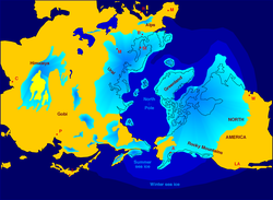
During the 2.5 million years of the Pleistocene, numerous cold phases called glacials (Quaternary ice age), or significant advances of continental ice sheets, in Europe and North America, occurred at intervals of approximately 40,000 to 100,000 years. The long glacial periods were separated by more temperate and shorter interglacials which lasted about 10,000–15,000 years. The last cold episode of the last glacial period ended about 10,000 years ago. [4] Earth is currently in an interglacial period of the Quaternary, called the Holocene. [5] The glaciations that occurred during the glacial period covered many areas of the Northern Hemisphere.

The Arctic is a region around the North Pole (90° latitude). Its climate is characterized by cold winters and cool summers. Precipitation mostly comes in the form of snow. Areas inside the Arctic Circle (66°34′ latitude) experience some days in summer when the Sun never sets, and some days during the winter when it never rises. The duration of these phases varies from one day for locations right on the Arctic Circle to several months near the Pole, which is the middle of the Northern Hemisphere.

Northern hemisphere glaciation during the last ice ages. The setup of 3 to 4 kilometer thick ice sheets caused a sea level lowering of about 120 m. Northern icesheet hg.png
Northern hemisphere glaciation during the last ice ages. The setup of 3 to 4 kilometer thick ice sheets caused a sea level lowering of about 120 m.

Between the Arctic Circle and the Tropic of Cancer (23°26′ latitude) lies the Northern temperate zone. The changes in these regions between summer and winter are generally mild, rather than extreme hot or cold. However, a temperate climate can have very unpredictable weather.

Tropical regions (between the Tropic of Cancer and the Equator, 0° latitude) are generally hot all year round and tend to experience a rainy season during the summer months, and a dry season during the winter months.

In the Northern Hemisphere, objects moving across or above the surface of the Earth tend to turn to the right because of the Coriolis effect. As a result, large-scale horizontal flows of air or water tend to form clockwise-turning gyres. [6] These are best seen in ocean circulation patterns in the North Atlantic and North Pacific oceans. [6] Within the Northern Hemisphere, oceanic currents can change the weather patterns that affect many factors within the north coast. [7]

Canadian Rockies in North America Snow covered mountains in Mount Robson (Unsplash).jpg
Canadian Rockies in North America

For the same reason, flows of air down toward the northern surface of the Earth tend to spread across the surface in a clockwise pattern. Thus, clockwise air circulation is characteristic of high pressure weather cells in the Northern Hemisphere. Conversely, air rising from the northern surface of the Earth (creating a region of low pressure) tends to draw air toward it in a counterclockwise pattern. Hurricanes and tropical storms (massive low-pressure systems) spin counterclockwise in the Northern Hemisphere. [8]

The shadow of a sundial moves clockwise on latitudes north of the subsolar point and anticlockwise to the south. During the day at these latitudes, the Sun tends to rise to its maximum at a southerly position. Between the Tropic of Cancer and the Equator, the sun can be seen to the north, directly overhead, or to the south at noon, depending on the time of year. In the Southern Hemisphere, the midday Sun is predominantly in the north.

When viewed from the Northern Hemisphere, the Moon appears inverted compared to a view from the Southern Hemisphere. [9] [10] The North Pole faces away from the Galactic Center of the Milky Way. This results in the Milky Way being sparser and dimmer in the Northern Hemisphere compared to the Southern Hemisphere, making the Northern Hemisphere more suitable for deep-space observation, as it is not "blinded" by the Milky Way.[ citation needed ]

Demographics

As of 2015, the Northern Hemisphere is home to approximately 6.4 billion people which is around 87.0% of the earth's total human population of 7.3 billion people. [11] [12] [13]

List of continents, countries or territories, and oceans in the Northern Hemisphere

Continents
Africa Asia Americas Europe
about two-thirds, from north of Libreville in Gabon in the west to south of Mogadishu in Somalia in the east.the entire continental mainland. Part of Indonesia, and 24 out of 26 atolls of Maldives in the Indian Ocean, are also in the Northern Hemisphere.all of North America, Central America, and the Caribbean islands. About one-fifth of South America, from north of Quito in Ecuador in the west to north of the Amazon River mouth in Brazil in the east.entirely in the Northern Hemisphere [note 1]
Countries or Territories
Africa Asia Americas Europe [note 1]
Entirely
Mostly
Partly
Entirely
Mostly
Partly
Entirely
Mostly
Partly
Entirely
Mostly
Ocean
Arctic Atlantic Indian Pacific
Entirely
Entirely
Mostly
Entirely
Mostly
Entirely
Mostly
Partly

See also

Notes

  1. 1 2 The continent itself is entirely within the Northern Hemisphere. However, some overseas territories of the countries of France, Norway and the United Kingdom are in the Southern Hemisphere.

Related Research Articles

<span class="mw-page-title-main">Ice age</span> Period of long-term reduction in temperature of Earths surface and atmosphere

An ice age is a long period of reduction in the temperature of Earth's surface and atmosphere, resulting in the presence or expansion of continental and polar ice sheets and alpine glaciers. Earth's climate alternates between ice ages, and greenhouse periods during which there are no glaciers on the planet. Earth is currently in the ice age called Quaternary glaciation. Individual pulses of cold climate within an ice age are termed glacial periods, and intermittent warm periods within an ice age are called interglacials or interstadials.

<span class="mw-page-title-main">Polar climate</span> Climate classification

The polar climate regions are characterized by a lack of warm summers but with varying winters. Every month a polar climate has an average temperature of less than 10 °C (50 °F). Regions with a polar climate cover more than 20% of the Earth's area. Most of these regions are far from the equator and near the poles, and in this case, winter days are extremely short and summer days are extremely long. A polar climate consists of cool summers and very cold winters, which results in treeless tundra, glaciers, or a permanent or semi-permanent layer of ice. It is identified with the letter E in the Köppen climate classification.

<span class="mw-page-title-main">Tropic of Cancer</span> Line of northernmost latitude at which the Sun can be directly overhead

The Tropic of Cancer, also known as the Northern Tropic, is the most northerly circle of latitude on Earth at which the Sun can be directly overhead. This occurs on the June solstice, when the Northern Hemisphere is tilted toward the Sun to its maximum extent. It also reaches 90 degrees below the horizon at solar midnight on the December Solstice. Using a continuously updated formula, the circle is currently 23°26′10.1″ (or 23.43614°) north of the Equator.

<span class="mw-page-title-main">Tropic of Capricorn</span> Line of southernmost latitude at which the sun can be directly overhead

The Tropic of Capricorn is the circle of latitude that contains the subsolar point at the December solstice. It is thus the southernmost latitude where the Sun can be seen directly overhead. It also reaches 90 degrees below the horizon at solar midnight on the June Solstice. Its northern equivalent is the Tropic of Cancer.

<span class="mw-page-title-main">Circle of latitude</span> Geographic notion

A circle of latitude or line of latitude on Earth is an abstract east–west small circle connecting all locations around Earth at a given latitude coordinate line.

<span class="mw-page-title-main">Southern Hemisphere</span> Half of Earth that is south of the Equator

The Southern Hemisphere is the half (hemisphere) of Earth that is south of the Equator. It contains all or parts of five continents and four oceans, as well as New Zealand and most of the Pacific Islands in Oceania. Its surface is 80.9% water, compared with 60.7% water in the Northern Hemisphere, and it contains 32.7% of Earth's land.

<span class="mw-page-title-main">Milankovitch cycles</span> Global climate cycles

Milankovitch cycles describe the collective effects of changes in the Earth's movements on its climate over thousands of years. The term was coined and named after the Serbian geophysicist and astronomer Milutin Milanković. In the 1920s, he hypothesized that variations in eccentricity, axial tilt, and precession combined to result in cyclical variations in the intra-annual and latitudinal distribution of solar radiation at the Earth's surface, and that this orbital forcing strongly influenced the Earth's climatic patterns.

<span class="mw-page-title-main">Physical oceanography</span> Study of physical conditions and processes within the ocean

Physical oceanography is the study of physical conditions and physical processes within the ocean, especially the motions and physical properties of ocean waters.

<span class="mw-page-title-main">Atmospheric circulation</span> Process which distributes thermal energy about the Earths surface

Atmospheric circulation is the large-scale movement of air and together with ocean circulation is the means by which thermal energy is redistributed on the surface of the Earth. The Earth's atmospheric circulation varies from year to year, but the large-scale structure of its circulation remains fairly constant. The smaller-scale weather systems – mid-latitude depressions, or tropical convective cells – occur chaotically, and long-range weather predictions of those cannot be made beyond ten days in practice, or a month in theory.

<span class="mw-page-title-main">High-pressure area</span> Region with higher atmospheric pressure

A high-pressure area, high, or anticyclone, is an area near the surface of a planet where the atmospheric pressure is greater than the pressure in the surrounding regions. Highs are middle-scale meteorological features that result from interplays between the relatively larger-scale dynamics of an entire planet's atmospheric circulation.

<span class="mw-page-title-main">Thermal equator</span>

The thermal equator is a belt encircling Earth, defined by the set of locations having the highest mean annual temperature at each longitude around the globe. Because local temperatures are sensitive to the geography of a region, mountain ranges and ocean currents ensure that smooth temperature gradients are impossible, the location of the thermal equator is not identical to that of the geographic Equator.

<span class="mw-page-title-main">Middle latitudes</span> Spatial region on Earth

The middle latitudes are a spatial region on Earth located between the Tropic of Cancer to the Arctic Circle (66°33'39"), and Tropic of Capricorn (-23°26'22") to the Antarctic Circle (-66°33'39"). They include Earth's subtropical and temperate zones, which lie between the two tropics and the polar circles. Weather fronts and extratropical cyclones are usually found in this area, as well as occasional tropical cyclones or subtropical cyclones, which have traveled from their areas of formation closer to the Equator.

<span class="mw-page-title-main">Westerlies</span> Prevailing winds from the west

The westerlies, anti-trades, or prevailing westerlies, are prevailing winds from the west toward the east in the middle latitudes between 30 and 60 degrees latitude. They originate from the high-pressure areas in the horse latitudes and trend towards the poles and steer extratropical cyclones in this general manner. Tropical cyclones which cross the subtropical ridge axis into the westerlies recurve due to the increased westerly flow. The winds are predominantly from the southwest in the Northern Hemisphere and from the northwest in the Southern Hemisphere.

Rainfall and the tropical climate dominate the tropical rain belt, which oscillates from the northern to the southern tropics over the course of the year, roughly following the solar equator. The tropical rain belt is an area of active rain that is positioned mostly around the tropics.

<span class="mw-page-title-main">Quaternary glaciation</span> Series of alternating glacial and interglacial periods

The Quaternary glaciation, also known as the Pleistocene glaciation, is an alternating series of glacial and interglacial periods during the Quaternary period that began 2.58 Ma and is ongoing. Although geologists describe this entire period up to the present as an "ice age", in popular culture this term usually refers to the most recent glacial period, or to the Pleistocene epoch in general. Since Earth still has polar ice sheets, geologists consider the Quaternary glaciation to be ongoing, though currently in an interglacial period.

<span class="mw-page-title-main">Sun path</span> Arc-like path that the Sun appears to follow across the sky

Sun path, sometimes also called day arc, refers to the daily and seasonal arc-like path that the Sun appears to follow across the sky as the Earth rotates and orbits the Sun. The Sun's path affects the length of daytime experienced and amount of daylight received along a certain latitude during a given season.

<span class="mw-page-title-main">Equator</span> Imaginary line halfway between Earths North and South poles

The equator is a circle of latitude that divides a spheroid, such as Earth, into the Northern and Southern hemispheres. On Earth, the Equator is an imaginary line located at 0 degrees latitude, about 40,075 km (24,901 mi) in circumference, halfway between the North and South poles. The term can also be used for any other celestial body that is roughly spherical.

Deglaciation is the transition from full glacial conditions during ice ages, to warm interglacials, characterized by global warming and sea level rise due to change in continental ice volume. Thus, it refers to the retreat of a glacier, an ice sheet or frozen surface layer, and the resulting exposure of the Earth's surface. The decline of the cryosphere due to ablation can occur on any scale from global to localized to a particular glacier. After the Last Glacial Maximum, the last deglaciation begun, which lasted until the early Holocene. Around much of Earth, deglaciation during the last 100 years has been accelerating as a result of climate change, partly brought on by anthropogenic changes to greenhouse gases.

<span class="mw-page-title-main">Antarctic Circle</span> Boundary of the Antarctic

The Antarctic Circle is the most southerly of the five major circles of latitude that mark maps of Earth. The region south of this circle is known as the Antarctic, and the zone immediately to the north is called the Southern Temperate Zone. South of the Antarctic Circle, the Sun is above the horizon for 24 continuous hours at least once per year and the centre of the Sun is below the horizon for 24 continuous hours at least once per year ; this is also true within the equivalent polar circle in the Northern Hemisphere, the Arctic Circle.

<span class="mw-page-title-main">Periglaciation</span>

Periglaciation describes geomorphic processes that result from seasonal thawing and freezing, very often in areas of permafrost. The meltwater may refreeze in ice wedges and other structures. "Periglacial" originally suggested an environment located on the margin of past glaciers. However, freeze and thaw cycles influence landscapes also outside areas of past glaciation. Therefore, periglacial environments are anywhere when freezing and thawing modify the landscape in a significant manner.

References

  1. Archinal, Brent A.; A'Hearn, Michael F.; Bowell, Edward G.; Conrad, Albert R.; Consolmagno, Guy J.; et al. (2010). "Report of the IAU Working Group on Cartographic Coordinates and Rotational Elements: 2009" (PDF). Celestial Mechanics and Dynamical Astronomy. 109 (2): 101–135. Bibcode:2011CeMDA.109..101A. doi:10.1007/s10569-010-9320-4. S2CID   189842666. Archived from the original (PDF) on 2016-03-04. Retrieved 2018-09-26.
  2. "Ocean Currents". National Geographic Society. 2019-07-01. Archived from the original on 2021-11-20. Retrieved 2020-10-16.
  3. Life on Earth: A – G.. 1. ABC-CLIO. 2002. p. 528. ISBN   9781576072868. Archived from the original on 22 January 2023. Retrieved 8 September 2016.
  4. "Quaternary Period". National Geographic. 2017-01-06. Archived from the original on 2020-11-29. Retrieved 2022-05-06.
  5. "How long can we expect the present Interglacial period to last?". U.S. Department of the Interior. Archived from the original on 2022-07-26. Retrieved 2022-05-06.
  6. 1 2 US Department of Commerce, National Oceanic and Atmospheric Administration. "Boundary Currents – Currents: NOAA's National Ocean Service Education". oceanservice.noaa.gov. Archived from the original on 2010-05-15. Retrieved 2020-07-31.
  7. "How does the ocean affect climate and weather on land?". NOAA Ocean Exploration. U.S. Department of Commerce. Retrieved 21 November 2023.
  8. "Hurricanes: Science and Society: Primary Circulation". www.hurricanescience.org. Archived from the original on 2010-12-28. Retrieved 2021-08-11.
  9. Laura Spitler. "Does the Moon look different in the northern and southern hemispheres? (Beginner) – Curious About Astronomy? Ask an Astronomer". cornell.edu. Archived from the original on 4 November 2015. Retrieved 10 November 2015.
  10. "Perspective of the Moon from the Northern and Southern Hemispheres". Archived from the original on 9 September 2017. Retrieved 22 October 2013.
  11. Calculated from World Population Yearbook 2019(in thousands) World total population: 7,359,970 Northern Hemisphere population: 6,405,030 87.0% Southern Hemisphere population: 954,940 13.0% Note 1) If there is no data for 2019, the latest data was used. Note 2) Countries with land that straddles the equator are divided into half populations in each of the Northern and Southern Hemispheres.
  12. "90% Of People Live In The Northern Hemisphere – Business Insider". Business Insider. 4 May 2012. Archived from the original on 19 January 2018. Retrieved 10 November 2015.
  13. "GIC – Article". galegroup.com. Archived from the original on 18 April 2016. Retrieved 10 November 2015.

90°0′0″N0°0′0″E / 90.00000°N 0.00000°E / 90.00000; 0.00000