The Amu Darya is a major river in Central Asia and Afghanistan. Rising in the Pamir Mountains, north of the Hindu Kush, the Amu Darya is formed by the confluence of the Vakhsh and Panj rivers, in the Tigrovaya Balka Nature Reserve on the border between Afghanistan and Tajikistan, and flows from there north-westwards into the southern remnants of the Aral Sea. In its upper course, the river forms part of Afghanistan's northern border with Tajikistan, Uzbekistan, and Turkmenistan. In ancient history, the river was regarded as the boundary of Greater Iran with "Turan", which roughly corresponded to present-day Central Asia. The Amu Darya has a flow of about 70 cubic kilometres per year on average.
Kazakhstan is located in Central Asia. With an area of about 2,724,900 square kilometers (1,052,100 sq mi) Kazakhstan is more than twice the combined size of the other four Central Asian states and 60% larger than Alaska. The country borders Turkmenistan, Uzbekistan, and Kyrgyzstan to the south; Russia to the north; Russia and the Caspian Sea to the west; and China's Xinjiang Uygur Autonomous Region to the east.
Kyrgyzstan is a landlocked nation in Central Asia, west of the People's Republic of China. Less than a seventh the size of Mongolia, at 199,951 square kilometers, Kyrgyzstan is one of the smaller Central Asian states. The national territory extends about 900 km (560 mi) from east to west and 410 km (250 mi) from north to south.
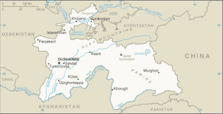
Tajikistan is nestled between Kyrgyzstan and Uzbekistan to the north and west, China to the east, and Afghanistan to the south. Mountains cover 93 percent of Tajikistan's surface area. The two principal ranges, the Pamir Mountains and the Alay Mountains, give rise to many glacier-fed streams and rivers, which have been used to irrigate farmlands since ancient times. Central Asia's other major mountain range, the Tian Shan, skirts northern Tajikistan. Mountainous terrain separates Tajikistan's two population centers, which are in the lowlands of the southern and northern sections of the country. Especially in areas of intensive agricultural and industrial activity, the Soviet Union's natural resource utilization policies left independent Tajikistan with a legacy of environmental problems.
Turkmenistan is a landlocked country in Central Asia, bordering the Caspian Sea to the west, Iran and Afghanistan to the south, Uzbekistan to the north-east, and Kazakhstan to the north-west. It is the southernmost republic of the Commonwealth of Independent States (CIS), the loose federation created at the end of 1991 by most of the Post-Soviet states.
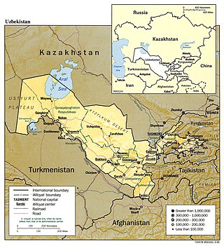
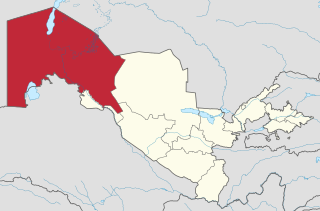
Uzbekistan is a country of Central Asia, located north of Turkmenistan and Afghanistan. With an area of 447,000 square kilometers, Uzbekistan stretches 1,425 km (885 mi) from west to east and 930 km (580 mi) from north to south. It borders Turkmenistan to the southwest, Kazakhstan to the north, and Tajikistan and Kyrgyzstan to the south and east. Uzbekistan also has four small exclaves in Turkmenistan.

The Aral Sea was an endorheic lake lying between Kazakhstan in the north and Uzbekistan in the south which began shrinking in the 1960s and had largely dried up by the 2010s. The name roughly translates as "Sea of Islands", referring to over 1,100 islands that had dotted its waters. In the Mongolic and Turkic languages, aral means "island, archipelago". The Aral Sea drainage basin encompasses Uzbekistan and parts of Tajikistan, Turkmenistan, Kyrgyzstan, Kazakhstan, Afghanistan, and Iran.

The Karakum Desert, also spelled Kara-Kum and Gara-Gum, is a desert in Central Asia. Its name in Turkic languages means "black sand": "kum" means sand; "kara" is a contraction of garaňky: "dark" or may pre-date that in this language family. This refers to the shale-rich sand generally beneath the sand of much of the desert. It occupies about 70 percent, 350,000 km2 (140,000 sq mi), of Turkmenistan.
Karakalpakstan, officially the Republic of Karakalpakstan, is an autonomous republic of Uzbekistan. It occupies the whole northwestern part of Uzbekistan. The capital is Nukus. The Republic of Karakalpakstan has an area of 166,590 km2 (64,320 sq mi), and a population of about two million. Its territory covers the classical land of Khwarezm, which in classical Persian literature was known as Kāt (کات).

Lake Balkhash is a lake in southeastern Kazakhstan, one of the largest lakes in Asia and the 15th largest in the world. It is located in the eastern part of Central Asia and sits in the Balkhash-Alakol Basin, an endorheic (closed) basin. The basin drains seven rivers, the primary of which is the Ili, bringing most of the riparian inflow; others, such as the Karatal, bring surface and subsurface flow. The Ili is fed by precipitation, largely vernal snowmelt, from the mountains of China's Xinjiang region.

Moʻynoq, also spelled as Muynak and Moynaq, is a city in northern Karakalpakstan, an autonomous republic in Uzbekistan. It is the seat of the Moʻynoq District. Formerly a sea port on the Aral Sea, it is now 150 km from the water in the Aralkum Desert and thus is a disaster tourism destination. It is also the location for the biggest electronic music festival in Central Asia.

Aral, also known as Aralsk or Aral'sk, is a small city in south-western Kazakhstan, located in the oblast (region) of Kyzylorda. It serves as the administrative center of Aral District. Aral was formerly a fishing port and harbour city on the banks of the Aral Sea, and was a major supplier of fish to the neighboring region. Population: 29,987 ; 30,347.

The Caspian Depression or Pricaspian/Peri-Caspian Depression/Lowland is a low-lying flatland region encompassing the northern part of the Caspian Sea, the largest enclosed body of water on Earth. It is the larger northern part of the wider Aral-Caspian Depression around the Aral and Caspian Seas.
Kazakhstan, has serious environmental issues such as radiation from nuclear testing sites, the shrinking of the Aral sea, and desertification of former agricultural land. These issues are due in large part to Kazakhstan's years under the Soviet Union.
Environmental issues in Tajikistan include concentrations of agricultural chemicals and salts in the soil and groundwater, poor management of water resources, and soil erosion. Additionally, because of inadequate sanitation facilities, untreated industrial waste and sewage combine with agricultural runoff to cause water pollution in the Aral Sea Basin. Soviet-Era mining operations in Tajikistan extracted and processed uranium, gold, antimony, tungsten, mercury, and molybdenum, each of which is known to leave toxic waste that also threatens water quality. Pockets of high air pollution caused by industry and motor vehicles have resulted in Tajikistan ranking 133rd in the world in greenhouse gas emissions. Air pollution is a particular problem during times of the year when atmospheric conditions hold industrial and vehicle emissions close to the surface in urban areas. In summer, dust and sand from the deserts of Uzbekistan and Turkmenistan cause air pollution across the entire southwestern lowland region.
Environmental issues in Turkmenistan are most visible in three significant areas: desertification, the drying of the Aral Sea, and chemical pollution. All three of these areas are directly linked to agricultural practices in the country.

The northern three-toed jerboa is a species of rodent in the family Dipodidae. It is the only extant species within the genus Dipus. It ranges across Iran, Uzbekistan, Turkmenistan, Kazakhstan, Russia, China and Mongolia. A common species, the International Union for Conservation of Nature rates it as being of "least concern".
After irrigation projects diverted water from the Aral Sea it began to dry up and left behind salts, other minerals, and toxins in the soil. These not only contaminated the soil but also were picked up by winds and storms, and traveled to other areas, including over crop lands. This has led to increased health problems like respiratory diseases and cancers, among others. The change in the size of the Aral has also affected the local climate and resulted in increased occurrence and worsening of storms.
Delta Blues is a 2001 documentary film. The movie deals with the environmental problems emanating from the drying up of the Aral Sea, and the impact this has on political relationships in the Central Asian region. In particular, it focuses on the document Water-related vision for the Aral Sea basin for the year 2025 by UNESCO, as presented in 2000 at the 2nd World Water Forum in The Hague. This document has been criticized for setting unrealistic goals, and also, by focusing on the entire basin, for implicitly giving up on the Aral Sea and the people living downstream in Karakalpakstan.
Almagul Menlibayeva is a Kazakhstani artist and curator who splits her time between Kazakhstan and Germany. Her art's main themes revolve around social and ecological issues in Central Asia.