The Tian Shan is sacred in Tengrism. Its second-highest peak is known as Khan Tengri, which can be translated as "Lord of the Spirits".[4] At the 2013 Conference on World Heritage, the eastern portion of Tian Shan in western China's Xinjiang Region was listed as a World Heritage Site.[5] The western portion in Kazakhstan, Kyrgyzstan, and Uzbekistan was then listed in 2016.[6]
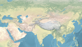
The Tian Shan range extends eastwards for approximately 2,900 kilometers from Tashkent, Uzbekistan.[3] It forms part of the Himalayanorogenic belt, resulting from the collision of the Indian and Eurasian tectonic plates during the Cenozoic era. The range encompasses the Bogda Shan in the east, as defined by both Western and Chinese cartography.
The Torugart Pass, at 3,752 metres (12,310ft), marks the border between Kyrgyzstan and Xinjiang. The lower-altitude, forested Alatau ranges in the northern Tian Shan is home to Turkic-speaking pastoral tribes.
Continuous permafrost typically forms in the Tian Shan at elevations above 3,500-3,700 meters. Discontinuous permafrost can be found as low as 2,000 meters in specific locations influenced by unique topographical and climatic conditions, though it generally occurs between 2,700-3,300 meters altitude.[7]
The Tian Shan's glaciers are rapidly receding, losing 27% or 5.4 billion tons of ice annually since 1961— nearly four times the global average of 7%. By 2050, half of the remaining ice is projected to disappear.[8]
Russian explorer Peter Semenov was one of the first Europeans to extensively document the Tian Shan in the 1850s.
Terskey Alatoo (Terskey Alatau, Terskej Alatau, Teskey Alatoo) and
Trans-Ili Alatau (Ile Alatau, Ile Alatauy, Zailiisky Alatau, Transili Alatau).
In China the Tian Shan starts from about 600 to 400 kilometres (370 to 250mi) east of Ürümqi, north of Kumul City (Hami) with the Qarlik Tagh and the Barkol Mountains. Then the Bogda Shan (god mountains) run from 350 to 40 kilometres (217 to 25mi) east of Ürümqi. Then there is a low area between Ürümqi and the Turfan Depression. The Borohoro Mountains start just south of Ürümqi and run west-northwest 450 kilometres (280mi) separating Dzungaria from the Ili River basin. Their north end abuts on the 200 kilometres (120mi)Dzungarian Alatau which runs east northeast along Sino-Kazakh border. They start 50 kilometres (31mi) east of Taldykorgan in Kazakhstan and end at the Dzungarian Gate. The Dzungarian Alatau in the north, the Borohoro Mountains in the middle and the Ketmen Ridge in the south make a reversed Z or S, the northeast enclosing part of Dzungaria and the southwest enclosing the upper Ili valley.
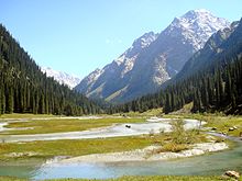
Map of Kyrgyzstan (borders marked in red). The Tian Shan makes up large parts of southern Kyrgyzstan. The indentation on the west is the Fergana ValleyMap of Tian ShanTian Shan as viewed from the Karakol valley (Issyk-Kul Region, Kyrgyzstan)Snow-capped peaks of the Tian Shan seen from an Issyk Kul Lake beach
In Kyrgyzstan the mainline of the Tian Shan continues as Narat Range from the base of the Borohoros west 570 kilometres (350mi) to the point where China, Kazakhstan, and Kyrgyzstan meet. Here is the highest part of the range – the Central Tian Shan, with Peak Pobeda (Kakshaal Too range) and Khan Tengri. West of this, the Tian Shan split into an 'eye', with Issyk Kul Lake in its center. The south side of the lake is the Terskey Alatau and the north side the Kyungey Ala-Too (shady and sunny Ala-Too). North of the Kyungey Ala-Too and parallel to it is the Trans-Ili Alatau in Kazakhstan just south of Almaty. West of the eye, the range continues 400 kilometres (250mi) as the Kyrgyz Ala-Too, separating Chüy Region from Naryn Region and then Kazakhstan from the upper valley of the river Talas, the south side of which is the 200 kilometres (120mi)Talas Ala-Too Range ('Ala-too' is a Kyrgyz spelling of Alatau). At the east end of the Talas Alatau the Suusamyr Too range runs southeast enclosing the Suusamyr Valley or plateau.
As for the area south of the Fergana Valley there is an 800 kilometres (500mi) group of mountains that curves west-southwest from south of Issyk Kul Lake separating the Tarim Basin from the Fergana Valley. The Fergana Range runs northeast towards the Talas Ala-Too and separates the upper Naryn basin from Fergana proper. The southern side of these mountains merge into the Pamirs in Tajikistan (Alay Mountains and Trans-Alay Range). West of this is the Turkestan Range, which continues almost to Samarkand.
Ice Age
The Tian Shan plateau, stretching 100 to 120km wide, is located on the northern margin of the Tarim basin between the Kokshaal-Tau mountain chain to the south and the Terskey Alatau mountain chain to the north. The Kokshaal-Tau extends for 570km from Pik Dankowa in the west to Pik Pobeda in the east-northeast. This mountain chain, along with the parallel Terskey Alatau and the Tian Shan plateau in between, were covered by connected ice-stream-networks and a plateau glacier during glacial times. The only remaining interglacial remnant of this glaciation is the 61km long South Inylschek glacier. The outlet glacier tongues of the plateau glacier flowed northward down to Lake Issyk Kul, calving in this 160km long lake.
Similarly, strong glaciation was present in the high mountain area of the Kungey Alatau, which stretches for 230km north of Issyk Kul and connects to the mountain foreland near Alma Ata. The glacial glaciers from the Kungey Alatau also calved into Lake Issyk Kul, with the Ak-Sai valley glacier developing a mountain foreland glacier.[9][10][11] The Chon-Kemin valley was glaciated up to its inflow into the Chu valley.[9][12][11]
Altogether, the glacial Tian Shan glaciation occupied an area of approximately 118,000 square kilometers. The glacier snowline was about 1200m lower during the last ice age than it is today. This would result in a depression of the average annual temperature of 7.2 to 8.4°C for the Last Glacial Maximum compared with today, assuming a comparable precipitation ratio.[9]
The Tian Shan holds important forests of Schrenk's spruce (Picea schrenkiana) at altitudes of over 2,000 metres (6,600ft); the lower slopes have unique natural forests of wild walnuts and apples.[13]
The Tian Shan in its immediate geological past was kept from glaciation due to the "protecting" warm influence of the Indian Oceanmonsoon climate. This defined its ecological features which could sustain its distinctive ecosphere. The mountains were subjected to constant geological changes with constantly evolving drainage systems which affected the patterns of vegetation, as well as exposing fertile soil for newly emerging seedlings to thrive in.
Tulips originated in the Tian Shan Mountains. The plant then made its way to Turkey via the Silk Road and became a symbol of the Ottoman Empire.[14]
Ancestors of important crop vegetation were established and thrived in the area, among them: apricots (Prunus armeniaca), pears (Pyrus spp.), pomegranates (Punica granatum), figs (Ficus), cherries (Prunus avium) and mulberries (Morus). The Tian Shan region also included important animals like bears, deer, and wild boar, which helped to spread seeds and expand ecological diversity.
Among the vegetation colonizing the Tian Shan came, likely via birds from the east, the ancestors of what we know as the "sweet" apple. The fruit probably then looked like a tiny, long-stalked, bitter apple something like Malus baccata, the Siberian crab. The pips may have been carried in a bird's crop or clotted onto feet or feathers.
What natural features of the unique Tian Shan might have contributed to this rigorous selection program? Time is, as we have seen, not a problem. The turnover of individual trees is likewise conducive to the rapid evolution of a tree species, as is the fact that sweet apples are now, at least for all practical purposes, self-incompatible—that is, they cannot pollinate themselves. Therefore each apple tree within the forest and even each pip, usually five, within each individual fruit will be different. There are many apples on a mature tree, so natural selection has a rich and diverse population upon which to work. Birds, of course, eat all manner of fruit. But most birds eat seeds—a dietary feature not conducive either to the selection or spread of a fruit tree. Sweet apples are often eviscerated by birds, but the seeds are frequently left in the empty shell of the pome. The reason is that apple (and pear and quince) seeds are rich in cyanoglycosides, which are highly repellent, particularly to birds... Moreover, the placenta of the apple fruit, the womb, contains inhibitory substances that prevent the germination of the apple seed in situ. This is a commonly observed phenomenon in fruits as Michael Evenari showed in 1949. So what then does, or did, distribute the original apple seed? The bear...
The strain of Y. pestis which caused the bubonic plague now know as the Black Death may have originated in the Tian Shan, spreading along the Silk Road and killing half of Europe's population in the mid 1300s.[16]
In Tengrism, Khan Tengri, is the lord of all spirits and the religion's supreme deity, and it is the name given to the second highest peak of Tian Shan.[4]
Name
One of the earliest historical references to these mountains may be related to the Xiongnu word Qilian (traditional Chinese:祁連; simplified Chinese:祁连; pinyin:Qílián), which, according to Tang commentator Yan Shigu, is the Xiongnu word for "sky" or "heaven".[20]Sima Qian, in the Records of the Grand Historian, mentioned Qilian in relation to the homeland of the Yuezhi, and the term is believed to refer to the Tian Shan rather than the range 1,500 kilometres (930mi) further east now known as the Qilian Mountains.[21][22] The name of the Tannu-Ola mountains in Tuva has the same meaning. The Chinese name Tian Shan is most likely a direct translation of the traditional Kyrgyz name for the mountains, Teñir Too.[1]
1 2 3 Scheffel, Richard L.; Wernet, Susan J., eds. (1980). Natural Wonders of the World. USA: Reader's Digest Association, Inc. p.378. ISBN978-0-89577-087-5.
↑ "Western Tien-Shan". UNESCO World Heritage Centre. United Nations Educational, Scientific and Cultural Organization. Archived from the original on 7 July 2018. Retrieved 17 July 2016.
↑ Gorbunov, A.P. (1993), "Geocryology in Mt. Tianshan", PERMAFROST: Sixth International Conference. Proceedings. July 5–9, Beijing, China, vol.2, South China University of Technology Press, pp.1105–1107, ISBN978-7-5623-0484-5
1 2 3 Kuhle, M. (1994). "New Findings on the Ice-cover between Issyk-Kul and K2 (Tian Shan, Karakorum) during the Last Glaciation". In Zheng Du; Zhang Qingsong; Pan Yusheng (eds.). Proceedings of the International Symposium on the Karakorum and Kunlun Mountains (ISKKM), Kashi, China, June 1992. Beijing: China Meteorological Press. pp.185–197. ISBN7-5029-1800-0.
↑ Kuhle, M.; Schröder, N. (2000). "New Investigations and Results on the Maximum Glaciation of the Kirgisen Shan and Tian Shan Plateau between Kokshaal Tau and Terskey Alatau". In Zech, W. (ed.). Pamir and Tian Shan. Contribution of the Quaternary History. International Workshop at the University of Bayreuth. Bayreuth, University Bayreuth. p.8.{{cite book}}: CS1 maint: location missing publisher (link)
1 2 Kuhle, M. (2004). "The High Glacial (Last Ice Age and LGM) glacier cover in High- and Central Asia. Accompanying text to the mapwork in hand with detailed references to the literature of the underlying empirical investigations". In Ehlers, J.; Gibbard, P. L. (eds.). Quaternary Glaciations - Extent and Chronology. Vol.3. Amsterdam: Elsevier. pp.175–199. ISBN0-444-51462-7.
↑ Great Courses: 'The Botanist's Eye'(DVD 2 chapter 7) by Catherine Kleier, PhD from California Polytechnic State University.
↑ Juniper, Barrie E. (2007). "The Mysterious Origin of the Sweet Apple: On its way to a grocery counter near you, this delicious fruit traversed continents and mastered coevolution". American Scientist. 95 (1): 44–51. doi:10.1511/2007.63.44. JSTOR27858899.
↑ 班固 (2015-08-20). 漢書: 顏師古註 Hanshu: Yan Shigu Commentary. Archived from the original on 2023-01-14. Retrieved 2016-09-10. 祁連山即天山也,匈奴呼天為祁連 (translation: Qilian Mountain is the Tian Shan, the Xiongnu called the sky qilian)
This page is based on this Wikipedia article Text is available under the CC BY-SA 4.0 license; additional terms may apply. Images, videos and audio are available under their respective licenses.