The Hmu language, also known as Qiandong Miao, Central Miao (中部苗语), East Hmongic, or Black Miao, is a dialect cluster of Hmongic languages of China. The best studied dialect is that of Yǎnghāo (养蒿) village, Taijiang County, Guizhou Province.
Loushan Pass (忆秦娥·娄山关) is a ci poem written by Mao Zedong in February, 1935, during the Long March. Loushan Pass itself is a gorge among mountains in Guizhou province, China. Mao wrote this poem after the Red Army defeated the local government army after a fierce battle and occupation the pass.

The Wuling Mountains are a mountain range located in Central China, running from Chongqing Municipality and East Guizhou to West Hunan. They are home to many ethnic groups, including as the Tujia, Han, Miao, Dong, and Bai.

Hechi is a prefecture-level city in the northwest of the Guangxi Zhuang Autonomous Region, People's Republic of China, bordering Guizhou to the north. The actual inner city itself is referred as Jinchengjiang. In June 2002 it gained city status.

Ouhai District is a district of Wenzhou, Zhejiang. It is an outlying district of Wenzhou urban area.

The Yunnan–Guizhou Plateau or Yungui Plateau is a highland region located in southwest China. The region is primarily spread over the provinces of Yunnan and Guizhou. In the southwest, the Yungui is a true plateau with relatively flatter highland areas, while in the northeast, the Yungui is a generally mountainous area of rolling hills, gorges, and karst topography.
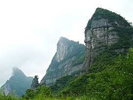
The Fanjingshan or Mount Fanjing, located in Tongren, Guizhou province, is the highest peak of the Wuling Mountains in southeastern China, at an elevation of 2,570 m (8,430 ft). The Fanjingshan National Nature Reserve was established in 1978 and designated a UNESCO Biosphere Reserve in 1986. Fanjingshan is a sacred mountain in Chinese Buddhism, considered to be the bodhimaṇḍa of the Maitreya Buddha. It became a UNESCO World Heritage Site in 2018.

Bijie is a prefecture-level city in northwestern Guizhou Province, China, bordering Sichuan to the north and Yunnan to the west.
Boluo County is a county of east-central Guangdong province, People's Republic of China. It is under the administration of the prefecture-level city of Huizhou, and in 2009, had a population of 813,700 residing in an area of 2,795 km2 (1,079 sq mi). It borders Yuancheng District, Dongyuan and Zijin counties to the northeast, Huiyang and Huicheng Districts to the southeast, Dongguan to the south, Zengcheng to the west, and Longmen County to the northwest.
Louxing District is the only urban district and the seat of Loudi Prefecturel-level City, Hunan Province, China.
Shuangfeng County is a county in Hunan Province, China, it is under the administration of Loudi prefecture-level City.
Jinping County is a county in the east of Guizhou province, China, bordering Hunan to the east. It is under the administration of the Qiandongnan Miao and Dong Autonomous Prefecture.
Luobohe Miao, also known as Hmjo or A-Hmyo, is a Miao language of China.

Chongqing–Guiyang railway is a major trunk higher-speed rail selected for construction under the 11th Five Year Plan set by the Chinese Government. Construction started on December 22, 2010, and opened on January 25, 2018.
Dabuqiao Subdistrict is a subdistrict in Louxing District of Loudi City, Hunan Province, People's Republic of China.
Shuangjiang Township is a rural township in Louxing District of Loudi City, Hunan Province, People's Republic of China. As of the 2015 census it had a population of 17,000 and an area of 63-square-kilometre (24 sq mi).

Lóu is the pinyin romanization of the Chinese surname written 娄 in simplified character and 婁 in traditional character. It is the 229th most common surname in China, shared by approximately 350,000 people. Lou 娄 is listed 139th in the Song dynasty classic text Hundred Family Surnames.
The Hohhot–Nanning corridor is a proposed high-speed railway in China running from Hohhot in Inner Mongolia to Nanning in Guangxi. It will pass through the cities of Taiyuan, Zhengzhou, Xiangyang, Changde, Yiyang, Shaoyang, Yongzhou and Guilin. The corridor is one of the sixteen railway lines proposed under the "eight horizontal and eight vertical" railway network introduced in 2016.