Zhejiang is an eastern coastal province of the People's Republic of China. Its capital and largest city is Hangzhou, and other notable cities include Ningbo and Wenzhou. Zhejiang is bordered by Jiangsu and Shanghai to the north, Anhui to the northwest, Jiangxi to the west and Fujian to the south. To the east is the East China Sea, beyond which lies the Ryukyu Islands. The population of Zhejiang stands at 64.6 million, the 8th largest in China. It has been called "the backbone of China" because it is a major driving force in the Chinese economy and being the birthplace of several notable people, including the Chinese Nationalist leader Chiang Kai-shek and entrepreneur Jack Ma. Zhejiang consists of 90 counties.

Wenzhou, historically known as Wenchow is a prefecture-level city in China's Zhejiang province. Wenzhou is located at the extreme southeast of Zhejiang, bordering Lishui to the west, Taizhou to the north, and the province of Fujian to the south. The area consists of mostly mountainous terrain, as well as hundreds of islands off the East China Sea coast, which is nearly 355 kilometres in length. It is said that the city's land is 70% mountains, 20% farmland, and 10% water. At the time of the 2010 Chinese census, 3,039,500 people lived in Wenzhou's urban area. The greater Wenzhou prefecture, which also includes three satellite cities and six counties, had a population totalling 9,122,100, of which 31.16% are residents originally from outside of Wenzhou.

Huangshan (Chinese: 黄山), literally meaning the Yellow Mountain(s), is a mountain range in southern Anhui province in eastern China. It was originally called “Yishan”, and it was renamed because of a legend that Emperor Xuanyuan once made alchemy here. Vegetation on the range is thickest below 1,100 meters (3,600 ft), with trees growing up to the treeline at 1,800 meters (5,900 ft).

Lishui is a prefecture-level city in the southwest of Zhejiang province, People's Republic of China. It borders Quzhou, Jinhua and Taizhou to the north, Wenzhou to the southeast, and the province of Fujian to the southwest. The name of the city literally means "Beautiful Waters."

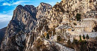
Mount Song is an isolated mountain range in north central China's Henan Province, along the southern bank of the Yellow River. It is known in literary and folk tradition as the central mountain of the Five Great Mountains of China. Since at least as early as the early 1st millennium BC, Chinese astronomical mythology had acquired the idea that Mount Song is "the centre of Heaven and Earth." It was respected as such by the successive dynasties of the Chinese Empire.

Tāizhōu, alternately known as Taichow, is a city located at the middle of the East China Sea coast of Zhejiang province. It is located 300 km (190 mi) south of Shanghai and 230 km (140 mi) southeast of Hangzhou, the provincial capital. It is bordered by Ningbo to the north, Wenzhou to the south, and Shaoxing, Jinhua, and Lishui to west. In addition to the municipality itself, the prefecture-level city of Taizhou includes 3 districts, 3 county-level cities, and 3 counties. As of the 2020 census, its total population was 6,662,888 inhabitants whom 3,578,660 lived in the built-up area made of the three urban Districts and Wenling City now being largely conurbated.

The Wuyi Mountains or Wuyishan are a mountain range located in the prefecture of Nanping, in northern Fujian province near the border with Jiangxi province, China. The highest peak in the area is Mount Huanggang at 2,158 metres (7,080 ft) on the border of Fujian and Jiangxi, making it the highest point of both provinces; the lowest altitudes are around 200 metres (660 ft). Many oolong and black teas are produced in the Wuyi Mountains, including Da Hong Pao and lapsang souchong, and are sold as Wuyi tea. The mountain range is known worldwide for its status as a refugium for several rare and endemic plant species, its dramatic river valleys, and the abundance of important temples and archeological sites in the region, and is a UNESCO World Heritage Site.

Fangshan District is a district of the city of Beijing. It is situated in the southwest of Beijing, 38 km (24 mi) away from downtown Beijing. It has an area of 2,019 square kilometres (780 sq mi) and a population of 814,367. The district is divided into 8 subdistricts, 14 towns, and 6 townships.

Mount Jiuhua located in Chizhou, Anhui Province in China is an important Buddhist site and natural scenic spot. It is one of the four famous Buddhist mountains in China, one of the first batch of 5A level scenic spots in China, one of the first batch of natural and cultural heritage sites in China, and the main scenic spot of "two mountains and one lake" tourism development strategy in Anhui Province. The planned area of the scenic spot is 120 square kilometers, and the protected area is 174 square kilometers, which is composed of 11 scenic spots.
Yueqing is a county-level city under the administration of Wenzhou, Zhejiang Province, in eastern China. It lies on the coast of the East China Sea, by the Yueqing Bay. Much of the Yandang Mountains lie in Yueqing.

Cangnan County is a county in the prefecture-level city of Wenzhou in southern Zhejiang, China. The county government is in Lingxi. Cangnan has 20 towns, 14 townships, and two nationality townships. Cangnan and Taishun are apart of the Min Dong, Eastern Min cultural region of Zhejiang province. Wenzhou dialect and Jinxiang dialect, are also spoken.

Wenling is a coastal county-level city in the municipal region of Taizhou, in southeastern Zhejiang province, China. It borders Luqiao and Huangyan to the north, Yuhuan to the south, Yueqing to the west, looks out to the East China Sea to the east. Wenling locates on 28°22'N, 121°21'E, approximately 300 km (190 mi) south of Shanghai.

Wenzhou Medical University (WMU); Chinese: 温州医科大学; pinyin: Wēnzhōu Yīkē Dàxué), designated as a key university in Wenzhou, Zhejiang, is an institution of higher learning under the leadership of Zhejiang Provincial Government.

The Nanxi River is located in Yongjia County, Wenzhou, Zhejiang Province in eastern China, and is a major tributary of the Ou River.

Tiantai Mountain is a mountain in Tiantai County, Taizhou, Zhejiang Province, China. Its highest peak, Huading, reaches a height of 1,138 meters (3,734 ft). The mountain was made a national park on 1 August 1988. One of nine remaining wild populations of Seven-Son Flower is located on mount Tiantai.

Wuyanling National Nature Reserve is a nature reserve in Taishun County, in the southern part of Zhejiang Province. The reserve occupies a mountainous, forested area. The highest peak is Baiyun Peak, which is 1,611 metres (5,285 ft) high.
The Port of Taizhou is a natural seaport on the coast of the prefectural-level city of Taizhou, Zhejiang Province, People's Republic of China. The Port is centered at the mouth of the Jiaojiang River, with port areas opening to the Taizhou Bay, Yueqing Bay and Sanmen Bay of the East China Sea. It is considered as the southernmost of the ports of the Yangtze Delta economic area. In 2013 it reached a throughput of 56.28 million metric tons, an increase of 5.0% over 2012, and a container throughput of 166,571 TEUs, an increase of 10.4%.

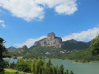
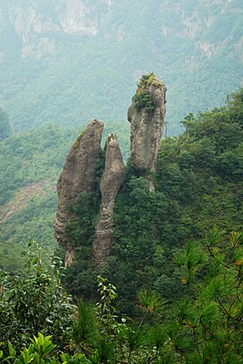
Middle Yandang Mountains or Zhong Yandang Shan refers, in the broad sense, to a coastal mountain range in southeastern Zhejiang Province in eastern China, which is close to Yandang Mountains, and both of them are parts of Yandang Ridge. It is said that people found that there was a lake in the top of the mountain, which was covered with reeds. And many wild geese lived there. Therefore, it is called "Yandang". It is historically called "the Best Mountain in Southeastern China". Comparing to Yandang Mountains, it seems like a religious interest rather than a geographic interest, which does not mean that Yandang Mountains are much better than Middle Yandang Mountains when it comes to natural landscape, but the latter is unique because of the religion. With cool climate and convenient traffic, as well as palatable sea food, it has been affirmed as one of the best ten summer resort in Zhejiang Province. It is said a Taoist priest, who believed in Taoism, came here and built a temple.

China National Highway 228 (228国道) is a planned highway of the National Highway System of the People's Republic of China to run from Dandong, Liaoning on the China–North Korea border to Dongxing, Guangxi on the China–Vietnam border.

Taizhou Rail Transit, are two systems of commuter railway, one of which effectively works as a metro system in Taizhou, Zhejiang province, China. The system is operated by Taizhou Rail Transit Construction and Development Co., Ltd. In the near term, two lines, S1 and S2, are planned; in the long term, lines S3 and S4 are planned. The first phase of the plan was approved by the National Development and Reform Commission of the People's Republic of China in December 2014, and approved by the Zhejiang Provincial Development and Reform Commission in September 2016. Construction of Line S1 started in November 2016 and lasted until opening in December 2022.


