You can help expand this article with text translated from the corresponding article in French. (November 2024)Click [show] for important translation instructions.
View a machine-translated version of the French article.
Machine translation, like DeepL or Google Translate, is a useful starting point for translations, but translators must revise errors as necessary and confirm that the translation is accurate, rather than simply copy-pasting machine-translated text into the English Wikipedia.
Do not translate text that appears unreliable or low-quality. If possible, verify the text with references provided in the foreign-language article.
You must provide copyright attribution in the edit summary accompanying your translation by providing an interlanguage link to the source of your translation. A model attribution edit summary is Content in this edit is translated from the existing French Wikipedia article at [[:fr:Pamir]]; see its history for attribution.
You may also add the template {{Translated|fr|Pamir}} to the talk page.
The Pamir Mountains are a range of mountains between Central Asia and South Asia. They are located at a junction with other notable mountains, namely the Tian Shan, the Karakoram, the Kunlun, the Hindu Kush, and the Himalayas. They are among the world's highest mountains.
Pamir as seen from the map, as well as the Amu Darya river which rises from the Pamir Mountains north of the Hindu Kush and the Helmand River which is the longest river in the entire country of Afghanistan.
The Pamir region is home to several different cultures, peoples and languages. In some of these languages, the Pamir Mountains are referred by different names.
According to Middleton and Thomas, "pamir" is also a geological term.[7] A pamir is a flat plateau or U-shaped valley surrounded by mountains. It forms when a glacier or ice field melts leaving a rocky plain. A pamir lasts until erosion forms soil and cuts down normal valleys. This type of terrain is found in the east and north of the Wakhan,[8] and the east and south of Gorno-Badakhshan, as opposed to the valleys and gorges of the west. Pamirs are used for summer pasture.[7][8]
Slopes of Pamir Mountains on the Chinese side and Muztagh Ata
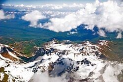
Pamir Mountains from a NASA satellite image, April 2012
Mountain
The three highest mountains in the Pamirs core are Ismoil Somoni Peak (known from 1932 to 1962 as Stalin Peak, and from 1962 to 1998 as Communism Peak), 7,495m (24,590ft); Ibn Sina Peak (still unofficially known as Lenin Peak), 7,134m (23,406ft); and Peak Korzhenevskaya (Russian: Пик Корженевская, Pik Korzhenevskoi), 7,105m (23,310ft).[9] In the Eastern Pamirs, China's Kongur Tagh is the highest at 7,649m (25,095ft).
Among the significant peaks of the Pamir Mountains are the following:[10]
Remark: The summits of the Kongur and Muztagata Group are in some sources counted as part of the Kunlun, which would make Pik Ismoil Somoni the highest summit of the Pamir.
Pamir Mountains from an airplane
Glaciers
There are many glaciers in the Pamir Mountains, including the 77km (48mi) long Vanch-Yakh Glacier, the longest in the former USSR and the longest glacier outside the polar regions.[11] Approximately 12,500km2 (ca. 10%)[12] of the Pamirs are glaciated. Glaciers in the Southern Pamirs are retreating rapidly. Ten percent of annual runoff is supposed to originate from retreating glaciers in the Southern Pamirs.[12] In the North-Western Pamirs, glaciers have almost stable mass balances.[12]
The East-Pamir, in the centre of which the massifs of Mustagh Ata (7620 m) and Kongur Tagh (Qungur Shan, 7578, 7628 or 7830 m) are situated, shows from the western margin of the Tarim Basin an east–west extension of c. 200km. Its north–south extension from King Ata Tagh up to the northwest Kunlun foothills amounts to c.170km. Whilst the up to 21km long current valley glaciers are restricted to mountain massifs exceeding 5600 m in height, during the last glacial period the glacier ice covered the high plateau with its set-up highland relief, continuing west of Mustagh Ata and Kongur. From this glacier area an outlet glacier has flowed down to the north-east through the Gez valley up to c.1850masl (meters above sea level) and thus as far as to the margin of the Tarim basin. This outlet glacier received inflow from the Kaiayayilak glacier from the Kongur north flank. From the north-adjacent Kara Bak Tor (Chakragil, c. 6800 or 6694 m) massif, the Oytag valley glacier in the same exposition flowed also down up to c. 1850masl. At glacial times the glacier snowline (ELA[B]) as altitude limit between glacier nourishing area and ablation zone, was about 820 to 1250 metres lower than it is today.[14][15] Under the condition of comparable proportions of precipitation there results from this a glacial depression of temperature of at least 5 to 7.5°C.
Economy
Coal is mined in the west, though sheep herding in upper meadowlands is the primary source of income for the region.
Exploration
Expedition in 1982 to Tartu Ülikool 350 Peak, which was considered to be the highest unreached peak in the territory of former Soviet Union at the time.
The lapis lazuli found in Egyptian tombs is thought to come from the Pamir area in Badakhshan province of Afghanistan.[7] About 138 BCE Zhang Qian reached the Fergana Valley northwest of the Pamirs. Ptolemy vaguely describes a trade route through the area. From about 600 CE, Buddhist pilgrims travelled on both sides of the Pamirs to reach India from China. In 747 a Tang army was on the Wakhan River. There are various Arab and Chinese reports. Marco Polo may have travelled along the Panj River. In 1602, Bento de Goes travelled from Kabul to Yarkand and left a meager report on the Pamirs. In 1838, Lieutenant John Wood reached the headwaters of the Pamir River. From about 1868 to 1880, a number of Indians in the British service secretly explored the Panj area. In 1873, the British and Russians agreed to an Afghan frontier along the Panj River. From 1871 to around 1893, several Russian military-scientific expeditions mapped out most of the Pamirs (Alexei Pavlovich Fedchenko, Nikolai Severtzov, Captain Dmitry Putyata and others. Later came Nikolai Korzhenevskiy). Several local groups asked for Russian protection from Afghan raiders. The Russians were followed by a number of non-Russians including Ney Elias, George Littledale, the Earl of Dunmore, Wilhelm Filchner and Lord Curzon who was probably the first to reach the Wakhan source of the Oxus River. In 1891, the Russians informed Francis Younghusband that he was on their territory and later escorted a Lieutenant Davidson out of the area ('Pamir Incident'). In 1892, a battalion of Russians under Mikhail Ionov entered the area and camped near the present Murghab. In 1893 they built a proper fort there (Pamirskiy Post). In 1895 their base was moved to Khorog facing the Afghans.
In the early 1980s, a deposit of gemstone-quality clinohumite was discovered in the Pamir Mountains. It was the only such deposit known until the discovery of gem-quality material in the Taymyr region of Siberia, in 2000.
In December 2009, the New York Times featured articles on the possibilities for tourism in the Pamir area of Tajikistan.[18][19] 2013 proved to be the most successful year ever for tourism in the region and tourism development continues to be the fastest growing economic sector.
Strategic position
Climbers near "Peak Communism" in 1978.
Historically, the Pamir Mountains were considered a strategic trade route between Kashgar and Kokand on the Northern Silk Road, a prehistoric trackway, and have been subject to numerous territorial conquests. The Northern Silk Road (about 2,600km (1,616mi) in length) connected the ancient Chinese capital Chang'an with Kashgar over the Pamir Mountains towards the west, and from there continued to ancient Parthia.[20] In the 20th century, these mountains have been the setting for the Tajikistan Civil War, border disputes between China and the Soviet Union, establishment of military bases by the US, Russia, and India,[21] and renewed interest in trade development and resource exploration.[22][23] The Chinese government says it has resolved most of the disputes it had with Central Asian countries.[24]
↑The snow line that separates the snow above from the firn (1 yr old snow) or bare glacier ice below is the equilibrium line altitude (ELA).[13]
References
↑According to the Big Soviet Encyclopedia "The question of the natural boundaries of Pamir is debatable. Normally Pamir is regarded as covering the territory from Trans-Alay Range to the north, Sarykol Range to the east, Lake Zorkul, Pamir River, and the upper reaches of Panj River to the south, and the meridional section of the Panj valley to the west; to the north-west Pamir includes the eastern parts of Peter the Great and Darvaz ranges."
↑Arnaud, N. O.; Brunel, M.; Cantagrel, J. M.; Tapponnier, P. (1993). "High cooling and denudation rates at Kongur Shan, Eastern Pamir (Xinjiang, China)". Tectonics. 12 (3): 1335–1346. doi:10.1029/93TC00767.
↑Li, Daoyuan. 水經注[Commentary on the Water Classic] (in Chinese). Vol.2 – via Wikisource. 蔥嶺在敦煌西八千里,其山高大,上生蔥,故曰蔥嶺也。(quoting from the "西河舊事") The Onion Range is 8,000 Li west of Dunhuangin Uzbek Language "Pamir Tog'i". Its mountains are high and onions grow on them, therefore it is called Onion Range.
123This section is based on the book by R. Middleton and H. Thomas: Robert Middleton and Huw Thomas, 'Tajikistan and the High Pamirs', Odyssey Books, 2008
↑Tajikistan: 15 Years of Independence, statistical yearbook, Dushanbe, 2006, p. 8, in Russian.
↑"Dominance". www.8000ers.com. Retrieved 6 April 2010.
↑In the Karakoram Mountains, Siachen Glacier is 76 km long, Biafo Glacier is 67 km long, and Baltoro is 63 km long. The Bruggen or Pio XI Glacier in southern Chile is 66 km long. Kyrgyzstan's South Inylchek (Enylchek) Glacier is 60.5km in length. Measurements are from recent imagery, generally with Russian 1:200,000 scale topographic mapping for reference as well as the 1990 Orographic Sketch Map: Karakoram: Sheets 1 and 2, Swiss Foundation for Alpine Research, Zurich.
↑Kuhle, M. (1997):New findings concerning the Ice Age (LGM) glacier cover of the East Pamir, of the Nanga Parbat up to the Central Himalaya and of Tibet, as well as the Age of the Tibetan Inland Ice. Tibet and High Asia (IV). Results of Investigations into High Mountain Geomorphology. Paleo-Glaciology and Climatology of the Pleistocene. GeoJournal, 42, (2–3), pp. 87–257.
↑Kuhle, M. (2004):The High Glacial (Last Ice Age and LGM) glacier cover in High- and Central Asia. Accompanying text to the mapwork in hand with detailed references to the literature of the underlying empirical investigations. Ehlers, J., Gibbard, P. L. (Eds.). Extent and Chronology of Glaciations, Vol. 3 (Latin America, Asia, Africa, Australia, Antarctica). Amsterdam, Elsevier B.V., pp. 175–199.
↑George Nathaniel Curzon; The Hindu World: An Encyclopedic Survey of Hinduism, 1968, p 184
↑Benjamin Walker - Hinduism; Ancient Indian Tradition & Mythology: Purāṇas in Translation, 1969, p 56
↑Jagdish Lal Shastri, Arnold Kunst, G. P. Bhatt, Ganesh Vasudeo Tagare - Oriental literature; Journal of the K.R. Cama Oriental Institute, 1928, p 38
↑Bernice Glatzer Rosenthal - History; Geographical Concepts in Ancient India, 1967, p 50
↑Bechan Dube - India; Geographical Data in the Early Purāṇas: A Critical Study, 1972, p 2
↑Dr M. R. Singh - India; Studies in the Proto-history of India, 1971, p 17
↑Gopal, Madan (1990). K.S. Gautam (ed.). India through the ages. Publication Division, Ministry of Information and Broadcasting, Government of India. p.78.
Further reading
Leitner, G. W. (1890). Dardistan in 1866, 1886 and 1893: Being an Account of the History, Religions, Customs, Legends, Fables and Songs of Gilgit, Chilas, Kandia (Gabrial) Yasin, Chitral, Hunza, Nagyr and other parts of the Hindukush. With a supplement to the second edition of The Hunza and Nagyr Handbook. And an Epitome of Part III of the author's "The Languages and Races of Dardistan". First Reprint 1978. Manjusri Publishing House, New Delhi.
Murray, Charles (1894). The Pamirs; being a narrative of a year's expedition on horseback and on foot through Kashmir, western Tibet, Chinese Tartary, and Russian Central Asia. J. Murray. (Vol. I and II)
Wood, John, (1872). A Journey to the Source of the River Oxus. With an essay on the Geography of the Valley of the Oxus by Colonel Henry Yule. London: John Murray.
Gordon, T. E. (1876). The Roof of the World: Being the Narrative of a Journey over the high plateau of Tibet to the Russian Frontier and the Oxus sources on Pamir. Edinburgh. Edmonston and Douglas. Reprint by Ch'eng Wen Publishing Company. Taipei. 1971.
Cobbold, Ralph Patteson (1900). Innermost Asia: travel & sport in the Pamirs. W. Heinemann.
Strong, Anna Louise. (1930). The Road to the Grey Pamir. Robert M. McBride & Co., New York.
Toynbee, Arnold J. (1961). Between Oxus and Jumna. London. Oxford University Press.
Slesser, Malcolm (1964). Red Peak: A Personal Account of the British-Soviet Expedition. Coward McCann.
Wang, Miao (1983). From the Pamirs to Beijing: tracing Marco Polo's northern route. HK China Tourism Press.
Tilman, H. W. (1983). "Two Mountains and a River" part of The Severn Mountain Travel Books. Diadem, London.
Waugh, Daniel C. (1999). "The 'Mysterious and Terrible Karatash Gorges': Notes and Documents on the Explorations by Stein and Skrine." The Geographical Journal, Vol. 165, No. 3. (Nov., 1999), pp. 306–320.
Horsman, S. (2002). Peaks, Politics and Purges: the First Ascent of Pik Stalin in Douglas, E. (ed.) Alpine Journal 2002 (Volume 107), The Alpine Club & Ernest Press, London, pp 199–206.
Gecko-Maps (2004). The Pamirs. 1:500.000 – A tourist map of Gorno-Badkshan-Tajikistan and background information on the region. Verlag "Gecko-Maps", Switzerland ( ISBN3-906593-35-5)
Dagiev, Dagikhudo, and Carole Faucher, eds. (2018). Identity, History and Trans-nationality in Central Asia: The Mountain Communities of Pamir. Routledge.
This page is based on this Wikipedia article Text is available under the CC BY-SA 4.0 license; additional terms may apply. Images, videos and audio are available under their respective licenses.