In 1877, when the first ethnographic works were done under the new imperial Russian administration, Kokand was reported and visually depicted on their maps as Tajik inhabited oasis (C.E de Ujfalvy (“Carte Ethnographique du Ferghanah, 1877”). The city, along with most of the eastern Fergana Valley, was included in the Uzbek Soviet Socialist Republic in the 1920s as part of national delimitation in the Soviet Union.
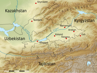
Kokand is at the crossroads of the two main ancient trade routes into the Fergana Valley, one leading northwest over the mountains to Tashkent, and the other west through Khujand. As a result, Kokand is the main transportation junction in the Fergana Valley.
Etymology
The city's name is in conformity with other Central Asian cities that sport the element kand/kent/qand/jand, meaning "a city" in Sogdian as well as other Iranic languages. The Khwarazmian version was kath, which is still found in the name of the old city of Akhsikath/Akhsikat in the Fergana Valley of Uzbekistan. The prefix khu/hu is Iranic might stand "good" (as in modern Tajikkhub), and would therefore translate as "good city". [citation needed]
Another explanation claims a Turkic derivation, and might refer to the "tribal family group of 'Kokan' who belong to the Kongrat tribe of Uzbeks".[3]
History
The town of Kokand is one of the oldest towns in Uzbekistan and is situated in the western part of Fergana Valley. In the chronicles of the 10th century, the first written documents concerning town of Hukande, Havokande (old names of the town). In the 13th century, like most of Central Asian towns, the Mongols ruined the city. The town is a significant hub for trading on the Silk Route.[4]
Kokand has existed since at least the 10th century, under the name of Khavakand, and was frequently mentioned in traveler's accounts of the caravan route between South Asia and East Asia. The Han dynasty of China conquered the entire city in the 1st century BC. Later, the Arabs conquered the region from Tang Empire. The Mongols destroyed Kokand in the 13th century.
The present city began as a fort in 1732 on the site of another older fortress called Eski-Kurgan. In 1740, it became the capital of an Uzbek kingdom, the Khanate of Kokand, which reached as far as Kyzylorda to the west and Bishkek to the northeast. Kokand was also the major religious center of the Fergana Valley, boasting more than 300 mosques.
Imperial forces of Russian Empire under Mikhail Skobelev captured the city in 1883 which then became part of Russian Turkistan. During World War I, two revolutions happened in the Russian Empire. it was the capital of the short-lived (72 days) (1917–18) anti-Bolshevik Provisional Government of Autonomous Turkistan (also known as Kokand Autonomy).[5] They sought co-operation from Ataman Dutov and Alash Orda. However, their emissary to the Amir of Bukhara achieved little.
Archaeological research of Muyi Mubarak, Tepakurgan, Eski Kurgan and other monuments located in the city of Kokand revealed traces of civilization.
In Muyi Mubarak were found several clay shards of the 5th to 6th centuries; a clay platform, which in the 5th to 7th centuries served as the base of a monumental building; the remains of a fortresswall, built in the 1st to 2nd centuries of pahsa and mudbricks, which functioned for more than 400 years. At a depth of 5 meters, a lower cultural layer with materials dating back 2,000 years was discovered.
In Tepakurgan, located in the center of the city, a platform from the Early Middle Ages, which served as the base of a monumental castle with semicircular towers, was discovered, as in Muyi Mubarak.
The obtained artifacts give grounds to say and speculate that not later than the 7th century BC a certain part of the territory of the present city was developed for irrigated agriculture.
And the city appeared not later than the 2nd half of the 2nd century BC and was the center of the Sokh oasis, that is, the capital of the regional possession, which was part of the confederal state of Fergana ("Dayuan" of Chinese annals).
Havokand or Hokand
Arab geographers and travelers of the 10th century, Al-Istakhri and Ibn Haukal mention the city of Khovakand or Khokand, which in distance corresponds to the present Kokand.
According to written sources and local legends, there were ancient cities of Akhsikath, Kubo (Quva), Rishton, Osh, Bab (Pop), Koson (Kashan), Mo-ar-gilon (Margilan), Andigan (Andijan), Uzgen, Isfara, Varukh, Sokh, Konibodom and Khujand in Fergana already at the time of its conquest by Arabs who established Islam here (in the beginning of the 8th century).
Arab travelers of the 10th century mention many other towns and generally notice that, besides towns, there were many large villages in Fergana.
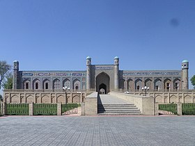
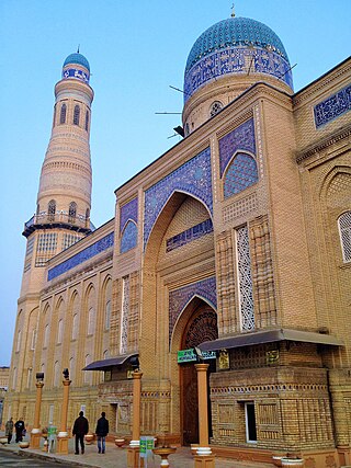
Khudayar Khan commissioned architect Mir Ubaydullo to build him a royal residence with 114 rooms set around seven courtyards.[11] The ruler wanted his mother to live in one of the palace's grand buildings, but she refused and set up her yurt in a courtyard.[10]
The facade of the building is decorated with mosaic tiles and an Arabic inscription above the entrance. The inscription translates as “The High palace of Seid Mohammad Khudayar Khan”.
Most of the palace, including its harem, was demolished by the Soviets, but 19 rooms remain in palace.[10] These are open to the public, and the interiors have been partially restored.[11] They show a combination of Russian and traditional Uzbek styles, and the exquisite craftsmanship of Kokand's 19th-century artisans. It is possible to view the palace's collection of Chinese ceramics on request.[11]
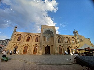
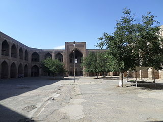
Juma Mosque
Kokand's Juma Mosque (Friday Mosque) is located on Chursu Square in the historic Icheri Sheher part of the city. It was built between 1812 and 1818 by Muhammad Umar Khan, who was ruler of Kokand from 1810 until his death in 1822.
The mosque is built around a large courtyard and has a 100m long iwan supported on 98 redwood columns, which are ornately carved and were brought from India.[11] The minaret is 22m high.[12]
Although intended to be Kokand's main place of worship, the Juma Mosque remained shut for most of the 20th century. It then reopened after much needed restoration in 1989 and now houses a small museum of applied arts with displays of embroideries and ceramics.[12]
Amin Beg Madrassah
The Amin Beg Madrassah, a religious school, was built in the 1830s for a son of Madali Khan, the khan of Kokand from 1822 to 1842. The madrassah has a beautifully tiled facade, which was restored in 1913 by a craftsman called Khomol Khozi. For this reason, the madrassah is often called the Khomol Khozi Madrassah.[13] Today, the building houses a small museum and a shop, but the tiles and the carved wooden columns are still impressive to look at.
Hamza Museum
Built in 1989, the Hamza Museum is named after Hamza Hakimzade Niyazi, a Soviet hero who was born in Kokand. Hamza was Uzbekistan's first national poet and the founder of Uzbek social realism, and the museum was opened to commemorate the centenary of his birth.[13] The museum houses general exhibits about life in Kokand, and also has artefacts relating to a variety of dramatists, propagandists, and writers.[11]
Additional Sites
There are three other historic madrassahs in Kokand. The 19th-century Shaib Mian Hazrat Madrasa has a small museum dedicated to the poet Mohammad Amin Muqimi (1850–1903).[14]
The Narbutabey Madrassah was built in the 1790s. Its graveyard includes the tomb of Muhammad Umar Khan and his wife, the famous Uzbek poet Nodira.[15] Known as the Modari Khan Mausoleum, it is ornately decorated with glazed blue mosaic tiles. Unlike the other madrassahs in Kokand which were closed by the Soviets, the Narbutabey Madrassah remained active as a place of Quranic study until 2016.[13]
The last madrassah is the Dasturkahanchi Madrasa. It was built in 1833 as a school for boys, but it is now a training centre where girls learn embroidery.[15]
Dakhma-I-Shokhon, a necropolis of the Kokand Khans from the 1830.
Education and culture
A number of madrasahs can be found with the city. Kokand made contribution to Islam. It is also home to a number of notable hanafi scholars, such as Abdulhafiz Al-Quqoniy and Yorqinjon Qori Al-Quqoniy.
There are 3 institutes there are "Kokand branch of Tashkent State Technical University(named after Islom Karimov)", "Kokand University(founded in 2019)", "Kokand State Pedagocical Institute", 9 colleges and lyceums, 40 secondary schools, 5 musical schools, a theater, and 20 libraries. There are 7 historical and house museums located in Kokand.[16]
The first International Handicrafters Festival took place in Kokand in September 2019. It was hosted by the Uzbekistan Handicraft Association, and the guest of honour was Rosy Greenlees, President of the World Crafts Council.[17] More than 600 creatives from 70 countries participated.
The festival was created to enable artisans from around the world to demonstrate and sell their products, as well as to network and further develop their skills.[18] The festival included conference sessions dedicated to developing hand craftsmanship.[19] The crafts on display included musical instruments, painting, ceramics, textiles, metalwork, and woodwork.[citation needed]
It is planned that the festival will be a biennial event, and it will next take place in 2021.[20]
Economy
The black market provides nearly 75% of the income generated in the borders of the city.[citation needed] This includes retail, groceries, employment, money exchange, agriculture and manufacturing of many goods. A large part of the population works as small business owners in outdoor markets.
Kokand is a center for the manufacture of fertilizers, chemicals, machinery, and cotton and food products. Over the last two decades, new districts and public buildings have been created in the city as well as many houses, shops, cafes, restaurants and other private sector ventures. Kokand is an education center with one institute, nine colleges and lyceums, and numerous museums.
Mukhtorkhon Tashkhodjaev, Uzbek politician, Chairman of the National Paralympic Committee of Uzbekistan
Related Research Articles
Qarshi is a city in southern Uzbekistan. It is the capital of Qashqadaryo Region. Administratively, Qarshi is a district-level city, that includes the urban-type settlement Qashqadaryo. It has a population of 278,300. It is about 520 km south-southwest of Tashkent, and about 335 km north of Uzbekistan's border with Afghanistan. It is located at latitude 38° 51' 48N; longitude 65° 47' 52E at an altitude of 374 meters. The city is important in natural gas production, but Qarshi is also famous for its production of woven flat carpets.
Fergana Valley is a valley in Central Asia, lying mostly in eastern Uzbekistan, extending into southern Kyrgyzstan and northern Tajikistan.
Khiva is a district-level city of approximately 93,000 people in Khorazm Region, Uzbekistan. According to archaeological data, the city was established around 2,500 years ago. In 1997, Khiva celebrated its 2500th anniversary. It is the former capital of Khwarezmia, the Khanate of Khiva, and the Khorezm People's Soviet Republic. Itchan Kala in Khiva was the first site in Uzbekistan to be inscribed on the World Heritage List (1991). The astronomer, historian and polymath, Al-Biruni was born in either Khiva or the nearby city of Kath.
Andijan, also spelt Andijon and formerly romanized as Andizhan, is a city in Uzbekistan. It is the administrative, economic, and cultural center of Andijan Region. Andijan is a district-level city with an area of 74 km2 (29 sq mi). Andijan is the most densely populated city with density of 10,000 people/km2 and it had 747,800 inhabitants in 2024. Andijan is located in a tense border region at the south-eastern edge of the Fergana Valley near Uzbekistan's border with Kyrgyzstan.
Fergana, or Ferghana, also Farghana is a district-level city and the capital of Fergana Region in eastern Uzbekistan. Fergana is about 320 km east of Tashkent, about 75 km southwest of Andijan, and less than 20 km from the Kyrgyzstan border. The modern city was founded in 1876.
Navoiy is a city and the capital of Navoiy Region in the central part of Uzbekistan. Administratively, it is a district-level city, that includes the urban-type settlement Tinchlik. It is located at latitude 40° 5' 4N; longitude 65° 22' 45E, at an altitude of 382 meters. The city is named after Alisher Navoiy. As of 2024, its population was 161,300 inhabitants.
The Khanate of Kokand was a Uzbek Khanate Central Asian polity in the Fergana Valley centred on the city of Kokand between 1709 and 1876. Its territory is today divided between Uzbekistan, Kyrgyzstan, Tajikistan, and Kazakhstan.
Fergana Region is one of the regions of Uzbekistan, located in the southern part of the Fergana Valley in the far east of the country. It borders the Namangan and Andijan Regions of Uzbekistan, as well as Kyrgyzstan and Tajikistan. Its capital is the city of Fergana. It covers an area of 6,760 km2. The population is approximately 4,014,895 as of 2023, with 45% of the population living in rural areas.
Namangan is a district-level city in eastern Uzbekistan. It is the administrative, economic, and cultural center of Namangan Region. Namangan is located in the northern edge of the Fergana Valley, less than 30 km from the Kyrgyzstan border. The city is served by Namangan Airport.
Margilan is a city in eastern Uzbekistan's Fergana Region.
The Emirate of Bukhara was a Muslim-Uzbek polity in Central Asia that existed from 1785 to 1920 in what is now Uzbekistan, Tajikistan, Turkmenistan and Kazakhstan. It occupied the land between the Amu Darya and Syr Darya rivers, known formerly as Transoxiana. Its core territory was the fertile land along the lower Zarafshon river, and its urban centres were the ancient cities of Samarqand and the emirate's capital, Bukhara. It was contemporaneous with the Khanate of Khiva to the west, in Khwarazm, and the Khanate of Kokand to the east, in Fergana. In 1920, it ceased to exist with the establishment of the Bukharan People's Soviet Republic.
Sarmishsay is located in the Karatau Mountain Range in the Nurata District of Navoiy Region of Uzbekistan. The gorge contains archeological remains dating back as far as the Stone Age, including two petroglyph sites with a total of 10,000 ancient rock carvings. According to UNESCO, it is the largest and most important rock art monument in Uzbekistan.
Soviet Central Asia was the part of Central Asia administered by the Russian SFSR and then the Soviet Union between 1918 and 1991, when the Central Asian republics declared independence. It is nearly synonymous with Russian Turkestan in the Russian Empire. Soviet Central Asia went through many territorial divisions before the current borders were created in the 1920s and 1930s.
Asaka is a city and the administrative center of Asaka District in eastern Uzbekistan, located in the southeastern edge of the Fergana Valley near Uzbekistan's border with Kyrgyzstan.
Shohimardon is a village and a subdivision of Fergana District, Fergana Region in eastern Uzbekistan. It is an exclave of Uzbekistan, surrounded by Kyrgyzstan, in a valley in the Pamir-Alay mountains. The name means ‘King of Men’ in Persian. The river Shohimardonsoy flows through the exclave. There are two villages: Shohimardon and Yordon.
Akhsikath is an archeological site located in the Fergana Valley in Uzbekistan. A fortified city along the Syr Darya, it lies 22km to the southwest of Namangan and covers an area of 30 hectares. The oldest parts of Akhsikath date from the 3rd century BC, but it peaked in size and importance during the 9th-12th centuries AD. Later, the city played a key role in the life of Babur, founder of the Mughal Empire, whose father ruled Fergana from Akhsikath. The city is described in the Baburnama.
Khonakhan Mosque is a mosque in Margilan, Fergana Region, Uzbekistan.
Denov is a city in Surxondaryo Region of southeast Uzbekistan, the administrative centre of Denov District. It is in the Hissar Range close to the border with Tajikistan, and is the closest major town to the Kalchayan and Dalverzin Tepe archaeological sites. Denov is believed to be the site of ancient city of Chaghaniyan.
The Palace of Khudayar Khan, known as the Pearl of Kokand, was the palace of the last ruler of the Kokand Khanate, Khudayar Khan. It is the most visited tourism attraction in Uzbekistan’s Fergana Valley.
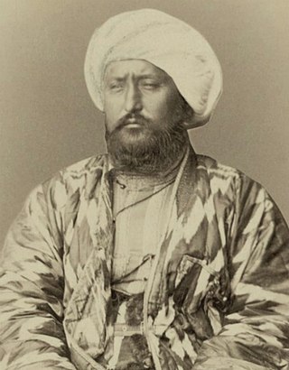
Sayid Muhammad Khudayar Khan, usually abbreviated to Khudayar Khan, was a Khan of Kokand who reigned between 1845 and 1875 with interruptions. He was the son of Shir Ali Khan. During the reign of Khudayar Khan, the Khanate was suffering from a civil war and from interventions of the Emir of Bukhara. Subsequently, the Russian invasion into Central Asia first forced the Khanate to become a vassal of the Russian Empire, and in 1876 the Khanate was abolished as a result of the suppression of an uprising. In 1875, Khudayar Khan, who took a pro-Russian position, during the uprising had to flee to Orenburg in Russia. He died in exile.
This page is based on this Wikipedia article Text is available under the CC BY-SA 4.0 license; additional terms may apply. Images, videos and audio are available under their respective licenses.