Oltiariq

Last updated
Oltiariq
Altyaryk
Urban-type settlement
Uzbekistan adm location map.svg
Red pog.svg
Oltiariq
Location in Uzbekistan
Coordinates: 40°23′30″N71°28′36″E / 40.39167°N 71.47667°E / 40.39167; 71.47667
Country Flag of Uzbekistan.svg Uzbekistan
Region Fergana Region
District Oltiariq District
Urban-type settlement status1980
Elevation
520 m (1,710 ft)
Population
 (2011) [1]
  Total25,543
Time zone UTC+5 (UZT)

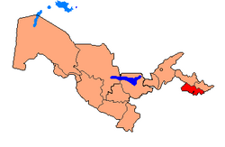
Oltiariq (Uzbek : Oltiariq) is an urban-type settlement in Fergana Region, Uzbekistan. It is the administrative center of Oltiariq District. [2]

Population

The town population in 1989 was 8,781 people. [3]

Related Research Articles

<span class="mw-page-title-main">Uzbekistan</span> Country in Central Asia

Uzbekistan, officially the Republic of Uzbekistan, is a doubly landlocked country located in Central Asia. It is surrounded by five countries: Kazakhstan to the north, Kyrgyzstan to the northeast, Tajikistan to the southeast, Afghanistan to the south, and Turkmenistan to the southwest, making it one of only two doubly landlocked countries on Earth, the other being Liechtenstein. Uzbekistan is part of the Turkic world, as well as a member of the Organization of Turkic States. Uzbek, spoken by the Uzbek people, is the official language and spoken by the majority of its inhabitants, while Russian and Tajik are significant minority languages. Islam is the predominant religion, and most Uzbeks are Sunni Muslims.

<span class="mw-page-title-main">Demographics of Uzbekistan</span>

Demographic features of the population of Uzbekistan include population growth, population density, ethnicity, education level, health, economic status, religious affiliations, and other aspects of the population. The nationality of a person from Uzbekistan is Uzbekistani, while the ethnic Uzbek majority call themselves Uzbeks. Much of the data is estimated because the last census was carried out in Soviet times in 1989.

<span class="mw-page-title-main">Karakalpakstan</span> Autonomous republic of Uzbekistan

Karakalpakstan, officially the Republic of Karakalpakstan, is an autonomous republic of Uzbekistan. It spans the northwestern portion of Uzbekistan. Its capital is Nukus. Karakalpakstan has an area of 166,590 km2 (64,320 sq mi), and has a population of about 2 million people. Its territory covers the classical land of Khwarazm, which in classical Persian literature was known as Kāt (کات).

<span class="mw-page-title-main">Uzbek Soviet Socialist Republic</span> Constituent Republic of the Soviet Union

The Uzbek Soviet Socialist Republic, also known as Soviet Uzbekistan, the Uzbek SSR, UzSSR, or simply Uzbekistan and rarely Uzbekia or Red Uzbekistan, was a union republic of the Soviet Union. It was governed by the Uzbek branch of the Soviet Communist Party, the legal political party, from 1925 until 1990. From 1990 to 1991, it was a sovereign part of the Soviet Union with its own legislation.

<span class="mw-page-title-main">Oltiariq District</span> District in Fergana Region, Uzbekistan

Oltiariq District is a tuman (district) of Fergana Region in Uzbekistan. The capital lies at the town Oltiariq. It has an area of 630 km2 (240 sq mi) and it had 219,100 inhabitants in 2022. The district consists of one city (Tinchlik), 14 urban-type settlements and 15 rural communities.

Ishtixon is a city in Samarqand Region, Uzbekistan. It is the capital of Ishtixon District. In 1989, the population was 10,155 people, and 16,000 in 2016.

Juma, meaning Friday in Uzbek is a city in Samarqand Region, Uzbekistan. It is the capital of Pastdargʻom District. The population of the town was 15,571 people in 1989, and 21,500 in 2016.

Piskent is a city in Tashkent Region, Uzbekistan. It is the capital of Piskent District. The town population was 24,405 people in 1989, and 34,900 in 2016.

Toʻraqoʻrgʻon is a city in Namangan Region, Uzbekistan. It is the administrative center of Toʻraqoʻrgʻon District. The town population was 18,415 people in 1989, and 30,300 in 2016.

Bagʻdod is an urban-type settlement in Fergana Region, Uzbekistan. It is the administrative center of Bagʻdod District. The town population in 1989 was 10,086.

Dangʻara is an urban-type settlement in Fergana Region, Uzbekistan. It is the administrative center of Dangʻara District. Its population was 7,983 people in 1989, and 11,500 in 2016.

Toshloq is an urban-type settlement in Fergana Region, Uzbekistan. It is the administrative center of Toshloq District. The town population in 1989 was 12,067 people, and 18,600 in 2016.

Yaypan is a city in Fergana Region, Uzbekistan. It is the administrative center of Uzbekistan District. The town population was 15,984 people in 1989, and 24,900 in 2016.

The history of the Jews in Central Asia dates back centuries, where Jews have lived in countries which include Kyrgyzstan, Kazakhstan, Tajikistan, Turkmenistan, and Uzbekistan.

Tinchlik is a city in Fergana Region, Uzbekistan. It is part of Oltiariq District. Its population is 14,700 (2016).

Iskandar is an urban-type settlement in Tashkent Region, Uzbekistan. It is part of Boʻstonliq District. In 1989 the town's population was 26,161 people.

Olimkent is an urban-type settlement in Tashkent Region, Uzbekistan. It is part of Oqqoʻrgʻon District. The town population in 1989 was 6435 people.

Oʻrtaovul is an urban-type settlement in Tashkent Region, Uzbekistan. It is part of Zangiota District. The town's population in 1989 was 13,271.

Nasaf are the defending champions.

Shakarxon, daughter of Xoliqboy (1879–1921), was a woman warrior from Oltiariq who participated in the independence movement in Fergana Valley. Shakarxon was an active participant of the national liberation movement in Turkestan. She led a group of 500 people which became famous in the Ferghana Valley as Shakarxon's guard.

References

  1. Uzbekistan, Geoba.se
  2. "Classification system of territorial units of the Republic of Uzbekistan" (in Uzbek and Russian). The State Committee of the Republic of Uzbekistan on statistics. July 2020.
  3. Population census-1989