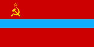
Uzbekistan is the common English name for the Uzbek Soviet Socialist Republic and later, the Republic of Uzbekistan, that refers to the period of Uzbekistan from 1924 to 1991 as one of the constituent republics of the Soviet Union. It was governed by the Uzbek branch of the Soviet Communist Party, the legal political party, from 1925 until 1990. From 1990 to 1991, it was a sovereign part of the Soviet Union with its own legislation. Sometimes, that period is also referred to as Soviet Uzbekistan.

Kokand is a city in Fergana Region in eastern Uzbekistan, at the southwestern edge of the Fergana Valley. Administratively, Kokand is a district-level city, that includes the urban-type settlement Muqimiy. The population of Kokand as of 2022 was approximately 259,700. The city lies 228 km (142 mi) southeast of Tashkent, 115 km (71 mi) west of Andijan, and 88 km (55 mi) west of Fergana. It is nicknamed "City of Winds". In 1877 when the first ethnographic works were done under the new imperial Russian administration, Khoqand/Kokand was reported and visually depicted on their maps as Tajik inhabited oasis (C.E de Ujfalvy. The city and the entire eastern 3/4 of the Fergana Valley were including in Uzbekistan in the 1920s and Stalin's dictates of political borders.
Fergana, or Ferghana, is a district-level city and the capital of Fergana Region in eastern Uzbekistan. Fergana is about 420 km east of Tashkent, about 75 km west of Andijan, and less than 20 km from the Kyrgyzstan border.

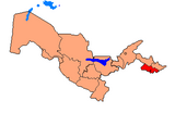
Fergana Region is one of the regions of Uzbekistan, located in the southern part of the Fergana Valley in the far east of the country. It borders the Namangan and Andijan Regions of Uzbekistan, as well as Kyrgyzstan and Tajikistan. Its capital is the city Fergana. It covers an area of 6,760 km2. The population is approximately 3,896,395 as of 2022, with 44% of the population living in rural areas.

The history of the Jews in Uzbekistan refers to the history of two distinct communities; the more religious and traditional Bukharan Jewish community and the, Europe-extracted Ashkenazi community.

Fergana is a district of Fergana Region in Uzbekistan. The capital lies at the town Chimyon. It has an area of 610 km2 (240 sq mi) and it had 220,900 inhabitants in 2022.
Oltiariq is an urban-type settlement in Fergana Region, Uzbekistan. It is the administrative center of Oltiariq District.
Bagʻdod is an urban-type settlement in Fergana Region, Uzbekistan. It is the administrative center of Bagʻdod District. The town population in 1989 was 10,086.
Beshariq is a city in Fergana Region, Uzbekistan. It is the administrative center of Beshariq District. The town population was 17,289 people in 1989, and 22,800 in 2016.
Ibrat is an urban-type settlement in Fergana Region, Uzbekistan. It is the administrative center of Buvayda District. Its population was 7,502 people in 1989, and 8,500 in 2016.
Dangʻara is an urban-type settlement in Fergana Region, Uzbekistan. It is the administrative center of Dangʻara District. Its population was 7,983 people in 1989, and 11,500 in 2016.
Vodil is an urban-type settlement in Fergana Region, Uzbekistan. It is part of Fergana District. Its population was 17,551 people in 1989, and 16,200 in 2016.
Toshloq is an urban-type settlement in Fergana Region, Uzbekistan. It is the administrative center of Toshloq District. The town population in 1989 was 12,067 people, and 18,600 in 2016.
Uchkoʻprik is an urban-type settlement in Fergana Region, Uzbekistan. It is the administrative center of Uchkoʻprik District. Its population was 4,277 people in 1989, and 4,300 in 2016.
Yaypan is a city in Fergana Region, Uzbekistan. It is the administrative center of Uzbekistan District. The town population was 15,984 people in 1989, and 24,900 in 2016.
Yozyovon is an urban-type settlement in Fergana Region, Uzbekistan. It is the capital of Yozyovon District. Its population was 7,458 people in 1989, and 12,800 in 2016.

Quvasoy is a city in Fergana Region in eastern Uzbekistan. Administratively, Quvasoy is a district-level city, that includes the urban-type settlement Doʻstlik and 6 rural communities. The population of Quvasoy is 96,900 (2022). It has an area of 260 km2 (100 sq mi). It lies along the river Isfayramsay, close to the border with Kyrgyzstan.
Shoʻrsuv is an urban-type settlement in Fergana Region, Uzbekistan. It is part of Uzbekistan District. The town population was 2,332 people in 1989, and 2,400 in 2016.
Yangi Margilan is an urban-type settlement in Fergana Region, Uzbekistan. Administratively, it is part of the city Margilan. The town population in 1989 was 23,531 people.
Doʻstlik is an urban-type settlement in Fergana Region, Uzbekistan. Administratively, it is part of the city Quvasoy. The town population in 1989 was 2111 people.