Özgön

Last updated • 1 min readFrom Wikipedia, The Free Encyclopedia
Özgön
Өзгөн
Uzgen
Uzgen Mausoleum.jpg
12th century Karakhanid mausoleum in Özgön
Relief Map of Kyrgyzstan.png
Red pog.svg
Özgön
Location in Kyrgyzstan
West Asia non political with water system.jpg
Red pog.svg
Özgön
Özgön (West and Central Asia)
Asia laea relief location map.jpg
Red pog.svg
Özgön
Özgön (Asia)
Coordinates: 40°46′N73°18′E / 40.767°N 73.300°E / 40.767; 73.300
Country Flag of Kyrgyzstan.svg Kyrgyzstan
Region Osh Region
District Özgön
Elevation
1,029 m (3,375 ft)
Population
 (2021) [1]
  Total62,802
Time zone UTC+6 (KGT)
Map of Central Asia in the 8th century C.E., showing the city of Uzkand (top right, at the Eastern extremity of Farghana) Transoxiana 8th century.svg
Map of Central Asia in the 8th century C.E., showing the city of Uzkand (top right, at the Eastern extremity of Farghana)
French map (1882) of the Fergana valley, showing the city (centre right) under the name of Ousgent Archives des missions scientifiques et litteraires (1882) (19565272478).jpg
French map (1882) of the Fergana valley, showing the city (centre right) under the name of Oûsgent

Özgön (Kyrgyz : Өзгөн) [2] or Uzgen (Russian : Узген) [3] (from Sogdian Uzkand ("city of the Uz ") [4] is a town in Osh Region, Kyrgyzstan. It is a city of district significance and the seat of Özgön District. [2] Its population was 62,802 in 2021. [1]

Contents

History

The town is mentioned in Chinese annals of the second century BC. It was one of the capitals of the Karakhanids, who called it Mavarannahr and left three well-preserved mausolea. Özgön became the abode of Muhammad b. Nasr during the Kara-Khanid split into two branches.

Uzgen Minaret tower. Uzgen Minaret.jpg
Uzgen Minaret tower.

Accounts of Özgön were found in the works of Arab writers like Al-Muqaddasi and Ibn Hawqal in the 10th century. [5]

Population

Historical population
YearPop.±% p.a.
197023,113    
197929,214+2.64%
198934,167+1.58%
199941,497+1.96%
200949,410+1.76%
202162,802+2.02%
Note: resident population; Sources: [6] [1]

Geography

Özgön is located at the far eastern end of the Ferghana Valley, [7] upstream of the point where the Kara-Darya enters the valley. It is 30 miles northeast of Osh, and 20 miles southeast of Jalal-Abad on the banks of the Kara-Darya, on its right side. [8]

Climate

Özgön has a hot summer Mediterranean continental climate (Köppen climate classification Dsa). Summers are hot and dry. Precipitation occurs mostly in winter and its adjacent months.

Climate data for Özgön (1991-2020)
MonthJanFebMarAprMayJunJulAugSepOctNovDecYear
Daily mean °C (°F)−1.2
(29.8)
0.9
(33.6)
7.5
(45.5)
13.7
(56.7)
18.2
(64.8)
22.4
(72.3)
24.7
(76.5)
23.7
(74.7)
19.2
(66.6)
12.4
(54.3)
6.0
(42.8)
0.6
(33.1)
12.3
(54.2)
Average precipitation mm (inches)40.9
(1.61)
51.2
(2.02)
77.8
(3.06)
86.3
(3.40)
71.9
(2.83)
38
(1.5)
19.6
(0.77)
10.9
(0.43)
12.6
(0.50)
54.9
(2.16)
54.6
(2.15)
40.7
(1.60)
559.4
(22.02)
Average precipitation days (≥ 0.1 mm)77.48.68.18.76.44.43.12.94.95.76.173.3
Average relative humidity (%)77.374.966.656.851.844.646.15052.860.26977.960.7
Source 1: NOAA [9]
Source 2: "The Climate of Uzgen". Weatherbase. Retrieved 31 July 2014.

Famous people

Mirza Abu Bakr Dughlat's unsuccessful attempt to capture Ozgon (from the Baburnama). 1494-Abubekr Duglat attempting unsuccessfully to take Uzgend th.jpg
Mirza Abu Bakr Dughlat's unsuccessful attempt to capture Özgön (from the Baburnama).

One of the middle/high schools of Özgön was named after him.

Related Research Articles

<span class="mw-page-title-main">Osh</span> City in southern Kyrgyzstan

Osh is the second-largest city in Kyrgyzstan, located in the Fergana Valley in the south of the country. It is often referred to as the "capital of the south". It is the oldest city in the country and has served as the administrative center of Osh Region since 1939. The city has an ethnically mixed population of 322,164 in 2021, comprising Kyrgyz, Uzbeks, Ukrainians, Koreans, and other smaller ethnic groups.

<span class="mw-page-title-main">Osh Region</span> Region of Kyrgyzstan

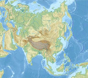
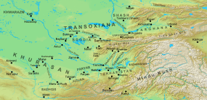
Osh Region is a region of Kyrgyzstan. Its capital is Osh, which is not part of the region. It is bounded (clockwise) by Jalal-Abad Region, Naryn Region, China (Xinjiang), Tajikistan, Batken Region, and Uzbekistan. Its total area is 28,934 km2 (11,171 sq mi). The resident population of the region was 1,391,649 as of January 2021. The region has a sizeable Uzbek minority.

Kara-Suu is a town in Osh Region, Kyrgyzstan, in the Fergana Valley. The town is 23 km northeast of Osh and is the capital of Kara-Suu District. Its population was 26,609 in 2021. It is a major industrial and trade center, on the border with Uzbekistan. On the other side of the border is the town Qorasuv.

<span class="mw-page-title-main">Razzakov</span> Town in Batken, Kyrgyzstan

Razzakov, formerly known as Isfana, is a small town in the extreme western end of Batken Region in southern Kyrgyzstan. The town is located in the southern part of the Fergana Valley, in a region surrounded on three sides by Tajikistan. It was renamed by President Sadyr Japarov in honour of Iskhak Razzakov on March 18, 2022.

Kara-Balta is a city and municipality on the Kara-Balta River, in Chüy Region, in northern Kyrgyzstan, the capital of Jayyl District. Its population was 48,278 in 2021.

Gülchö is a mountain town in Osh Region of Kyrgyzstan. It is the seat of Alay District. Its population was 13,755 in 2021.

Ak-Terek is a village in Osh Region of Kyrgyzstan about 43 km northeast of Özgön and 4 km northeast of Salam-Alik on the Jazy river. It is part of the Özgön District. Its population was 1,349 in 2021. It is a base for horse trekking in the Fergana Range.

Kyzyl-Senggir is a village in Osh Region of Kyrgyzstan. It is part of the Özgön District. Its population was 5,077 in 2021.

Kara-Kulja is the center of Kara-Kulja District in Osh Region of Kyrgyzstan.

Myrza-Ake is a large village in the Osh Region of Kyrgyzstan. It is part of the Özgön District. Its population was 16,011 in 2021.

Kara-Dyykan ) is a village in Osh Region of Kyrgyzstan. It is part of the Özgön District. Its population was 7,492 in 2021.

Jangy-Jol is a village in Osh Region of Kyrgyzstan. It is part of the Özgön District. Its population was 257 in 2021.

Sasyk-Bulak is a village in the Osh Region of Kyrgyzstan. It is part of the Özgön District. Its population was 565 in 2021.

<span class="mw-page-title-main">Alay District</span> District in Osh Region, Kyrgyzstan

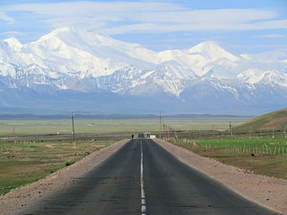
Alay is a district of Osh Region in south-western Kyrgyzstan. The capital lies at Gülchö. The Alay District borders with China in the east, Tajikistan in the south, Chong-Alay District in the west, Nookat District in the north-west, Kara-Suu District and Özgön District in the north, and Kara-Kulja District in the north-east. Its area is 6,821 square kilometres (2,634 sq mi), and its resident population was 87,398 in 2021.

<span class="mw-page-title-main">Chong-Alay District</span> District in Osh Region, Kyrgyzstan

Chong-Alay District is a district of Osh Region in far south-western Kyrgyzstan. The administrative seat lies at Daroot-Korgon. Its area is 4,857 square kilometres (1,875 sq mi), and its resident population was 32,140 in 2021. The Chong-Alay District include 3 rural communities : Chong-Alay, Kashka-Suu, and Jekendi.

<span class="mw-page-title-main">Özgön District</span> District in Osh Region, Kyrgyzstan

Özgön or Uzgen is a district of Osh Region in south-western Kyrgyzstan. Its area is 3,308 square kilometres (1,277 sq mi), and its resident population was 282,981 in 2021. The capital lies at Özgön (Uzgen).

<span class="mw-page-title-main">Kurshab</span> Place in Osh, Kyrgyzstan

Kurshab is a large village in Osh Region of Kyrgyzstan. It is part of the Özgön District. Its population was 20,471 in 2021. It is situated near the river Kurshab, between the cities Osh and Özgön.

Myrza-Aryk is a village in Osh Region of Kyrgyzstan. It is part of the Özgön District. Its population was 7,013 in 2021.

Sheraly is a village in Osh Region of Kyrgyzstan. It is part of the Özgön District. Its population was 5,200 in 2021.

Shoro-Bashat is a village in Osh Region of Kyrgyzstan. It is part of the Özgön District. Its population was 5,808 in 2021.

References

  1. 1 2 3 "Population of regions, districts, towns, urban-type settlements, rural communities and villages of Kyrgyz Republic" (XLS) (in Russian). National Statistics Committee of the Kyrgyz Republic. 2021. Archived from the original on 10 November 2021.
  2. 1 2 "Classification system of territorial units of the Kyrgyz Republic" (in Kyrgyz). National Statistics Committee of the Kyrgyz Republic. May 2021. p. 59.
  3. Узген in the Great Soviet Encyclopedia , 1969–1978 (in Russian)
  4. Room, Adrian (2006). Placenames of the World: Origins and Meanings of the Names for 6,600 Countries, Cities, Territories, Natural Features and Historic Sites (2nd ed.). London: McFarland. p. 330. ISBN 978-0-7864-2248-7.
  5. David Nicolle (2008). Saracen Strongholds AD 630-1050: The Middle East and Central Asia. Osprey Publishing. pp. 46–. ISBN   978-1-84603-115-1.[ permanent dead link ]
  6. "2009 population and housing census of the Kyrgyz Republic: Osh Region" (PDF) (in Russian). National Statistics Committee of the Kyrgyz Republic. 2010. p. 201.
  7. Jonathan Bloom; Sheila Blair (14 May 2009). Grove Encyclopedia of Islamic Art & Architecture: Three-Volume Set. OUP USA. pp. 2–. ISBN   978-0-19-530991-1.
  8. Timur Beisembiev (19 December 2013). The Life of Alimqul: A Native Chronicle of Nineteenth Century Central Asia. Routledge. pp. 58–. ISBN   978-1-136-81997-1.
  9. "Climate Normals 1991–2020". National Oceanic and Atmospheric Administration . Retrieved 1 November 2023.