Osh Region

Last updated
Osh Region
  • Ош облусу (Kyrgyz)
  • Ошская область (Russian)
Region
Osh 03-2016 img31 view from Sulayman Mountain pano.jpg
Sulaiman-Too Mosque Osh Kyrgyzstan (3).jpg
Stans08-341 (3134246791).jpg
From the top, View of Osh on Sulayman Mountain, Sulayman-Too Mosque in Osh, National Historical and Archaeological Museum Complex
Flag of Osh.svg
Coat of arms of Osh.svg
Osh Province in Kyrgyzstan.svg
Map of Kyrgyzstan, location of Osh Region highlighted
Coordinates: 40°0′N73°0′E / 40.000°N 73.000°E / 40.000; 73.000
Country Flag of Kyrgyzstan.svg  Kyrgyzstan
Capital Osh
Government
   Governor Taalaibek Sarybashev
Area
  Total
28,934 km2 (11,171 sq mi)
Population
 (2023-01-01) [1]
  Total
1,460,425
  Density50/km2 (130/sq mi)
Time zone UTC+6 (KGT)
ISO 3166 code KG-O
Districts 7
Cities 3
Villages 474

Osh Region [a] is a region of Kyrgyzstan. Its capital is Osh, which is not part of the region. [2] It is bounded (clockwise) by Jalal-Abad Region, Naryn Region, China (Xinjiang), Tajikistan (Districts under Central Government Jurisdiction and Gorno-Badakhshan Autonomous Region), Batken Region, and Uzbekistan (Andijan and Fergana Regions). Its total area is 28,934 km2 (11,171 sq mi). [3] The resident population of the region was 1,391,649 as of January 2021. [1] The region has a sizeable Uzbek (28.0% in 2009) minority. [3]

Contents

Geography

Most of the population lives in the flat northern part of the region, on the edge of the Ferghana Valley. The land gradually rises southward to the crest of the Alay Mountains, drops into the Alay Valley and rises to the Trans-Alai Range which forms the border with Tajikistan. In the east, the land rises to the Ferghana Range, roughly parallel to the Naryn border. This area is drained by the Kara Darya which flows northwest to join the Naryn to form the Syr Darya in the Ferghana Valley.

Highway M41 goes south over the mountains from Osh to the Tajik border. At Sary-Tash a branch goes east to the Chinese border crossing at Irkeshtam. The other main road goes west through the flat country to Batken Region.
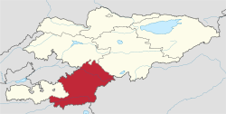
Divisions

The Osh Region is divided administratively into seven districts: [2]

DistrictSeatMap
Alay District Gülchö Kyrgyzstan Alay Raion.png
Aravan District Aravan Kyrgyzstan Aravan Raion.png
Chong-Alay District Daroot-Korgon Kyrgyzstan Chong-Alay Raion.png
Kara-Kulja District Kara-Kulja Kyrgyzstan Kara-Kulja Raion.png
Kara-Suu District Kara-Suu Kyrgyzstan Kara-Suu Raion.png
Nookat District Nookat Kyrgyzstan Nookat Raion.png
Özgön District Özgön Kyrgyzstan Ozgon Raion.png

Kara-Suu, Nookat and Özgön are cities of district significance. There are no urban-type settlements in the region. [2]

Demographics

The resident population of Osh Region, according to the Population and Housing Census of 2009, was 1,104,248. Of these, 87,824 people live in urban areas, and 1,016,424 in rural ones. [3] The official population estimate for the beginning of 2021 was 1,391,649. [1]

Historical populations in Osh Region
YearPop.±%
1970433,029    
1979554,480+28.0%
1989712,643+28.5%
1999943,566+32.4%
20091,104,248+17.0%
20211,391,649+26.0%
Note: resident population; Sources: [3] [1]

Ethnic composition

The largest ethnic minority group in Osh Region is Uzbeks, forming 28% of the regional population (308,688 people) according to the 2009 census. [3] In 2009, 40% of all Kyrgyzstan's Uzbeks lived in Osh Region. [4] According to the 2009 Census, the ethnic composition of the Osh Region (resident population) was: [3]

Ethnic groupPopulationProportion of population
Kyrgyzs 758,03668.6%
Uzbeks 308,68828.0%
Uygurs 11,1811.0%
Turks 10,9341.0%
Tajiks 6,7110.6%
Azerbaijanis 3,2240.3%
Russians 1,5520.1%
Tatars 1,3370.1%
Dungans 7930.1%
other groups1,7920.2%

Enclaves and exclaves

Kyrgyzstan's only exclave within Uzbekistan is administratively part of Osh Region (Kara-Suu District). This is the tiny village of Barak (population 627) in the Fergana valley, located on the road from Osh (Kyrgyzstan) to Xoʻjaobod (Uzbekistan) about 4 km north-west from the Kyrgyz–Uzbek border in the direction of Andijan. [5]

References

Notes

    • Kyrgyz: Ош облусу, romanized: Osh oblusu, IPA: [ɔ́ɕɔ́b̥ɫʊsʊ́]
    • ‹The template Lang-rus is being considered for deletion.› Russian:Ошская область, romanized:Ošskaja oblastj, IPA: [ˈoʂskəjəˈobɫəsʲtʲ]
    • Uzbek: Ўш вилояти, romanized: Oʻsh viloyati, IPA: [ˈɵʃʋɪlɒjæˈtʰɪ]

Citations

  1. 1 2 3 4 "Population of regions, districts, towns, urban-type settlements, rural communities and villages of Kyrgyz Republic" (XLS) (in Russian). National Statistics Committee of the Kyrgyz Republic. 2021. Archived from the original on 10 November 2021.
  2. 1 2 3 "Classification system of territorial units of the Kyrgyz Republic" (in Kyrgyz). National Statistics Committee of the Kyrgyz Republic. May 2021. pp. 46–63.
  3. 1 2 3 4 5 6 "2009 population and housing census of the Kyrgyz Republic: Osh Region" (PDF) (in Russian). National Statistics Committee of the Kyrgyz Republic. 2010. pp. 12, 17, 51, 186.
  4. Population and Housing Census 2009. Chapter 3.1. Resident population by nationality (PDF) (in Russian), Bishkek: National Committee on Statistics, 2010, retrieved 2021-12-15
  5. Map showing the location of the Kyrgyz exclave Barak. Retrieved on 2 May 2009.

Sources