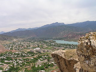
Jalal-Abad Region is a region (oblast) of Kyrgyzstan. Its capital is the city of the same name, Jalal-Abad. It is surrounded by Talas Region, Chüy Region, Naryn Region, Osh Region, and Uzbekistan. Jalal-Abad Region was established on 21 November 1939. On 27 January 1959 it became a part of Osh Region, but regained its old status as a region on 14 December 1990. Its total area is 32,418 km2 (12,517 sq mi). The resident population of the region was 1,260,617 as of January 2021. The region has a sizeable Uzbek minority.

Osh Region is a region (oblast) of Kyrgyzstan. Its capital is Osh, which is not part of the region. It is bounded by (clockwise) Jalal-Abad Region, Naryn Region, China (Xinjiang), Tajikistan, Batken Region, and Uzbekistan. Its total area is 28,934 km2 (11,171 sq mi). The resident population of the region was 1,391,649 as of January 2021. The region has a sizeable Uzbek minority.

Erkeshtam, also Irkeshtam or Erkech-Tam, is a border crossing between Kyrgyzstan and Xinjiang, China, named after a village on the Kyrgyz side of the border in southern Osh Region. The border crossing is also called Simuhana (斯姆哈纳), after the first settlement on the Chinese side of the border, but Erkeshtam is now the more common name used in both countries.
Sary-Mogol is a village in Osh Region of Kyrgyzstan. It is part of the Alay District. Its population was 5,215 in 2021. It lies in the Alay Valley, north of the river Kyzyl-Suu, 32 km west of Sary-Tash.

Sary-Tash is a village and major crossroads in the Alay Valley of Osh Region, Kyrgyzstan. Its population was 2,337 in 2021. Until 2012 it was an urban-type settlement. Nearby towns and villages to the north include Ak-Bosogo and Chagyr.

Kadamjay District is a district in Batken Region, in south-western Kyrgyzstan. The administrative seat lies at Kadamjay. The district area is 6,146 square kilometres (2,373 sq mi), and its resident population was 201,457 in 2021. The largest town of the district, Kadamjay, is located between the cities of Aydarken (Khaidarkan) and Kyzyl-Kyya.

Jayyl is a district of Chüy Region in northern Kyrgyzstan. Its area is 3,453 square kilometres (1,333 sq mi), and its resident population was 112,211 in 2021. The administrative seat lies at Kara-Balta. It also administers an exclave in the southwestern heel of Chüy Region, separated from the rest of the Jayyl District by the Panfilov District.

Tüp is a district of Issyk-Kul Region in north-eastern Kyrgyzstan. The seat lies at Tüp. Its area is 2,121 square kilometres (819 sq mi), and its resident population was 65,169 in 2021. It borders Issyk-Kul District to the west, Ak-Suu District to the east and south-east, Kazakhstan to the north, and Issyk Kul to the south.

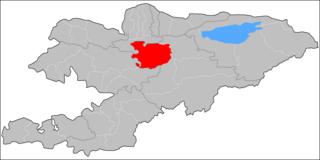
Toktogul is a district of Jalal-Abad Region in western Kyrgyzstan. The administrative seat lies at Toktogul. Its area is 7,815 square kilometres (3,017 sq mi), and its resident population was 103,310 in 2021.
Jumgal is a district of Naryn Region in central Kyrgyzstan. The administrative seat lies at Chaek. Its area is 4,803 square kilometres (1,854 sq mi), and its resident population was 44,866 in 2021. It is a mountainous district. Its main rivers are the Kökömeren and its tributaries Jumgal, Suusamyr and Batysh Karakol.
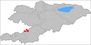
Alay is a district of Osh Region in south-western Kyrgyzstan. The capital lies at Gülchö. The Alay District borders with China in the east, Tajikistan in the south, Chong-Alay District in the west, Nookat District in the north-west, Kara-Suu District and Özgön District in the north, and Kara-Kulja District in the north-east. Its area is 6,821 square kilometres (2,634 sq mi), and its resident population was 87,398 in 2021.
Aravan is a district of Osh Region in south-western Kyrgyzstan. The administrative seat lies at Aravan. Its area is 1,340 square kilometres (520 sq mi), and its resident population was 137,721 in 2021.

Chong-Alay District is a district of Osh Region in far south-western Kyrgyzstan. The administrative seat lies at Daroot-Korgon. Its area is 4,857 square kilometres (1,875 sq mi), and its resident population was 32,140 in 2021. The Chong-Alay District include 3 rural communities : Chong-Alay, Kashka-Suu, and Jekendi.

Kara-Kulja is a district of Osh Region in south-western Kyrgyzstan. Its area is 5,813 square kilometres (2,244 sq mi), and its resident population was 100,320 in 2021. The administrative seat lies at Kara-Kulja.

Kara-Suu is a district of Osh Region in south-western Kyrgyzstan. Its area is 3,616 square kilometres (1,396 sq mi), and its resident population was 448,608 in 2021. The administrative seat lies at the city Kara-Suu.

Özgön or Uzgen is a district of Osh Region in south-western Kyrgyzstan. Its area is 3,308 square kilometres (1,277 sq mi), and its resident population was 282,981 in 2021.> The capital lies at Özgön (Uzgen).
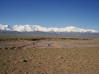
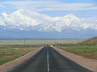
The Alay Valley is a broad, dry valley running east–west across most of southern Osh Region, Kyrgyzstan. It spreads over a length of 174 km (108 mi) east–west. The valley extends in north–south direction with varying width of 27 km (17 mi) in the west, 40 km (25 mi) in the central part, and 3–7 km (1.9–4.3 mi) in the east. The altitude of the valley ranges from 2,440 m (8,010 ft) near Karamyk to 3,536 m (11,601 ft) at Toomurun Pass with an average altitude of about 3,000 m (9,800 ft). The area of the valley is 8,400 km2 (3,200 sq mi). The north side is the Alay Mountains which slope down to the Ferghana Valley. The south side is the Trans-Alay Range along the Tajikistan border, with Lenin Peak,. The western 40 km (25 mi) or so is more hills than valley. On the east there is the low Tongmurun pass and then more valley leading to the Irkestam border crossing to China.
The Muksu is a west-flowing river in northeastern Tajikistan. It is a tributary of the Vakhsh which in turn is a tributary of the Amu Darya. The river is 88 kilometres (55 mi) long and has a basin area of 7,070 square kilometres (2,730 sq mi). It is formed at the confluence of the rivers Seldara and Sauksay, near Altyn Mazar. The north side of its valley is the Trans-Alay Range and the south side is formed by the Peter I Range and the Academy of Sciences Range. It joins the Kyzyl-Suu to form the Surkhob or Vakhsh. At Altyn Mazar there is a pass leading north to Daroot-Korgon in the Alay Valley.
Karamyk is a village in the Osh Region of Kyrgyzstan. It is part of the Chong-Alay District. It is on the river Vakhsh (Kyzyl-Suu), in the Alay Valley near the border with Tajikistan. The village is a Kyrgyz-Tajik border crossing on European route E60 (AH65). Its population was 3,324 in 2021.

