Districts of Kyrgyzstan

Last updated

The regions of Kyrgyzstan are divided into districts (raions), administered by government-appointed officials. Rural communities (ayyl aymagy) consisting of up to twenty small settlements have their own elected mayors and councils. The raions are listed below, by region:

Contents

Rural raions of Kyrgyzstan Kyrgyzstan districts numbered.png
Rural raions of Kyrgyzstan

North Kyrgyzstan

Bishkek City

The capital city of Bishkek has the status of region [1] and is divided into four districts: [2]

DistrictKyrgyz namePopulation (2009)
Birinchi May Биринчи май171,467
Lenin Ленин198,019
Oktyabr Октябрь238,329
Sverdlov Свердлов214,100

Chüy Region

Chüy Region is divided administratively into 8 districts: [2] [3]

DistrictKyrgyz nameCapitalPopulation (2009)Area (km2)Density (/km2)Rural
communities
TownsUrban-type
settlements
VillagesNumber
on map
Alamüdün Аламүдүн Lebedinovka 147,2081,5039817**5027
Chüy Чүй Tokmok 44,7531,75625.510**3829
Jayyl Жайыл Kara-Balta 90,3483,43526.3121*3624
Kemin Кемин Kemin 41,9243,53311.911213430
Moskva Москва Belovodskoye 83,6412,05640.712**2825
Panfilov Панфилов Kayyngdy 39,8372,60615.361*2023
Sokuluk Сокулук Sokuluk 158,1372,55062191*6826
Ysyk-Ata Ысык-Ата Kant 131,5032,41554.5181*5628

Issyk-Kul Region

Issyk-Kul Region is divided administratively into 5 districts: [2]

DistrictKyrgyz nameCapitalPopulation (2009)Area (km2)Density (/km2)Rural
communities
TownsUrban-type
settlements
VillagesNumber
on map
Ak-Suu Ак-Суу Teploklyuchenka 62,5249,9176.314**3940
Issyk-Kul Ысык-Көл Cholpon-Ata 74,9733,60320.8121*3036
Jeti-Ögüz Жети-Өгүз Kyzyl-Suu 79,32814,4995.513**4739
Tong Тоң Bökönbaev 48,8707,2306.89**3038
Tüp Түп Tüp 56,4162,12126.613**3737

Naryn Region

Naryn Region is divided administratively into 5 districts: [2]

DistrictKyrgyz nameCapitalPopulation (2009)Area (km2)Density (/km2)Rural
communities
TownsUrban-type
settlements
VillagesNumber
on map
Ak-Talaa Ак-талаа Baetov 30,6437,2664.213**1933
At-Bashy Ат-Башы At-Bashy 49,23815,3543.211**1835
Jumgal Жумгал Chaek 40,7184,8038.513**2831
Kochkor Кочкор Kochkor 58,2675,8689.911**3232
Naryn Нарын Naryn 44,08010,5024.2151*3934

Talas Region

Talas Region is divided administratively into 4 districts: [2]

DistrictKyrgyz nameCapitalPopulation (2009)Area (km2)Density (/km2)Rural
communities
TownsUrban-type
settlements
VillagesNumber
on map
Bakay-Ata Бакай-Ата Bakay-Ata 44,0572,928159**1920
Kara-Buura Кара-Буура Kyzyl-Adyr 58,0564,2161410**2319
Manas Манас Pokrovka 32,9131,198275**2221
Talas Талас Manas 58,8675,0511213**2722

South Kyrgyzstan

Batken Region

Batken Region is divided administratively into 3 districts: [2]

DistrictKyrgyz nameCapitalPopulation (2009)Area (km2)Density (/km2)Rural
communities
TownsUrban-type
settlements
VillagesNumber
on map
Batken Баткен Batken 69,5915,94811.7***422
Kadamjay Кадамжай Kadamjay 157,5976,14625.6**41033
Leylek Лейлек Isfana 116,8614,65325.1*1*461

Jalal-Abad Region

Jalal-Abad Region is divided administratively into 8 districts: [2]

DistrictKyrgyz nameCapitalPopulation (2009)Area (km2)Density (/km2)Rural
communities
TownsUrban-type
settlements
VillagesNumber
on map
Aksy Аксы Kerben 106,0494,57823.2*1*6814
Ala-Buka Ала-Бука Ala-Buka 81,4882,97627.4***4115
Bazar-Korgon Базар-Коргон Bazar-Korgon 132,0511,96567.2***5712
Chatkal Чаткал Kanysh-Kyya 21,1544,6084.6**2916
Nooken Ноокен Masy 109,6872,33647*1*5413
Suzak Сузак Suzak 220,6753,01973.1*1*12311
Toguz-Toro Тогуз-Торо Kazarman 21,4173,8165.6***1318
Toktogul Токтогул Toktogul 83,4797,81510.7**14417

Osh Region

Osh Region is divided administratively into 7 districts: [2]

DistrictKyrgyz nameCapitalPopulation (2009)Area (km2)Density (/km2)Rural
communities
TownsUrban-type
settlements
VillagesNumber
on map
Alay Алай Gülchö 72,1706,8211114**628
Aravan Араван Aravan 106,1341,340798**486
Chong-Alay Чоң Алай Daroot-Korgon 25,0394,8575.23**224
Kara-Kulja Кара-Кулжа Kara-Kulja 87,6915,8131512**4910
Kara-Suu Кара-Суу Kara-Suu 348,6453,61696161*1227
Nookat Ноокат Nookat 236,4553,17974161*755
Özgön Өзгөн Özgön 228,1143,30869191*999

See also

Related Research Articles

Bishkek Capital of Kyrgyzstan

Bishkek, formerly Pishpek and Frunze, is the capital and largest city of Kyrgyzstan. Bishkek is also the administrative centre of the Chuy Region. The region surrounds the city, although the city itself is not part of the region but rather a region-level unit of Kyrgyzstan. It is also near the Kazakhstan–Kyrgyzstan border. Its population was 1,074,075 in 2021.

Kyrgyzstan Country in Central Asia

Kyrgyzstan, sometimes called Kirghizia, officially the Kyrgyz Republic, is a mountainous landlocked country in Central Asia. Kyrgyzstan is bordered by Kazakhstan to the north, Uzbekistan to the west, Tajikistan to the south, and China to the east. Its capital and largest city is Bishkek. Ethnic Kyrgyz make up the majority of the country's six million people, followed by significant minorities of Uzbeks and Russians. The Kyrgyz language is closely related to other Turkic languages, although Russian remains spoken and is a co-official language. Ninety percent of Kyrgyzstan's population are Muslim, with the majority of its population following Sunni Islam. In addition to its Turkic origins, Kyrgyz culture bears elements of Iranic, Mongolian and Russian influence.

Regions of Kyrgyzstan Regions of Kyrgyzstan

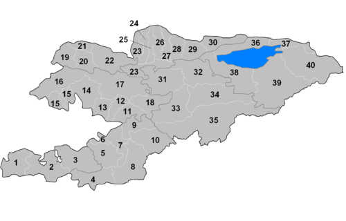
Kyrgyzstan is divided into seven regions. The capital, Bishkek, is administratively an independent city of republican significance, as well as being the capital of Chuy Region. Osh also has independent city status since 2003.

Chu (river) River in Kyrgyzstan and Kazakhstan

The Chu is a river in Northern Kyrgyzstan and Southern Kazakhstan. Of its total length of 1,067 kilometres (663 mi), the first 115 kilometres are in Kyrgyzstan, then for 221 kilometres the river is the border between Kyrgyzstan and Kazakhstan and the last 731 kilometres are in Kazakhstan. It is one of the longest rivers in Kyrgyzstan and in Kazakhstan. It has a drainage basin of 62,500 square kilometres (24,100 sq mi).

Chuy Region Region of Kyrgyzstan

Chuy Region is the northernmost region (oblast) of the Kyrgyz Republic. This region surrounds the national capital of Kyrgyzstan, Bishkek. It is bounded on the north by Kazakhstan, and clockwise, Issyk-Kul Region, Naryn Region, Jalal-Abad Region, and Talas Region. Its administrative center is Bishkek. Its total area is 19,895 km2 (7,682 sq mi). The resident population of the region was 974,984 as of January 2021. The region has sizeable Russian and Dungan minorities.

Jalal-Abad Region Region of Kyrgyzstan

Jalal-Abad Region, also known as Jalalabat, is a region (oblast) of Kyrgyzstan. Its capital is the city of the same name, Jalal-Abad. It is surrounded by Talas Region, Chuy Region, Naryn Region, Osh Region, and Uzbekistan. Jalal-Abad Region was established on 21 November 1939. On 27 January 1959 it became a part of Osh Region, but regained its old status as a region on 14 December 1990. Its total area is 32,418 km2 (12,517 sq mi). The resident population of the region was 1,260,617 as of January 2021. The region has a sizeable Uzbek minority.

Naryn Region Region of Kyrgyzstan

Naryn Region is the largest region (oblus) of Kyrgyzstan. It is located in the east of the country and borders with Chuy Region in the north, Issyk-Kul Region in the northeast, Xinjiang Uyghur Autonomous Region of China in the southeast, Osh Region in the southwest, and Jalal-Abad Region in the west. Its capital is Naryn. Its total area is 44,160 km2 (17,050 sq mi). The resident population of the region was 292,140 as of January 2021.

Talas Region Region of Kyrgyzstan

Talas Region is a region (oblast) of Kyrgyzstan. Its capital is Talas. It is bordered on the west and north by Jambyl Region of Kazakhstan, on the east by Chuy Region, on the south by Jalal-Abad Region and on the southwest by a finger of Uzbekistan. Its total area is 13,406 km2 (5,176 sq mi). The resident population of the region was 270,994 as of January 2021. The historic Battle of Talas occurred here.

Issyk-Kul Region Region of Kyrgyzstan

Issyk-Kul Region is one of the regions of Kyrgyzstan. Its capital is Karakol. It is surrounded by Almaty Region, Kazakhstan (north), Chuy Region (west), Naryn Region (southwest) and Xinjiang, China (southeast). It takes its name from Lake Issyk-Kul, the world's second-largest high altitude lake. Its total area is 43,735 km2 (16,886 sq mi). The resident population of the region was 501,933 as of January 2021. The region has a sizeable Russian minority.
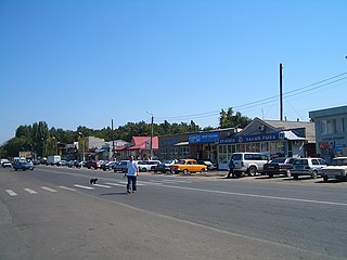
Tokmok Place in Chuy Region, Kyrgyzstan

Tokmok is a city in the Chuy Valley, northern Kyrgyzstan, east of the country's capital of Bishkek, with a population of 71,443 in 2021. Its elevation is 816 m above sea level. From 2003 to 2006, it was the administrative seat of Chuy Region. Just to the north is the river Chu and the border with Kazakhstan.

Kant, Kyrgyzstan Place in Chuy Region, Kyrgyzstan

Kant is a town in the Chuy Valley of northern Kyrgyzstan, some 20 kilometres (12 mi) east of Bishkek. It is the administrative center of the Ysyk-Ata District. Its population was 22,617 in 2021. Kant was established in 1928.

Kemin Place in Chuy Region, Kyrgyzstan

Kemin is a city in northeastern Kyrgyzstan, the administrative headquarters of Kemin District in Chuy Region. Its population was 10,354 in 2021. It is located about 95 km eastward of Bishkek on the left bank of the river Chuy in the Chuy Valley. Kemin was established in 1912. Kemin received city right in 2012.

Kara-Balta Place in Chuy Region, Kyrgyzstan

Kara-Balta is a city and municipality on the Kara-Balta River, in Chuy Region, Kyrgyzstan, the capital of Jayyl District. It was founded in 1825 under the Kokand Khanate, and received city status in 1975 under the Soviets. Its population was 48,278 in 2021.

Mayevka, Kyrgyzstan Place in Chuy Region, Kyrgyzstan

Mayevka is a village in the Alamüdün District in Chuy Region of Kyrgyzstan. Its population was 10,535 in 2021. It was established in 1930.

Alamüdün Place in Chuy Region, Kyrgyzstan

Alamüdün is a town and northern suburb of Bishkek in Chuy Region of Kyrgyzstan, part of Alamüdün District (raion). Its population was 12,198 in 2021. It lies along the M39 highway which leads to Korday on the Kazakh border and further to Almaty. Alamüdün contains an elm grove park to the west with Lake Komsomolskoye. Its main market is the Alamüdün Bazaar and its football club, FC Alamudun, plays in the top division in Kyrgyzstan, the Kyrgyzstan League. It is the birthplace of Tatyana Kolpakova.

Sokuluk Place in Chuy Region, Kyrgyzstan

Sokuluk is a large village in the Chuy Region of Kyrgyzstan. Divided over two rural communities, its total population was 30,540 in 2021.

Orlovka, Kyrgyzstan Place in Chuy Region, Kyrgyzstan

Orlovka is a city in Kemin District of Chuy Region. Its population was 6,167 in 2021. It is the center of Orlovka municipal council that also includes Podgornoye village. Orlovka was established in 1910. It became a city in 2012.

Sosnovka, Kyrgyzstan Place in Chuy, Kyrgyzstan

Sosnovka is a village in the Jayyl District of Chuy Region of Kyrgyzstan. Its population was 5,972 in 2021. It is the center and the only village in Sosnovka rural community. Bishkek - Osh road passes through Sosnovka.

Talas, Kyrgyzstan Place in Talas Region, Kyrgyzstan

Talas is a town in northwestern Kyrgyzstan, located in the Talas river valley between two mountain ranges. Its area is 13 square kilometres (5.0 sq mi), and its resident population was 40,308 in 2021. It is the administrative headquarters of Talas Region. The town was founded by East Slavic settlers in 1877. To the south is the Besh-Tash valley with the Besh-Tash National Park.

Novopokrovka, Chuy Place in Chuy Region, Kyrgyzstan

Novopokrovka is a village in the Ysyk-Ata District of Chuy Region of Kyrgyzstan. Divided over two rural communities, its total population was 21,619 in 2021.

References

  1. Law on the Status of Bishkek Archived July 21, 2011, at the Wayback Machine , 16 April 1994, article 2 (in Russian). Retrieved on 7 April 2009
  2. 1 2 3 4 5 6 7 8 "Classification system of territorial units of the Kyrgyz Republic" (in Kyrgyz). National Statistics Committee of the Kyrgyz Republic. May 2021. pp. 98–100.
  3. The Government of the Chuy Region: The districts of Chuy Oblast Archived August 24, 2007, at the Wayback Machine (in Russian)