
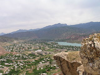
Jalal-Abad is the administrative and economic centre of Jalal-Abad Region in southwestern Kyrgyzstan. Its area is 88 square kilometres (34 sq mi), and its resident population was 123,239 in 2021. It is situated at the north-eastern end of the Fergana valley along the Kögart river valley, in the foothills of the Babash Ata mountains, very close to the Uzbekistan border.
Jalal-Abad Region, also known as Jalalabat, is a region (oblast) of Kyrgyzstan. Its capital is the city of the same name, Jalal-Abad. It is surrounded by Talas Region, Chuy Region, Naryn Region, Osh Region, and Uzbekistan. Jalal-Abad Region was established on 21 November 1939. On 27 January 1959 it became a part of Osh Region, but regained its old status as a region on 14 December 1990. Its total area is 32,418 km2 (12,517 sq mi). The resident population of the region was 1,260,617 as of January 2021. The region has a sizeable Uzbek minority.

Talas Region is a region (oblast) of Kyrgyzstan. Its capital is Talas. It is bordered on the west and north by Jambyl Region of Kazakhstan, on the east by Chuy Region, on the south by Jalal-Abad Region and on the southwest by a finger of Uzbekistan. Its total area is 13,406 km2 (5,176 sq mi). The resident population of the region was 270,994 as of January 2021. The historic Battle of Talas occurred here.

Kök-Janggak is a city in Jalal-Abad Region in western Kyrgyzstan, located at a distance of about 29 km from the regional centre city Jalal-Abad. Its population was 12,117 in 2021. It is a city of regional significance within the Suzak District.
Besh-Badam is a village in Jalal-Abad Region of Kyrgyzstan. Its population was 1,720 in 2021. Formerly a village within the rural community of Bazar-Korgon, it was merged into the new city of Bazar-Korgon in January 2021.
Örüktü is a village in Jalal-Abad Region of Kyrgyzstan. It is part of the Ala-Buka District. Its population was 3,831 in 2021.
Kara-Köl is a city in Jalal-Abad Region of Kyrgyzstan. It is a city of regional significance, not part of a district. Its area is 1,050 square kilometres (410 sq mi), and its resident population was 26,901 in 2021. Kara-Köl consists of the town proper, the urban-type settlement Ketmen-Töbö and the village Jazy-Kechüü.
Terek-Say is a village in Jalal-Abad Region of Kyrgyzstan, established in 1950 along with the commissioning of the Terek-Say antimony mine. Its population was 3,708 in 2021. It is located at an altitude of 1700 meters above sea level on the main highway about 30 km west northwest of Ala-Buka. In Soviet times, the activity of the settlement was dependent on the mine and the Chatkal Geological Expedition. With the dissolution of the Soviet Union in 1991, mine production sharply declined due to severance of economic ties, the abandonment of inventory and logistics management, and the fall in antimony prices. It resulted in the outflow of skilled labor, and in the decay of housing and utilities infrastructure.
Ak-Tam is a village in Jalal-Abad Region of Kyrgyzstan. It is part of the Ala-Buka District. Its population was 5,404 in 2021.
Kyzyl-Ata is a village in Ala-Buka District of Jalal-Abad Region of Kyrgyzstan. Its population was 2,794 in 2021.
Kerben is a town in Jalal-Abad Region of Kyrgyzstan. Its population was 18,695 in 2021. It is the administrative centre of Aksy District.
Kyzyl-Üngkür is a village in Jalal-Abad Region, Kyrgyzstan. It is part of the Bazar-Korgon District. Its population was 500 in 2021. A road runs from the village southwest down the Kyzyl-Ünkür valley 45 km (28 mi) or more to Bazar-Korgon on the main M41 highway near the Uzbek border. From the valley, a branch road goes northwest to Arslanbob.
Kyzyl-Adyr is a village in the Kara-Buura District of Talas Region of Kyrgyzstan. It is the seat of the Kara-Buura District. Its population was 10,789 in 2009. To the north is the Kirovskaya Reservoir. From the main east–west highway through Talas Region, one road goes north to Taraz in Kazakhstan and another goes south to Jalal-Abad Region over the Kara-Buura Pass to the Chatkal Valley.
Kazarman is the village and capital of Toguz-Toro District, Jalal-Abad Region, Kyrgyzstan on the river Naryn. Its population was 11,191 in 2021.
Aksy is a district of Jalal-Abad Region in western Kyrgyzstan. The seat lies at Kerben. Its area is 4,578 km2 (1,768 sq mi), and its resident population was 137,103 in 2021.

Ala-Buka is a district of Jalal-Abad Region in western Kyrgyzstan. The seat lies at Ala-Buka. Its area is 2,976 square kilometres (1,149 sq mi), and its resident population was 108,647 in 2021.
Safedbulan is a village in Ala-Buka District, Jalal-Abad Region, Kyrgyzstan. Its population was 6,707 in 2021. It is also an archaeological reserve that is considered sacred for Muslims. The village is in an area in the north-western part of the Fergana Valley, on the border with Uzbekistan. It lies on the river Chanachsay, 14 km east of Ala-Buka and 11 km southwest of Kerben. The settlement is at least one thousand years old and is mentioned in medieval, Arabic and Persian scriptures under the name Isbid Bulan.
Ak-Korgon is a village in Jalal-Abad Region of Kyrgyzstan. It is part of the Ala-Buka District. Its population was 8,132 in 2021.
Bayastan is a village in Jalal-Abad Region of Kyrgyzstan. It is part of the Ala-Buka District. Its population was 6,600 in 2021.
Ayry-Tam is a village in Jalal-Abad Region of Kyrgyzstan. It is part of the Ala-Buka District. Its population was 5,864 in 2021.
