Egypt is administratively organized under a dual system that may consist of either two or three tiers, with further subdivisions occasionally resulting in an additional layer. It follows a centralized system of local government, officially termed local administration, as it functions as a part of the executive branch of the government.[1]
Overall, Egypt is divided into twenty seven governorates. Each governorate has a capital city, which is further divided into districts, sub-districts, or both. Administrative districts exist in governorates with rural areas. Each district is divided into local units. The capital of the district is its largest town, which is a city. The capital of each local unit is a main village or a city (if the district includes more than one city). The main village is followed by a number of villages, and each village may include hamlets, small villages, and small settlements. If the district capital is a large city, it is either a sub-district or divided into several sub-districts, each with its own head called the head of the district. If it is a single sub-district, its head is the mayor, and it is divided into several smaller districts or sheikhdoms. The mayor appoints the heads of these smaller districts or sheikhdoms.[2][3]
Urban governorates, which are not rural, are divided into districts. The governorate itself is a city-state, meaning it is directly under the authority of the governor. Each district is headed by a head of a district. Border or desert governorates are also divided into districts. Each district has a capital city within the governorate, and each district may include a number of small villages. The head of the city, who is appointed directly by the governor, governs each district.[4]
Overview
Egyptian law delineates the units of local governance as governorates, centers, cities, districts, and villages, each possessing legal personality.[5] The legal framework establishes a dual system of local administration that alternates between a two-tier and a three-tier structure, depending on the characteristics of the governorate.[6]
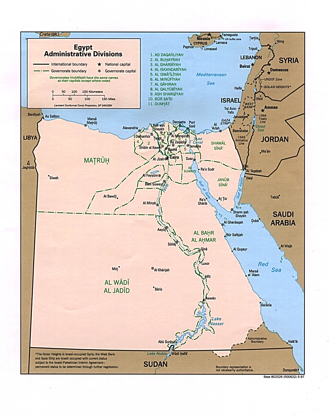
At the top of the hierarchy are 27 governorates (singular: محافظةmuḥāfẓa, plural: محافظاتmuḥāfẓat).[7] Each governorate has a capital, typically its largest city, and is headed by a governor, appointed by the President of Egypt, serving at the president’s discretion.
Governors hold the civilian rank of minister and report directly to the prime minister, who chairs the Council of Governors (maglis al-muhafzin) and convenes regular meetings with them.[8][9] The Ministry of Local Development is responsible for coordinating the governors and managing their governorates' budgets.[10]
City governorates, whose boundaries largely coincide with those of a major urban center, fall directly under the authority of its governor and are only subdivided into districts (singular: حيḥay, plural: أحياءaḥya'),[6] each headed by a district head. In Egypt, there are four such governorates, namely the Alexandria Governorate, Cairo Governorate, Port Said Governorate, and Suez Governorate.
The remaining 23 governorates, which encompass both rural and urban areas, operate under a three-tier system that include intermediate municipal units known as centers (singular: مركزmarkaz, plural: مراكزmarakiz). The lowest level of administration is determined by the rural or urban character of the settlement, classified as either a city or a village.[6]
There are additional subdivisions into smaller units and non-administrative census blocks.[11]
In city governorates, districts are further subdivided into non-administrative units called sheyakha (lit. sheikhdom, شياخة). In urban–rural governorates, cities may be divided into districts, although this is not always the case, and these cities may also be subdivided into sheyakhas. Additionally, some cities in those governorates are divided directly into sheyakhas without an intermediate layer.
Two special categories exist outside the traditional administrative structure, but are intended for eventual transfer to local administration:
Separate from administrative divisions, seven economic regions exist for planning purposes, as defined by the General Organization for Physical Planning (GOPP).[14]
History
Centralization after the 1952 revolution
Before the 1952 Egyptian revolution, state penetration of the rural areas was limited by the power of local notables. Under Nasser, land reform reduced those notables' socioeconomic dominance, and the peasants were incorporated into cooperatives, which transferred mass dependence from landlords to the government. The extension of officials into the countryside permitted the regime to bring development and services to the village. The local branches of the ruling party, the Arab Socialist Union (ASU), fostered a certain peasant political activism and coopted the local notables — in particular, the village headmen — and checked their independence from the regime.[15]
Until 1979, local government enjoyed limited power in Egypt's highly centralized state. Under the central government, there were twenty-six governorates (27 today), which were subdivided into counties (In Arabic: مركزmarkaz "center", plural: مراكزmarākiz), each of which was further subdivided into towns or villages.[15] At each level, there was a governing structure that combined representative councils and government-appointed executive organs headed by governors, district officers, and mayors, respectively. Governors were appointed by the president, and they, in turn, appointed subordinate executive officers. The coercive backbone of the state apparatus ran downward from the Ministry of Interior through the governors' executive organs to the district police station and the village headman.[15]
Decentralization under Sadat
State penetration did not retreat under Sadat, though the earlier effort to mobilize peasants and deliver services disappeared as the local party and cooperative withered. However, administrative controls over the peasants remained intact. The local power of the old families and the headmen revived but more at the expense of peasants than of the state. The district police station balanced the notables, and the system of local government (the mayor and council) integrated them into the regime.[15]
Sadat took several measures to administratively decentralize power to the provinces and towns, with limited fiscal and almost no political decentralization. Governors acquired more authority under Law 43/1979,[1] which reduced the administrative and budgetary controls of the central government over the provinces. The elected councils acquired, at least formally, the right to approve or disapprove the local budget. In an effort to reduce local demands on the central treasury, local government was given wider powers to raise local taxes. Local representative councils became vehicles of pressure for government spending, and the soaring deficits of local government bodies had to be covered by the central government. Local government was encouraged to enter into joint ventures with private investors, and these ventures stimulated an alliance between government officials and the local rich that paralleled the infitah alliance at the national level.[citation needed]
Under Mubarak
Under president Hosni Mubarak's rule (1981–2011), decentralization continued to evolve. Some scholars believed local autonomy was achieved, as local policies often reflected special local conditions. Thus, officials in Upper Egypt often bowed to the powerful Islamic movement there, while those in the port cities struck alliances with importers.[15]
However, others found that local governance proved impotent. Parliamentarians were reduced to the roles of local councillors, lobbying at the parliamentary level for basic local services, while the elected Local Popular Councils (LPC) had a parallel ceremonial role to the appointed Local Executive Councils (LEC), which managed the local departments.[16]
Elections of the LPCs have also been observed to be fraudulent. The ruling National Democratic Party (NDP) won 95 percent of local council seats during the last election in 2008, with 84 percent of the seats won unopposed.[17]
Post-2011 revolution
After Mubarak was deposed by the popular uprising of the January 2011, parliament and local councils were dissolved pending the writing of a new constitution. The short-lived 2012 constitution and the current 2014 version gave wider local power through more decentralization.[9]
However, by the end of 2022, these provisions had yet to be implemented, as the government prolonged the process of drafting a new local administration law, leaving LPC seats vacant for over a decade.[18][17]
List of governorates
Map of Egyptian Governorates
Egypt is divided into 27 governorates (muhāfazāt) and each has a capital and at least one city.[19] Each governorate is administered by a governor, who is appointed by the President of Egypt and serves at the president's discretion. Most governorates have a population density of more than one thousand per km2, while the three largest have a population density of less than two per km2.[20] Administratively, the vast majority of the area of the Sinai Peninsula is divided into two governorates: the South Sinai Governorate and the North Sinai Governorate. Three other governorates span the Suez Canal, crossing into African Egypt: Suez Governorate on the southern end of the Suez Canal, Ismailia Governorate in the center, and Port Said Governorate in the north.
Parts of this article (those related to List of municipal divisions) need to be updated. The reason given is: Needs updating to reflect the new system introduced in 2014, without aqsam. Please help update this article to reflect recent events or newly available information.(March 2025)
Map of Egypt's municipal divisions.
As of 2013, there were 351 subdivisions, of which 177 were qisms, 162 marakiz, 9 new cities, and 3 police-administered areas. There are also unorganized areas in the Alexandria, Aswan, Asyut, Beheira, Beni Suef, Cairo, Dakahlia, Damietta, Faiyum, Giza, Ismailia, Kafr El Sheikh, Luxor, Minya, Port Said, Qalyubia, Qena, Sharqia, Sohag, and Suez governorates.[24]
Parts of this article (those related to Demographics) need to be updated. The reason given is: Needs updating to 2017 census. Please help update this article to reflect recent events or newly available information.(December 2022)
1 Spans the conventional boundary between Asia and another continent.
2 Considered European for cultural, political and historical reasons but is geographically in Western Asia.
This page is based on this Wikipedia article Text is available under the CC BY-SA 4.0 license; additional terms may apply. Images, videos and audio are available under their respective licenses.


