Provinces are the first-level administrative divisions of Indonesia. They were formerly called first-level provincial regions (provinsi daerah tingkat I), before the Reform era. Provinces have a local government, consisting of a governor (Gubernur) and a regional legislative body (Dewan Perwakilan Rakyat Daerah Provinsi, DPRD Provinsi). The governor and members of local representative bodies are elected by popular vote for five-year terms, but governors can only serve for two terms. Provincial governments have the authority to regulate and manage their own government affairs, subject to the limits of the central government. The average land area of all 38 provinces in Indonesia is about 49,800km2 (19,200sqmi), and they had an average population of 7,410,626 people in mid-2024.
Indonesia is divided into 38 provinces, nine of which have special autonomous status. The terms for special status are "Istimewa" and "Khusus", which translate to "special", or "designated". Provinces are further divided into regencies and cities (formerly called second-level region regencies/cities, or kabupaten/kotamadya daerah tingkat II), which are in turn subdivided into districts (kecamatan). Proposals for the creation of additional provinces (by the splitting of existing ones) have been considered by the Indonesian government, but further action has been suspended since 2013 under a moratorium. However, in 2022, nine years later, Central Papua, Highland Papua, South Papua, and Southwest Papua were created and became the youngest provinces in the country. The enactment of the Law on State Capital in 2022 established a future provincial-level city, Nusantara, which would officially become the 39th province after a presidential decree on relocating the state capital is issued, and it would replace Jakarta as the nation's capital city.[1]
Background
Article 18 paragraph 1 of the 1945 Constitution states that "the Unitary State of the Republic of Indonesia is divided into provincial regions and those provincial regions are divided into regencies and city, whereby every one of those provinces, regencies, and municipalities has its regional government, which shall be regulated by laws."
According to the Law on Regional Government (UU 23/2014) the authority of the Provincial Government includes:
Development planning and control;
Planning, utilization, and community peace;
Implementation of public order and public peace;
Provision of public facilities and infrastructure;
Handling the health sector;
Education and allocation of potential human resources;
Handling social problems across regencies/cities;
Services in the field of manpower across regencies/cities;
Facilitating the development of cooperatives, small and medium enterprises, including across districts/cities;
Environmental control;
Defense services, including across regencies/cities;
Population and civil registration services;
Government general administration services;
Investment administration services, including across regencies/cities;
The implementation of other basic services that cannot be carried out by regencies/cities; and
Other mandatory affairs mandated by laws and regulations.
The authority of the provincial government are government affairs which are located across regencies/municipalities, government affairs whose users are across regencies/municipalities, government affairs whose benefits or negative impacts lie across regencies/municipalities, government affairs which use more resources. efficient if carried out by the province.
Each province has a local government, headed by a governor and a legislative body (DPRD). The governor and members of local representative bodies are elected by popular vote for five-year terms, but governors can only serve for two terms. The general election to elect members of the DPRDs is conducted simultaneously with the national general election. Previously, the general elections for Governor and Vice Governor were not held simultaneously. However, since 2015 regional head elections have been held simultaneously. Under the plan, simultaneous partial local elections were held in February 2017, June 2018 and December 2020, culminating in simultaneous elections for all local executive posts in November 2024 and then every five years.
The decentralization of some power and autonomy to provinces is called for by Article 18 of the Constitution of Indonesia, and this article was expanded through amendments in October 1999 in the period following the fall of Suharto.[7]:35–37 Some provinces have been granted additional autonomy beyond this, although Indonesia is not a federated state. The form this special autonomy takes is not standardized, with provinces gaining different formulations of specific autonomy based on particular political imperatives.[7]:38–39
The Special Region of Yogyakarta, which was autonomous under Dutch rule, was (along with Surakarta) given consideration for autonomy as part of Law no. 1 of 1945. Autonomy for Yogyakarta was confirmed directly through Law no. 3 of 1950, the first granting of special autonomy to a province. This status has been maintained until the present, with some tweaks from additional laws.[7]:39–40 Sultan Hamengkubuwono serves as a hereditary governor and Adipati Paku Alam as a hereditary vice-governor.
Rebellion in Aceh due to demands for a stricter implementation of Islamic law has led to several shifts in political status. Specific autonomy was initially granted to the province through Law no. 24 of 1956. Further autonomy was given through the declaration that Aceh was a "special region" on 23 May 1959, later formalized through Law no. 18 of 1965. Following the fall of Suharto, Law no. 44 of 1999 and Law no. 18 of 2001 created a new framework that was adopted by both parties through Law no. 11 of 2006. This law provides privileged status regarding implementation of Islamic law in religious life, customary life and education for Muslim citizens. Aceh also received its own development fund for a period of 20 years.[7]:44–46
The province of Papua was granted special autonomy through Law no. 21 of 2001. This was a response to independence movements that had been present in the province since it became part of Indonesia, and occurred alongside the renaming of the province from Irian Jaya to Papua.[7]:42–43[8] This gave Papua a greater portion of revenue, autonomy outside reserved areas maintained by the central government, and 20 years of a special development fund. Before special autonomy was implemented, West Papua was split from Papua in 2003, although both kept special autonomy.[9] The special autonomy for both provinces was renewed in 2021, including a renewal and increase of the special autonomy fund.[10] Included in this new legislation was the provision to create new provinces, and in July 2022 new national legislation split South Papua, Central Papua, Highland Papua from Papua[11] through Law Number 14 of 2022, Law Number 15 of 2022, and Law Number 16 of 2022 respectively.[8] Law No. 29 of 2022 was enacted in December 2022 splitting Southwest Papua from West Papua.[12] All the split provinces retained their autonomous status.
The provinces are officially grouped into seven geographical units for statistical and national planning purposes, but without administrative function.[14]
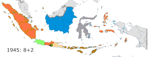
Evolution of Indonesia's provinces from 1945 until North Kalimantan's establishment in 2012
Three-province Sumatra (1948–56) (L) and two-province Sulawesi (1960–64) with present-day regency borders
Upon the independence of Indonesia, eight provinces were established. West Java, Central Java, East Java, and Maluku still exist as of today despite later divisions, while Sumatra, Kalimantan, Sulawesi, and Nusa Tenggara, formerly Lesser Sunda (Sunda Kecil) were fully liquidated by dividing them into new provinces. The province of Central Sumatra existed from 1948 to 1957, while East Timor was annexed as a province from 1976 until its power transfer to UNTAET in 1999 prior to its independence as a country in 2002.
New provinces made from currently-existing provinces
Pre-1999 Maluku (L) and Irian Jaya (now Papua, R) with present-day regency borders
Provinces in Western New Guinea, after the split of Papua Province into four provinces in June 2022 and after the split of West Papua Province into two provinces in December 2022
↑Jakarta is a city with province-level Capital Special Region comprising five Kota Administrasis (administrative cities/municipalities) and one Kabupaten Administrasi (administrative regency). It has no de jure capital, but many governmental buildings are located at Central Jakarta.
↑Figures adjusted to take account of the separation of Tarakan city and four regencies, as confirmed by Badan Pusat Statistik, to form the new province of North Kalimantan, listed separately in this table.
↑West Papua was created from the western portion of Papua province in February 2003, initially under the name of Irian Jaya Barat, and was renamed Papua Barat (West Papua) on 7 February 2007. The split remains controversial. In November 2004, the Constitutional Court of Indonesia ruled that the split violated Papua's autonomy laws. However, since the western province had already been created, it should remain separate from Papua. The ruling also aborted the creation of another proposed province, Central Irian Jaya, because the proposed split had not yet been completed. ISO 3166-2 codes have subsequently been published for all of the newly-created provinces in Indonesian Papua.
This page is based on this Wikipedia article Text is available under the CC BY-SA 4.0 license; additional terms may apply. Images, videos and audio are available under their respective licenses.