
The Mentawai Islands Regency are a chain of about seventy islands and islets approximately 150 kilometres off the western coast of Sumatra in Indonesia. They cover 6,033.76 km2 and had a population of 76,173 at the 2010 Census and 87,623 at the 2020 Census. Siberut at 3,838.25 square kilometres is the largest of the islands. The other major islands are Sipura, North Pagai, and South Pagai. The islands lie off the Sumatran coast, across the Mentawai Strait. The indigenous inhabitants of the islands are known as the Mentawai people. The Mentawai Islands have become a noted destination for surfing, with over 40 boats offering surf charters to international guests.
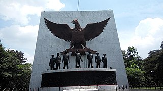
East Jakarta is the largest of the five administrative cities which form the Special Capital Region of Jakarta, Indonesia. It had a population of 2,693,896 at the 2010 Census and 3,037,139 at the 2020 Census, making it also the most populous of the five administrative cities within Jakarta. East Jakarta is not self-governed and does not have a city council, hence it is not classified as a proper municipality.

Indonesia is divided into provinces. Provinces are made up of regencies (kabupaten) and cities (kota). Provinces, regencies and cities have their own local governments and parliamentary bodies.
In Indonesia, village or subdistrict is the fourth-level subdivision below a district, regency/city, and province. There are a number of names and types for villages in Indonesia, with desa being the most frequently used for regencies and kelurahan for cities. According to the 2019 report by the Ministry of Home Affairs, there are 8,488 urban villages and 74,953 rural villages in Indonesia.

Ciracas is a district (kecamatan) of East Jakarta, one of the five administrative cities of Jakarta, Indonesia. Ciracas is the southernmost district in Jakarta. The area of Cibubur Scout's camping ground complex is located partly within the Ciracas District, although the main camping ground area is located in Cipayung District. The boundaries of Ciracas District are: Cipinang River to the west, Cipinang River - Jambore Road to the south, Jagorawi Tollroad to the east, and Kelapa Dua Wetan Road to the north.

Bangli Regency is the one and only landlocked regency (kabupaten) of Bali, Indonesia. It covers an area of 520.81 km2 and had a population of 215,353 at the 2010 Census and 258,721 at the 2020 Census. Its regency seat is the town of Bangli.

Buleleng is a regency (kabupaten) of Bali, Indonesia. It has an area of 1,365.88 km2 and population of 624,125 at the 2010 census and 791,910 at the 2020 census. Its regency seat is at the town of Singaraja.

Gunung Mas Regency is one of the thirteen regencies of Central Kalimantan Province, Indonesia. The regency seat is located at the town of Kuala Kurun in Kurun District. The population of Gunung Mas Regency was 96,900 at the 2010 Census ; and 135,373 at the 2020 Census.

Southeast Maluku Regency is a regency of Maluku, Indonesia. It is coincident with the Kei Islands, except that the city of Tual, although within the Kei Islands geographically and the seat of the Regency's administration, is technically independent of the Regency. The land area of the Regency is 1,031.81 km2, while the sea area administered by the regency was 3,181 km2; it had a population of 96,442 at the 2010 Census; this increased to 121,511 at the 2020 Census. The capital is located in Langgur.

Blitar Regency is a regency in East Java, Indonesia. It covers an area of 1,558.79 km2 and had a population of 1,116,639 at the 2010 Census and 1,223,745 at the 2020 Census; the official estimate as at mid 2021 was 1,242,207. Since 2010, its capital has been located in Kanigoro, after sharing the same capital with Blitar city for more than a century. Blitar city is now a separate administrative entity, enclaved within the regency but completely independent from it.
A kampong is the term for a village in Brunei, Indonesia, Malaysia and Singapore and a "port" in Cambodia. The term applies to traditional villages, especially of the indigenous people, and has also been used to refer to urban slum areas and enclosed developments and neighbourhoods within towns and cities in Brunei, Indonesia, Malaysia, Singapore, Cambodia, Sri Lanka and Christmas Island. The traditional kampong village designs and architecture have been targeted for reform by urbanists and modernists and have also been adapted by contemporary architects for various projects.
Pedukuhan Ngande - Ande is located in Kelurahan Purwodadi, Kecamatan Tepus, Gunungkidul, Yogyakarta Special Region, Indonesia. The name of Ngande - Ande comes from the tree, called Ande-ande Tree.

A rukun tetangga is an administrative division of a village in Indonesia, under a rukun warga. The RT is the lowest administrative division of Indonesia.
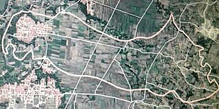
Dukuhjati Wetan is one of the villages located in the district of Kedungbateng, Tegal, Central Java, Indonesia.
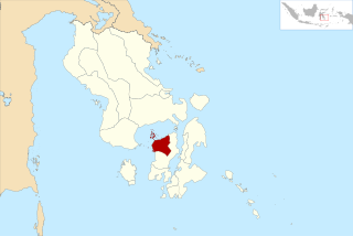
West Muna Regency is a new regency of Southeast Sulawesi, Indonesia, established under Act No.14 of 2014, dated 23 July 2014 by separation from the Muna Regency. It covers an area of 906.28 km2, and the districts comprising it had a population of 71,632 at the 2010 Census; the 2020 Census resulted in a population of 84,590, and the official estimate as at mid 2021 was 84,777, comprising 41,888 males and 42,889 females.The administrative centre lies at Laworo.

Central Buton Regency is a new regency of Southeast Sulawesi established by separation from Buton Regency under Act No.15 of 2014, dated 23 July 2014. It covers an area of 837.08 km2 comprising the southern parts of Muna Island and Kabaena Island, together with several small offshore islands adjacent to the two main islands, with no territory located on Buton Island. It had a population of 86,112 at the 2010 Census and 114,773 at the 2020 Census; the official estimate as at mid 2021 was 116,599. The administrative centre lies at Labungkari.
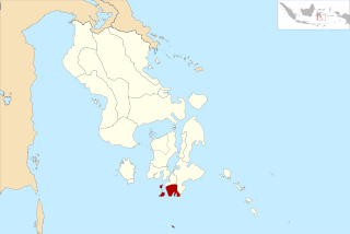
South Buton Regency is a regency located in Southeast Sulawesi. This regency was formed from the southern part of Buton Regency, from which it was separated by Act No.16 of 2014, dated 23 July 2014. It covers an area of 546.58 km2, and the population of the districts now comprising the new regency was 74,974 at the 2010 Census and 95,261 at the 2020 Census; the official estimate as at mid 2021 was 95,472. The regency capital is located in Batauga.
In Indonesian law, the term "city" is generally defined as the second-level administrative subdivision of the Republic of Indonesia, an equivalent to regency. The difference between a city and a regency is that a city has non-agricultural economic activities and a dense urban population, while a regency comprises predominantly rural areas and is larger in area than a city. However, Indonesia historically had several classifications of cities.
Muara Gembong is a district of Bekasi Regency, West Java, Indonesia.
