A municipality is usually a single administrative division having corporate status and powers of self-government or jurisdiction as granted by national and regional laws to which it is subordinate.
Administrative divisions are geographical areas into which a particular independent sovereign state is divided. Such a unit usually has an administrative authority with the power to take administrative or policy decisions for its area.
A county is a geographic region of a country used for administrative or other purposes in some nations. The term is derived from the Old French comté denoting a jurisdiction under the sovereignty of a count (earl) or a viscount. Literal equivalents in other languages, derived from the equivalent of "count", are now seldom used officially, including comté, contea, contado, comtat, condado, Grafschaft, graafschap, and zhupa in Slavic languages; terms equivalent to 'commune' or 'community' are now often instead used.
A prefecture is an administrative jurisdiction traditionally governed by an appointed prefect. This can be a regional or local government subdivision in various countries, or a subdivision in certain international church structures, as well as in antiquity a Roman district.
A district is a type of administrative division that in some countries is managed by the local government. Across the world, areas known as "districts" vary greatly in size, spanning regions or counties, several municipalities, subdivisions of municipalities, school district, or political district.
Between 1634 and 2009, Finland was administered as several provinces. Finland had always been a unitary state: the provincial authorities were part of the central government's executive branch and apart from Åland, the provinces had little autonomy. There were never any elected provincial parliaments in continental Finland. The system was initially created in 1634. Its makeup was changed drastically on 1 September 1997, when the number of the provinces was reduced from twelve to six. This effectively made them purely administrative units, as linguistic and cultural boundaries no longer followed the borders of the provinces. The provinces were eventually abolished at the end of 2009. Consequently, different ministries may subdivide their areal organization differently. Besides the former provinces, the municipalities of Finland form the fundamental subdivisions of the country. In current use are the regions of Finland, a smaller subdivision where some pre-1997 läänis are split into multiple regions. Åland retains its special autonomous status and its own regional parliament.
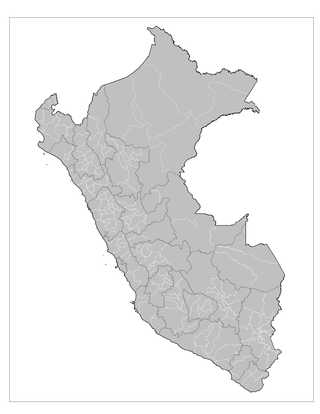
The administrative divisions of Peru have changed from time to time since the nation gained independence from Spain in the early 19th century. The old territorial subdivisions have split or merged due to several reasons, the most common ones being the need for decentralization and population increase, especially in Lima.

La Libertad is a department and region in northwestern Peru. Formerly it was known as the Department of La Libertad. It is bordered by the Lambayeque, Cajamarca and Amazonas regions on the north, the San Martín Region on the east, the Ancash and Huánuco regions on the south and the Pacific Ocean on the west. Its capital is Trujillo, which is the nation's third biggest city. The region's main port is Salaverry, one of Peru's largest ports. The name of the region is Spanish for "freedom" or "liberty"; it was named in honor of the Intendancy of Trujillo's proclaiming independence from Spain in 1820 and fighting for that. It is the ninth smallest department in Peru, but it is also its second-most populous department after Piura and its second-most densely populated department after Lambayeque.

Loreto is Peru's northernmost department and region. Covering almost one-third of Peru's territory, Loreto is by far the nation's largest department, slightly larger than Japan; it is also one of the most sparsely populated regions due to its remote location in the Amazon Rainforest. Its capital is Iquitos.

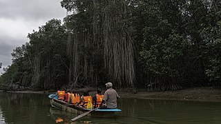
Tumbes is a coastal department and region in northwestern Peru bordering Ecuador. Due to the region's location near the Equator it has a warm climate, with beaches that are considered among the finest in Peru. Despite its small area, the region contains a wide variety of ecosystems. It is the smallest department in Peru and its third least populous department after Moquegua and Madre de Dios, but it is also its third most densely populated department, after La Libertad and Lambayeque.

The provinces of Peru are the second-level administrative subdivisions of the country. They are divided into districts. There are 196 provinces in Peru, grouped into 25 regions, except for Lima Province which does not belong to any region. This makes an average of seven provinces per region. The region with the fewest provinces is Callao (one) and the region with the most is Ancash (twenty).

The districts of Peru are the third-level country subdivisions of Peru. They are subdivisions of the provinces, which in turn are subdivisions of the larger regions or departments. There are 1,838 districts in total.

A commune is the smallest administrative subdivision in Chile. It may contain cities, towns, villages, hamlets as well as rural areas. In highly populated areas, such as Santiago, Valparaíso and Concepción, a conurbation may be broken into several communes. In sparsely populated areas, conversely, a commune may cover a substantial rural area together with several settled areas which could range from hamlets to towns or cities.

According to the Organic Law of Regional Governments, the regions are, with the departments, the first-level administrative subdivisions of Peru. Since its 1821 independence, Peru had been divided into departments but faced the problem of increasing centralization of political and economic power in its capital, Lima.
ISO 3166-2:PE is the entry for Peru in ISO 3166-2, part of the ISO 3166 standard published by the International Organization for Standardization (ISO), which defines codes for the names of the principal subdivisions of all countries coded in ISO 3166-1.
Ubigeo is the coding system for geographical locations in Peru used by the National Statistics and Computing Institute to code the first-level administrative subdivision: regions, the second-level administrative subdivision: provinces and the third-level administrative subdivision: districts. There are 1874 different ubigeos in Peru.

The following outline is provided as an overview of and topical guide to Peru:


